Tag Archives: Urban Design

Biking on Campus

Transportation around UMKC campus feels limited for UMKC being a commuter campus. Most students park their cars in lots or parking garages and walk to their classes from their parking spots. It is not feasible to drive to every class on campus so providing other realms of transportation like electric bikes.

I chose to take one of the electric bikes for a ride on campus to see the logistics of riding on campus and how effective it can be instead of walking to classes. UMKC’s campus consists of different contours that can be more difficult to walk and bikes could really come in handy. Below is a map of the route I took.

I started by downloading the BikeKC app on my phone and going to the bike charging station near Whole Foods. I parked in the School of Education parking lot so I knew I wanted to bike from Whole Foods to there.

The app was easy to work and I was riding shortly after getting to the charging station. The bikes can be intimidating at first because of the speed, but luckily I chose a route with smooth sidewalks.

The first mental note I made was that the sidewalks were actually in good condition. They felt a little narrow to ride an E-bike on when there were other people walking on the sidewalks, but they were still in good shape. Protected bike lanes on campus eventually could be a good addition. The intersection at 52nd and Cherry felt a little steep and dangerous because its a large intersection, but again, I felt safe because I had the sidewalk to ride on. I do wish there was a crosswalk at this intersection.

Riding down Oak St. to 52nd street felt boring aesthetically and a little unsafe. Oak street keeps pretty busy in terms of the traffic flow and the sidewalk is again narrow.

I ended at the Education Building parking lot at the end of my ride. There was nowhere to return my bike at a charging station in the near area, so this was not convenient.

Overall, I think the addition of BikeKC to campus could be a great one with more charging stations and bikes available. I also believe adding bike lanes on main streets of campus and cross walks at all intersections will keep those safe who are riding bikes.

Why Oak Street?

When thinking about UMKC campus and its interface connection to the city as it stands, one word I have to describe it is disconnected. Campus is integrated into the heart of KCMO. Minutes from the Plaza, Westport, and so much more, UMKC’s campus has the potential to be involved in the city and provide amenities to those on campus but also in surrounding neighborhoods. 

Integrating campus into the community is a great way to get a better connection between the two. I chose Oak st. because the possibilities are endless. 

Encouraging Oak St. Corridor to become a pedestrian friendly street opens up opportunities for community/public engagement and creates a good interface connection. Being minutes from KC assets like the Nelson Atkins Museum is a great motivator for a pedestrian friendly street. Those traveling down Oak on foot get a sense of campus community when approaching the redeveloped stairs of Oak St./The entrance of campus. 

Promoting Oak as a walkable, pedestrian activated street creates a connection to other parts of the city as well as the Trolley Track Trail additions. 

Elements of the Public Realm: Parking

Elements of the public realm are public elements existing within communities. These elements can be things like plazas, courtyards, public streets or parking. Elements of the public realm should embody ideas of circulation and easy access.

Parking is a very important element to the public, especially on university campuses. For this blog, we will be taking a look at University of Missouri – Kansas City’s current parking situation.

UMKC is a commuter campus, meaning more students live off campus than on campus. Many of these students drive their own personal vehicles which are then needed to be parked on UMKC’s campus or surrounding areas while students are in class.
Figure 1.0 shows UMKC’s current parking map displayed on their website.

Figure 1.0
There is a mix between metered parking, student parking (those who have parking permits), and faculty/staff parking. There is also some off campus street parking, but not much in comparison to the amount of assigned parking for UMKC’s campus.
Figure 2.0

Figure 2.0 above gives a map of campus with all of the parking shown in blue. Some are parking lots, like the Katz Hall lot, and some are parking garages or the public street parking on campus.

When doing research about how far people will walk from their parking spot to their destination, I wanted to put theories to the test on campus.

I believed that there was enough parking for UMKC Campus students, but that the parking just is not in great areas. I know that when I pay a lot of money for a parking pass, I would really like to be within a five to seven minute walk of my classes. Shown in Figure 3.0 is a map showing the parking locations radius’ in regards to campus and its amenities. The distance is about .2 miles or about a five minute walk.

Figure 3.0
As you can see, campus parking is actually all within a 5-7 minute walk of campus and its amenities. I was surprised to find this information out. I also wanted to show some sketches of a campus parking garage on Cherry St. and the Katz Hall small lot that most of us park in currently when attending classes on campus in the UPD Program.

Overall, I think it is important to note that campus has a lot of parking and it is all relatively close to classes and other places students need to get to on campus. What a more prevalent issue may be is how to make campus feel more walkable so those 5-7 minutes feel like 2-3 and the walk is smoother to class than it currently is. This could be solved through topographic interventions and other related resources.


Campus Connectivity

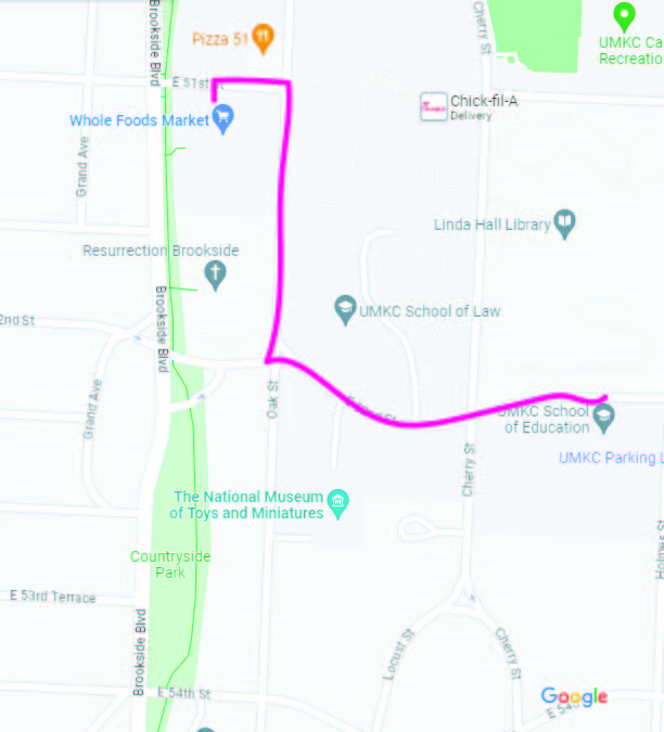
My detailed area study is located near the central part of campus while encompassing some of the South-Western part of campus. Figure 1. Below shows my assigned blocks for the detailed area study. 
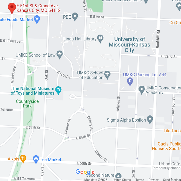
Figure 1. www.googlemaps.com 

I had 51st to 54th street and Grand Ave. to Holmes St. for my assigned area.

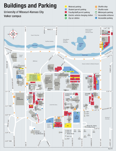
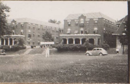
Many UMKC resources and facilities are located in the areas of 51st to 54th streets and Grand to Holmes from the East to West as well as non-university development. My area includes the UMKC School of Education, UMKC School of Law, the Linda Hall Library, and the Henry W. Bloch School of Management. These are all active facilities used by UMKC students in the present day and are considered assets of the campus. Another notable structure in my assigned area is the Epperson House located at 5200 Cherry Street. A photo of the Epperson House is shown below in Figure 2. The Epperson House was given to UMKC as a gift in 1940. While it still stands today, it is not currently being used. Epperson House is a great historic asset. I would love to see it repurposed on campus and be used for classes or maybe a study center. 

Figure 2. https://www.bizjournals.com/#

Another important asset to not only campus but also Kansas City, is the Henry W. Bloch school 
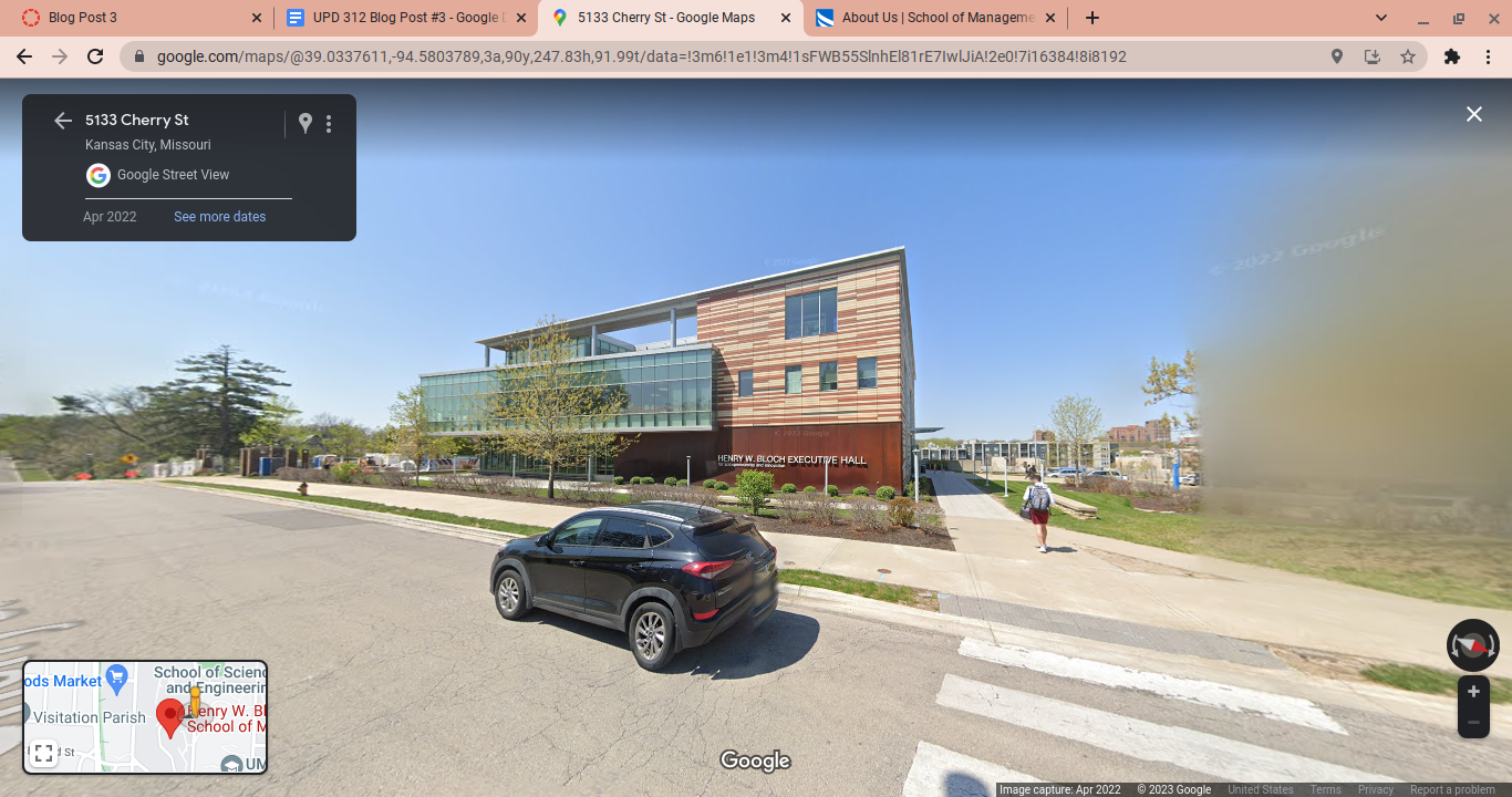
at 5128 Cherry St. Shown below in figure 3 is the Bloch Management School. Mr. Bloch, whom donated the money to build the facility and is also the namesake, is the co-founder of H&R Block Tax Services. (https://bloch.umkc.edu/about-us/) His ability to produce the Bloch Management School gives an opportunity for students to give back to the environment they attended school in due to the degree they were able to obtain at the Bloch school. It benefits the economy this way. 

Another important asset to UMKC campus and students specifically is the Whole Foods located on the bottom floor of Brookside 51 which are apartments located directly east of Brookside Blvd. which is just a short distance from the Student Union. These apartments are in a great location for students to live off campus but they are pretty expensive. They range from $1,455 a month to almost $3,500 and being a student myself, I know this is not affordable. The Whole Foods is valuable because it serves the student housing population as their grocery story without having to travel far or even drive. It is within walking distance to the dorms. 

Along my assigned area is also the Trolley Track Trail to the West of my assigned blocks. This trail sees moderate activity.

During the first weeks of class, I learned that many students commute to UMKC. Few students actually live on campus in dorms. The amount of parking lots at UMKC lock-in this theory that UMKC is a commuter campus/school. In order to help UMKC become a full-encompassed school with many more students living on campus, the student housing options must be improved first. I believe more affordable student housing, even if it isn’t dormitories, would draw students to live closer to campus, therefore being able to walk to campus instead of commuting. UMKC’s sidewalks are in good shape which is important for walkability on campus. They could improve on signage. I have a hard time identifying buildings on campus because some of them you really only catch glimpses of driving by or you see the backside and the name of the building is only on the front. 

On many of my assigned streets there are no bicycle lanes. As a city moving towards environmental sustainability, more students may be inclined to ride bikes on campus or motorized d scooters. Bike lanes would be beneficial. Below in figure 4 is a two-way bike lane at UC Berkley. This allows for some car traffic, foot traffic and bicycle traffic in an organized fashion. I picture this Cherry street, in front of the Student Union shown below in figure 5.
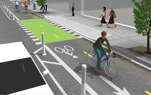
 Figure 4. 

Figure 5. Implementation of a bike lane on Cherry St. 

Another aspect that makes me feel like some parts of UMKC are “closed off” from the campus are fences and setbacks. Some buildings like the Education building feel setback far from the street and not super inviting, in my opinion. The entrance to this building also feels cold and uninviting. Linda Hall library contains a fence around the building. To me, this signifies the building and land are fenced off and it is lengthy to search for the ONE entrance to the library. I would prefer an entrance like the Miller Nichols Learning Center where the doors are visible from the road. 

All in all, UMKC is definitely a commuter campus. Adding more affordable student housing and dorms along with intricate shared roadways for cars, bikes, and pedestrians would make students feel more willing to embrace the walkability that a campus should have and feel.

Bi-State Sustainable Reinvestment Corridor

Map of corridor
Census Tracts in the Corridor.

Design and Development in the Bi-State Reinvestment Corridor of Kansas City

This semester UP+D Studio 312 will be examining the Bi-State Sustainable Reinvestment Corridor of Kansas City, This corridor will combine net-zero electric transit with strategic investments to address environmental justice and economic development.

Improving the corridor requires thinking about some major urban issues of the present time. First, How did the big issues of urban change such as redlining, urban renewal, deindustrialization, and highway construction impact the corridor? Then, what are the existing plans for the corridor? How will we address the issue of housing affordability? Housing costs have been rising 3X faster then income in greater Kansas City. What assets do neighborhoods bring to the bi-state corridor plan? What are the present environmental conditions on the corridor and are their environmental justice hotspots? UMKC might best thought of as a “school zone” and a reduced speed on at least Rockhill and Oak Street might greatly improve safety. How will bicycle facilities and trails cross the corridor and connect to improved transit?

We will conduct this study in four parts – We will start with an Existing Conditions Analysis examining economic, transport, social and demographic trends impacting the neighborhoods and areas around corridor; then conduct a detailed analysis of site conditions and on-the-ground impressions of the corridor, identify strategic nodes for student intervention proposals, followed by the development of final design proposal for catalytic “transit-oriented development” that will advance Independence, and both Kansas City, Missouri and Kansas City, Kansas.

Main and Linwood 2022

What’s next for a key crossing in Midtown?

Main Street between Downtown Kansas City and the Country Club Plaza has a mixed character. At 39th Street and Westport Road it is the entry point of Westport. At other times, Main Street has little or no character – other than that of an arterial trafficway. Concentrations of auto-based uses and parking lots adjacent to the street create a hostile environment to pedestrians. With the advent of the streetcar connection coming in 2024/2025, these voids may soon be targeted for redevelopment. This semester we are asking about the future for Main and Linwood.

What should this corner look like in the future?

How do we build anew without harming existing businesses and residents?

Can we address important issues of inclusion and social justice at this site while increasing neighborhood security and wealth?

Elements of the Public Realm

For this public realm study, I analyzed what makes a public place to sit desirable. I broke my analysis down into three main focuses: hostile architecture, age friendliness, and place making. When looking at these topics, and the places to sit I found around the city, I found that Kansas City is lacking in effective, desirable places to sit.

For my first board, I included perspective views of the benches and seating options. For This board, I just wanted to have clear images of the seating so the viewer and interpret how they feel about each of the seats. The board is organized so that the best practices are at the top of the board and the worst examples are on the bottom. The best examples I found were from the Troost Lake Shelter, and the Oppenstein Brothers Memorial Park in downtown Kansas City. Though these two examples appear very different, they share the organic, natural flow and variety in seating options that I found to make the seating most successful.

I wanted to make my plan diagrams as simple as possible so that the viewer can determine what are the important factors when it comes to public seating. I saw shade and trees as being the most important elements to successful seating. For most people, finding a shady spot to sit is most desirable on a warm day. The trees can also provide a sense of privacy and protection. They help create space around the seating that makes it inviting and pleasant. I felt as though lacking in trees made the seating options less desirable . For the most successful examples, #1 and #2, there is plenty of trees for shade and the trees create a sense of space.

Finally, when creating my theory board I thought of the best ways to diagram why the different seating is successful. The first example of best practice, the Troost Lake Shelter, is in a very interesting location. There aren’t many lakes in Kansas City, this makes the lake shelter more appealing for people to come and make their own. In the circulation diagram you can see that the flow of pedestrians through the space is very organic and there is a lot of variety in how you can approach sitting there. I also included a drawing of the type of seating I liked most from the example, the picnic table. I like this option because there is almost endless possibility in how you can use this seating. It is great for eating, sitting and even laying down. The second example a urban park is very different in its setting, but is still successful for all the same reasons. It is an organic space, with a wide variety of seating types. From movable chairs and tables to walls and park benches there is a great variety. Both of these examples do not use hostile architecture. The benches are welcoming and comfortable and the movable chairs and tables couldn’t be more inviting. The spaces were both accessible for elderly and handicapped individuals and they both really are distinctive in their sense of place.

Historical Analysis

1890 Study Area
1920 Study Area
1950 Study Area
1990 Study Area
2020 Study Area

I started with the base present day GIS file, I made sure that the buildings on the GIS file matched up with Google Earth. Next, I obtained the historical images of the site. For each image I overlaid the information on top of the original files and added and deleted files as needed. I noticed that there was a building boom from 1890 to 1920. 1920-1950 seems to be the peak of development for this study area, in the present day map there are less structures than there were 70 years ago. This is the most noticeable when looking at either side of Flora Ave. At its peak, there was a house on every parcel on both sides of the street, but today there are less houses. I also thought it was interesting that the parcels south of 31st Street between Flora and Wane Ave never was developed. To this day it is still vacant. I also thought the corner of 30th and the Paseo ave. was interesting in how the shape and size of the building changed over time. Throughout history this building has been one of the most notable features in the two block area.

I would characterize this area as mostly residential, both single and multifamily residential fills most of the area, with a few larger non residential buildings below 31st St. There are a few buildings that still stand from the 1940s Tax assessment photographs. I included two below, one of a single family home on Flora ave, and a large apartment building on Paseo ave. Most of the houses in this area were built in the 1980s. The largest landmark would be Troost park, to the west of my study area. The large apartment buildings and the buildings south of 31st st. Overall, I found the history of this area interesting, it has always been largely residential, with higher density structures on the east side of Paseo ave. and along the 31st st corridor.

TROOST HOUSING INFILL

Sarah Davis

This is a small single family development originally located at 3917 Valentine Rd. I plan on moving it to Flora Ave, in the study area around Troost Park. I chose this example because it has a nice facade and landscaping. I thought it would fit in well with the surrounding single family dwellings on this street. It is located a couple short blocks from the park, being a selling point for young families. The house currently sits on a 7,019 sq ft parcel, and is developed at 6 dwelling units per acre. This classifies the development as small, it has a floor area ratio .79. Overall, I saw the house as a nice fit for the surrounding context.

Small Development 3917 Valentine Rd

This is a medium multi-family development originally located at 2418 Linwood Blvd. It is currently being used as office space, but it was initially built for apartment homes. I plan to move it to 3014-28 Tracy Ave. For this move, I would have to combine multiple smaller parcels to have enough space for this development. I thought it would blend in well with the surroundings, with the current lot adjacent to an apartment building as well. This development would bring in many new families to the area of different sizes, it would be perfect for single people, adults with no kids or families with kids. The building is developed at 20 dwelling units per acre, making it it a medium development. It has a floor area ratio of 1.39. Being directly across the street from the park would also create around-the-clock eyes on the street to make the park and the area overall a safer place.

Medium Development on Tracy

This is a large multi-family development originally located at 4700 Roanoke Parkway. It has recently been remodeled, making it a perfect pick for a new development for my selected site. I plan to move it to the corner of 30th St. and Tracy Ave, across the street from Troost Park. There is an existing apartment development on the adjacent lot, so the new development would not look out of place on this corner. I believe that developing this intersection would bring attention to the park across the street, and make it a safe place for the residents who live there to walk in the park. This development would also bring a wide array of new residents to the area. it is located near many services such as churches, social services and educational facilities. This apartment is developed at 71 dwelling units per acre making it a very high density development. The added density will certainly add more excitement to the area. The floor area ratio is 3.13. Overall, this development would be perfect to add to this corner adjacent to The Park.

Street Furniture/Amenities

Object

Site

User

The Main Street Corridor from 30th to 51st contains several prominent examples of various street furniture and amenities. To create a taxonomy of street furniture types, I sub-categorized the elements into “seating,” “bicycle,” and “various” multi-use types. Further, I organized each ensuing board according to relationships between each element as an “object,” “site,” and “user.”

My chosen seating examples include bench seating with aggressive skateboarding and loitering deterrence (Westport Rd. and Main), a well-designed “outdoor room” (43rd and Walnut), and the gathering space/memorial at  Murray Davis Park (40th and Main).

The bicycle subheading includes the KC BCycle bike share kiosk (31st and Main), the mobius-strip bicycle racks at Capital Federal Bank (43rd and Main), and the meta-sculptural bicycle rack at 43rd and Walnut.

The “various” multi-use subheading includes the trash, recycling, and periodical containers at 39th and Main; the sculpted stone planter at 33rd and Main; and the Main Street MAX transit stop at Armour.

The underlying relationships between each element of street furniture/amenity involve “proxemic” spatial relationships.  The term proxemics, coined by anthropologist Edward T. Hall in The Hidden Dimension, describes the spectrum of distance that defines the functional space of each element.  I define each element on the proxemic spectrum between “intimate,” “”personal,” “social,” and “public.”  From this analytical starting point, the elements are further defined by their attention to accessibility, human interaction, and aesthetic continuity.  Displayed diagrammatically on the “user” board, each element comprises these themes with varying levels of success.  Overall, the elements which emphasize accessibility for differently-abled individuals, “sociopetal” (inward-facing, interactive relationships), and aesthetic continuity contribute most positively to the public realm.