1890 Study Area1920 Study Area1950 Study Area1990 Study Area2020 Study Area
I started with the base present day GIS file, I made sure that the buildings on the GIS file matched up with Google Earth. Next, I obtained the historical images of the site. For each image I overlaid the information on top of the original files and added and deleted files as needed. I noticed that there was a building boom from 1890 to 1920. 1920-1950 seems to be the peak of development for this study area, in the present day map there are less structures than there were 70 years ago. This is the most noticeable when looking at either side of Flora Ave. At its peak, there was a house on every parcel on both sides of the street, but today there are less houses. I also thought it was interesting that the parcels south of 31st Street between Flora and Wane Ave never was developed. To this day it is still vacant. I also thought the corner of 30th and the Paseo ave. was interesting in how the shape and size of the building changed over time. Throughout history this building has been one of the most notable features in the two block area.
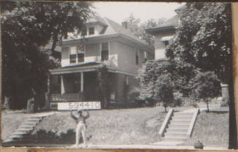
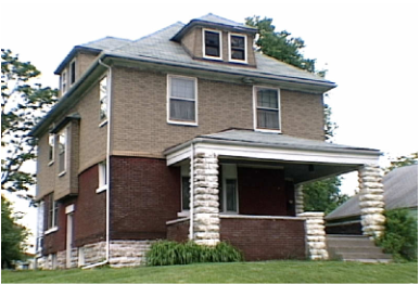
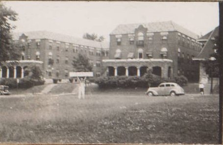
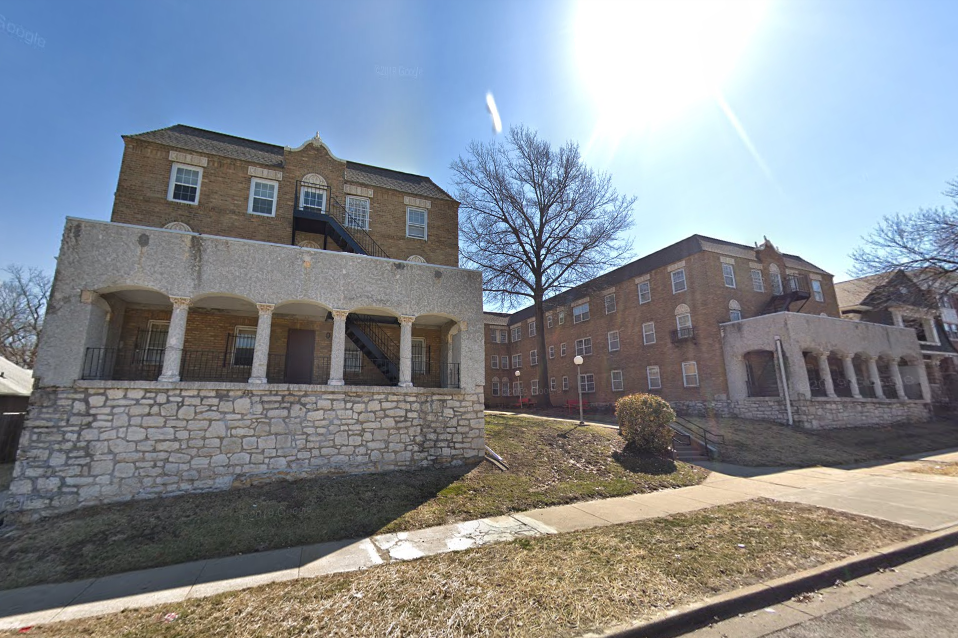
I would characterize this area as mostly residential, both single and multifamily residential fills most of the area, with a few larger non residential buildings below 31st St. There are a few buildings that still stand from the 1940s Tax assessment photographs. I included two below, one of a single family home on Flora ave, and a large apartment building on Paseo ave. Most of the houses in this area were built in the 1980s. The largest landmark would be Troost park, to the west of my study area. The large apartment buildings and the buildings south of 31st st. Overall, I found the history of this area interesting, it has always been largely residential, with higher density structures on the east side of Paseo ave. and along the 31st st corridor.
The area around The Landing Mall began as a suburban escape from the urban core. The southern expansion of Kansas City can be noted by curvy streets and larger parking lots. The surrounding neighborhoods were built around the park and boulevards system in Kansas City, making it a desirable place to live when it began. As suspected, the area surrounding the Landing was not very populated in the 1920s but in the 19603, around when the Landing was built, the area became pretty dense. Since then it has seen some demolition of buildings and the ground is less packed.
1963 Figure Ground Map Surrounding The Landing (1″=200′). Made by Adair Bright2018 Figure Ground Map Surrounding The Landing (1″=200′). Made by Adair Bright
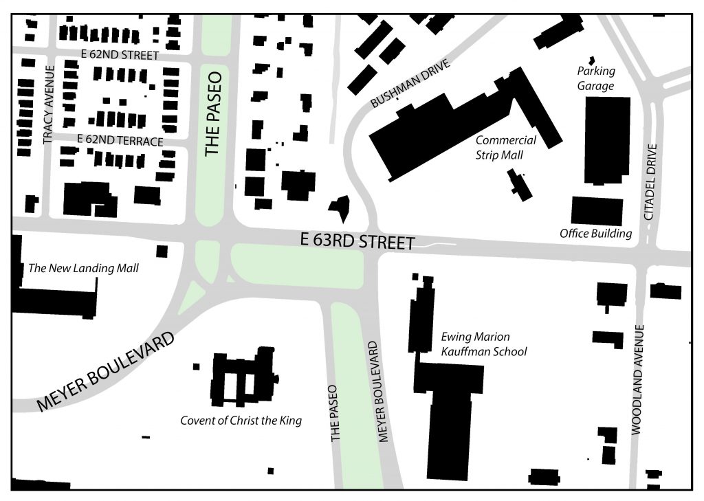
Describing the seemingly complex intersection of 63rd Street, Meyer Boulevard and The Paseo, famed Architect and Urban Designer, Ted Seligson, refers to it as “the knuckle” of Kansas City’s boulevard system. Viewing the intersection from an aerial view, Seligson’s analogy becomes clear. The way Meyer Boulevard merges into The Paseo, then briefly runs parallel with 63rd Street, before finally turning back down into itself, looks like a person’s finger joints. The knuckle, which lies just East of The Landing (which was discussed in my last blog), is a node that various different land uses gather around. Not only is this the case for present day (currently a mix of residential, commercial and institutional uses surround the knuckle) but it has been the case for the past 100 or so years. This post will look at how the area immediately surround the knuckle has developed over time.
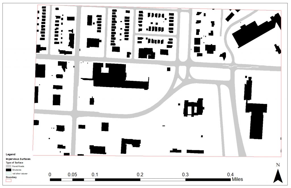
1925 Figure Ground Map – 63rd Street between Tracy and Woodland Avenues. Source: Jared Islas, 2019.
The earliest developments in the area were mostly single-family residences. These homes mostly originated along Tracy and Woodland Avenues, with some additional homes appearing on either side of The Paseo. Many of the homes on Tracy and The Paseo will remain intact through to present day, but the same can not be said for those on Woodland.
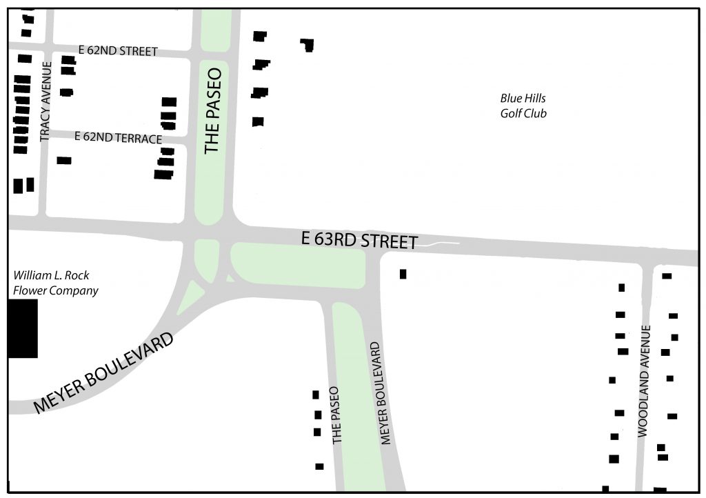
According to the 1925 Atlas of Kansas City, the present-day Landing site was formerly home to two large greenhouses known as “William L. Rock Flower Company.” These greenhouses would also not last long, as they would be sold to JC Nichols in the mid to late 1940’s who would go on to develop The Landing Mall (Kansas City Star, 1947).
Also, just Northeast of the knuckle, sat the Blue Hills Golf Club. This would remain an important part of the neighborhood up the site was redeveloped for a suburban-esque retail shopping center and neighborhood.
1963 Figure Ground Map – 63rd Street between Tracy and Woodland Avenues. Source: Jared Islas, 2019.
By 1963, more single-family residences had filled up the area Northwest of the knuckle and almost all of the houses that had been fronting Woodland Avenue had disappeared. Also, Convent of Christ the King, and some other institutional/office buildings sprung up South of 63rd Street. And The Landing mall was constructed on the former site of the two large greenhouses.
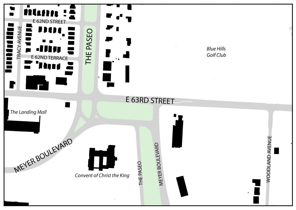
1991 Figure Ground Map – 63rd Street between Tracy and Woodland Avenues. Source: Jared Islas, 2019.
By the early 1990’s, the Blue Hills Golf Club was gone and replaced by the suburban-esque strip mall, a six-story office building and a three-story parking garage. Commercial pad sites began developing around the knuckle and other intersections along 63rd Street.
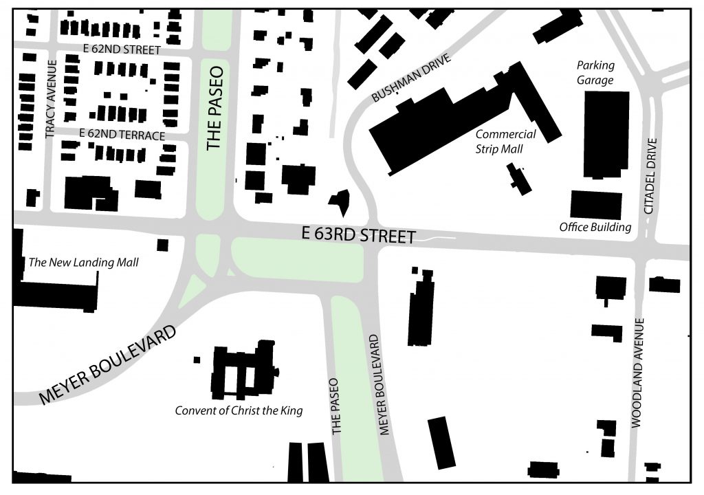
2019 Figure Ground Map – 63rd Street between Tracy and Woodland Avenues. Source: Jared Islas, 2019.
As of today, the area around the knuckle has not changed much since the early 90’s. The only major difference is the large additions to building at the Southeast corner of 63rd and Meyer. These buildings ultimately became the campus for the Ewing Marion Kauffman School, which is a public charter school.
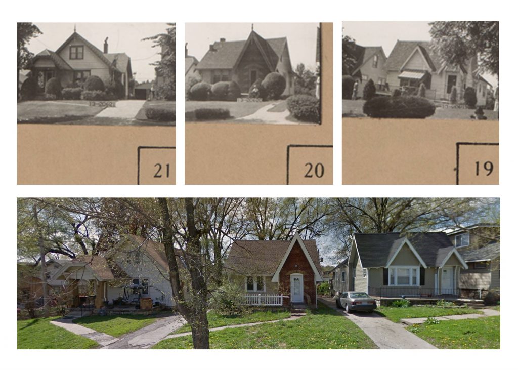
While the structures and their uses surrounding the knuckle have changed in the last 100 years, there are some things that have remained the same. The first being some of the older, now historic, single-family homes on 62nd Terrace. The picture below shows these homes first in 1940, as part of the 1940 Tax Assessment photos, and then again in 2015 through Google Maps Street View.
Comparison of single family homes on 62nd Terrace Source: 1940 Tax Assessor photos and 2015 Google Street View
These structures have remained relatively untouched during the almost 80 year gap that these photos were taken. The only things that have changed are expected renovations in older homes like these – materiality and landscaping.
The next set of photos, comes to the same conclusion. This commercial building, located halfway in between Tracy Avenue and The Paseo on the North side of 63rd Street has also remained relatively unchanged.
Comparison of a commercial building on 63rd Street. Source: 1940 Tax Assessor photos and 2018 Google Street View.
These historic photos show that while there have been some structures that have been around for the better part of the last 80 years, nothing compares to the longevity of the knuckle.