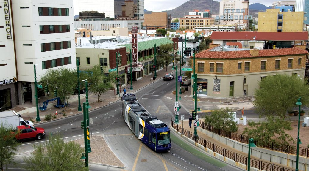
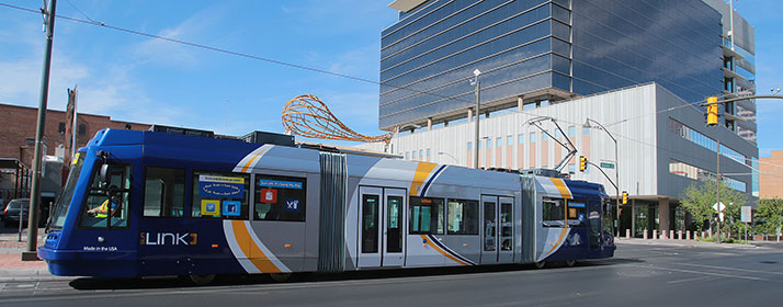
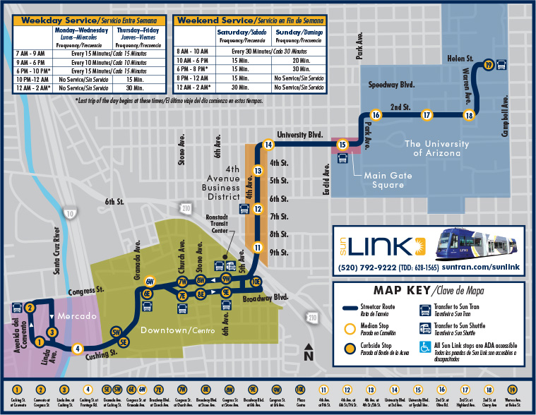
The Sun Link Streetcar system opened in July 25th 2014. It has 23 Stations (17 per direction) with daily ridership around 4,000 (Arizona Daily Star). The length of the line is 3.9 miles, servicing the University of Arizona, Downtown and Mercado. The estimate from the city was 3,600 weekday riders, it exceeded expectations.
One-way full fare is $1.50, a day pass is $4. There is a SunGO card that works for the bus and streetcar and allows a transfer between the two vehicles.
In order to build the Sun Link System, Tucson secured a $63 million federal grant for its modern streetcar. This included the price of tearing up the existing roadway and the laying down of tracks for the streetcar. Currently, fare boxes are on course to bring in $1.2 million per year. With annual operations costs at about $4.2 million, that’s in line with cost recovery ratios for most transit systems.
Zoning Around Downtown Streetcar (MapTucson GIS)
Much of the initial ridership was due to novelty of a tram/streetcar in the downtown area. (Patrick McNamara) According to the Monthly Operations Report, in January 2017 average weekday ridership was at 2,857, which was is an increase from the January 2106 average of 2,757. Both of which are below the projections, however in September and March ridership was at am average of 3,800 on the weekdays. This could be partially due to the large amount of University Students who utilize the streetcar. The ridership for the summer months of 2016 was also comparatively low.
The proposed route of the extended Kansas City Streetcar, terminates at the UMKC Campus. Similarly to Tucson, the KC Streetcar could see an increase of riders during the school semester. However it is important to note that the University of Missouri – Kansas City has a total enrollment of 16,000 and the University of Arizona has a total enrollment of 43,000.
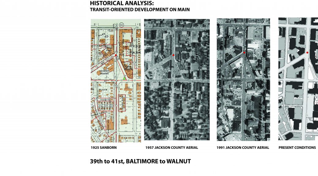
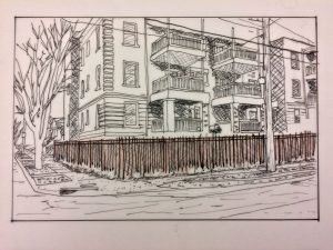
Historical analysis of sections of the Main Street corridor (39th to 41st, from Walnut to Baltimore)
Four maps, a 1925 Sanborn, 1957 and 1991 Jackson County aerials, and a modern GIS layer of present conditions, give insight into the changing dimensions of the corridor throughout time. A common scale of each map allows one to readily see the spatial changes of the built environment.
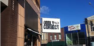
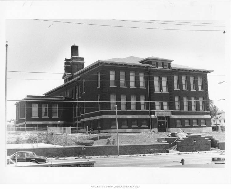
The intersection of Westport Road and Main provides an interesting analytical starting point. At this node, the built environment stayed largely intact between 1925 and 1951. The structures immediately on the corner of Westport Road and Main, now housing the Oddly Correct coffee shop, are intact from 1925.
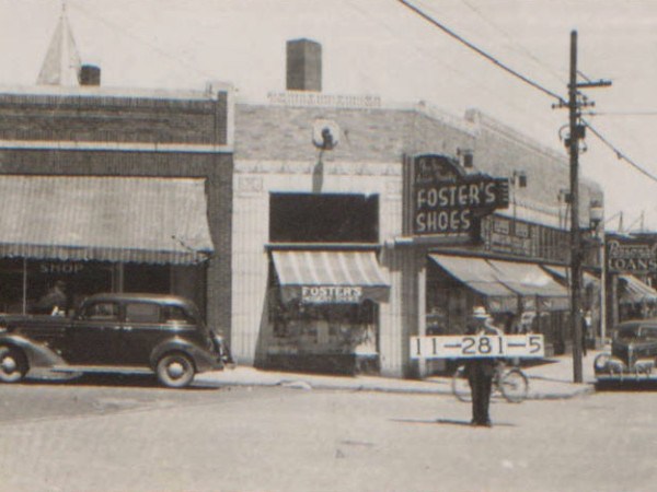
According to the 1940 tax assessment photos, the building housed Foster’s Shoe Store, seen below.
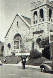
Another significant significant building at this intersection was the Hyde Park Christian Church, seen below in 1940.
.
This structure was constructed in 1905, yet was demolished in the late 1950s. The church’s activity relocated to 3801 Wyandotte. A structure of a similar footprint is evident from the 1957 Jackson County aerial. However, since the building’s destruction, no new structures have been erected in its place.
Furthermore, this stretch of the Main Street corridor is noted for other prominent demolitions. Throughout time, commercial structures that lined Main approaching 39th street have been destroyed to accommodate car-oriented uses (such as the CVS and surface parking lot at the southwest corner of Main and 39th street). Additionally, in the earlier 20th century, there was significantly more housing directly on or adjacent to Main Street. According to the 1925 Sanborn, a development known as “Weaver Place” contained 5 3-story apartment buildings. These appear to have been of the 6-plex brick typology commonly seen throughout Kansas City. Across the street, 12 2-story apartment structures lined 40th Street Way. These structures are evident in the 1957 Jackson County aerial, yet were demolished before the 1991 aerial. Presently, 40th Street Way is a one-way street with relatively little activity. Commercial uses and surface parking flank the formerly residential district on the north and south sides. Weaver Place appears to have been destroyed as St. Paul’s Episcopal Church expanded its institutional footprint in ensuing decades. This expansion included destroying the Rollins School, originally constructed in 1904.
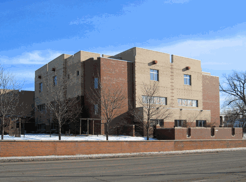
St. Paul’s Episcopal Day School erected a new structure on the site of the former Rollins building.
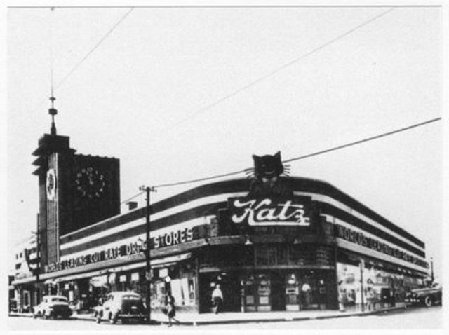
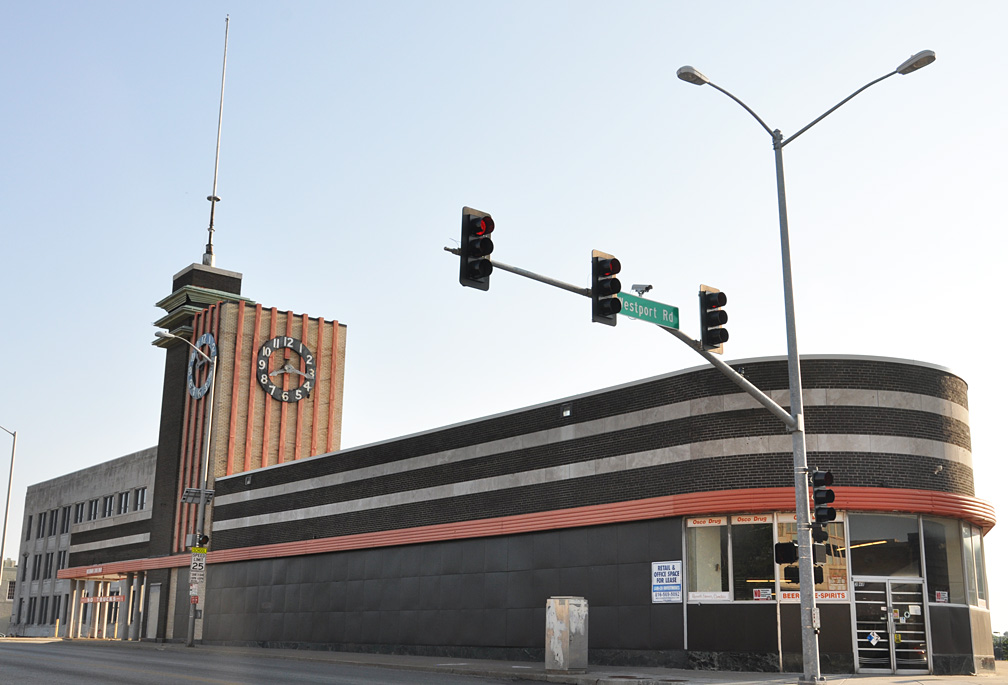
Another culturally significant change along the corridor involves the iconic Katz Drug Store at the corner of Westport Road and Main. Seen below in 1940, Katz’s personifies an Art Deco charm.
An Osco pharmacy most recently inhabited this structure. The structure has been largely vacant since 2006, however. Recently, art pop-ups have given new life to the vacant building.
Undeniably, this stretch of Main has experienced significant change throughout the decades. The preservation and adaptive reuse of the buildings that survived, however, has contributed to the charms of this Midtown area.
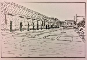
The Public realm is often defined as the space between the buildings. In this space is where people can walk, talk, meet, sit, and stay. There are certain design elements that benefit the Pedestrian experience, and some well intentioned design elements that failed. The issue of Human scale and continuity all contribute to the success or failure of an element. I choose to study the region of Main Street from 31st to 51st, including the next closest streets, Walnut and Baltimore.
Walls
“Walls are put up in the mistaken notion that they will make a space feel safer. They make it feel isolated and gloomy.” – William Whyte
Most of the walls along Main Street fulfill the Main Street Plan’s requirement for screening a parking lot but they fail to add to the overall experience of the corridor. The purpose of these walls is ideal to help maintain a street edge and create a sense of continuity. However, because of the change in materials and scale, the walls become confusing and inconsistent.
Fences
According to the Kansas City Urban Design guidelines and the Historic preservation guidelines, fences should be low and reflect the house style. This should be done to help preserve the original historic material. However most of the fences I came into contact with were overwhelmingly utilitarian and non-compliant with the design standards.
Bollards
Bollards are used to help provide a barrier between the Pedestrian realm and the Automobile. They provide a visual and Structural deterrent and range in type and effectiveness. The sacrificial nature of bollards allows them to stop vehicles and be easily replaced if necessary. There are many types of bollards, permanent, movable, lighting bollards, in various shapes and sizes.
Doing rapid analysis can yield some pretty great results. When a time constraint is given to you, not only do you work faster, but you are forced to edit down to whats important.
Our studio did 3 separate 3 hour studies of the parks and boulevards system. We looked at the system as a whole, history of many of the “knuckles”, and the planning, zoning and land use in said areas.
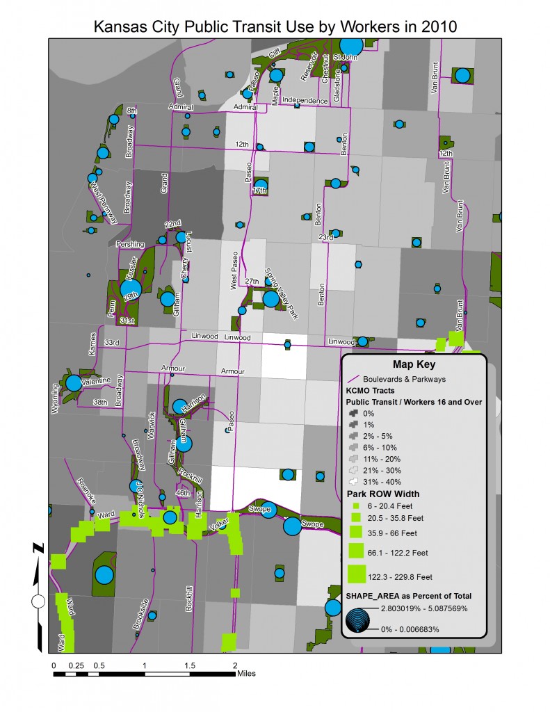
PUBLIC TRANSPORTATION WITHIN PARKS & BOULEVARDS
Data Gathering
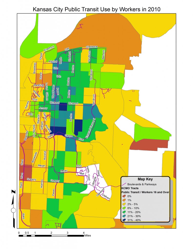
In order to study the relationship of public transportation and the parks and boulevards system in Kansas City, reliable data must be gathered and properly joined. The shape boundaries were taken from the 2010 Census Tract Boundary. The data fields that were used came from Social Explorer and included information from the 2008-2012 American Census Survey. Using commands in ArcGIS, the ACS data was joined to the Tract Boundary shape file and a data dictionary was used to rename specific fields.
The study boundaries for this analysis are from the Missouri River in the north, to the Blue River to the east, to 79th Street in the south, and State Line to the west. The New Park shape file and the ROW shape file were taken from the Parks and Recreation department from Kansas City, Missouri.
Process and Mapping
By using symbology, several things were able to be visually represented within the boundaries. The first thing that was vital to the map was a visual description of where people that use public transportation are. This was done by normalizing the (amount of workers who use) public transport data by the overall amount of workers. Another tool that was used were the shapefiles that show were the ROW parks and new parks are located.
By using symbology techniques, the ROW width was calculated by using a calculation of the area divided by the length of the polygon, the result was the width of the actual ROW. I then presented these sizes in an exaggerated rectangular green shape. The New park data was illustrated by showing the area of each park normalized by the total size of all the new parks. These were shown with blue circles whose size reflects the park size compared to the overall parks.
Analysis
There are several patterns that emerge when studying the maps that were created for this analysis. The first is that the majority of public transportation activity is located east of Troost and north of Emanuel Cleaver II/ Volker Parkway. There are census tracts that have 30% – 40% of its workers using public transportation to get to work. For all of Kansas City, MO there is a MEAN AVERAGE OF 6% that use public transportation, A MEDIAN OF 3%, and a STANDARD DEVIATION OF 8%. The AVERAGE WIDTH FOR THE PARK RIGHT OF WAY WIDTH WAS 42 FEET.
ROW’s tend to be in areas where there is low public transportation. When looking at the relationship between the amount of park space and ROW to the use of public transit, it can be seen that the areas using public transit the most, lack the most availability to the parks and boulevards system.
Design Strategies
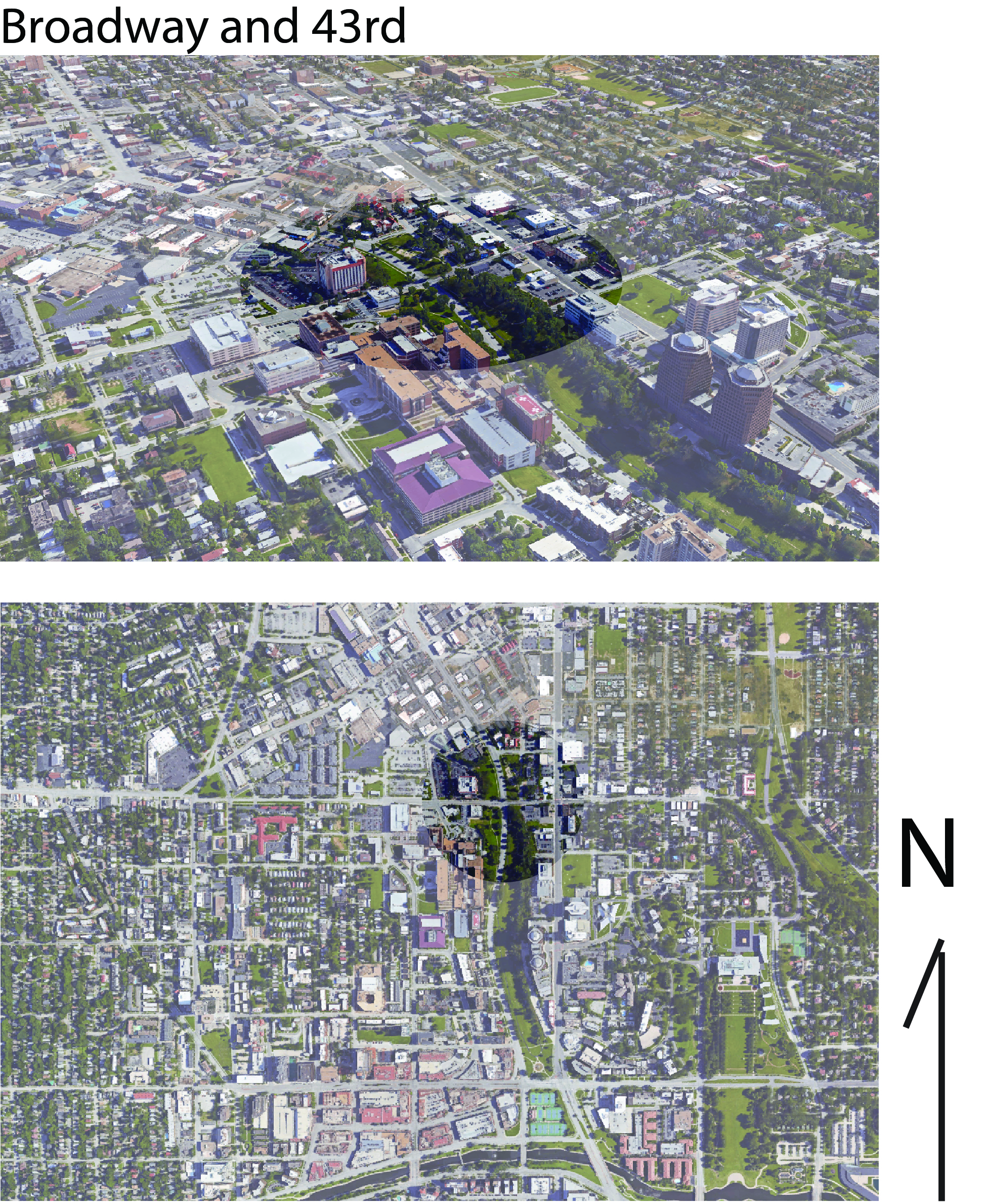
History
There are several noticeable changes that have happened at the intersection of Mill Creek/Broadway/ JC Nichols and 43rd street. The area in the parks and boulevard system is near the plaza and Westport. Up until the 1990s there was a railway bridge Westport area.
Changes
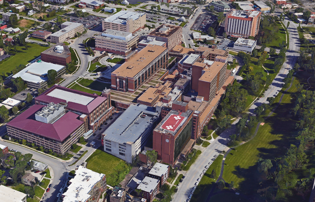
There is a vast change in several things besides the lack of a railroad. The street grid is completely altered. St. Luke’s hospital has changed the transit ways around the intersection and there is an almost completely different building foot print as well.
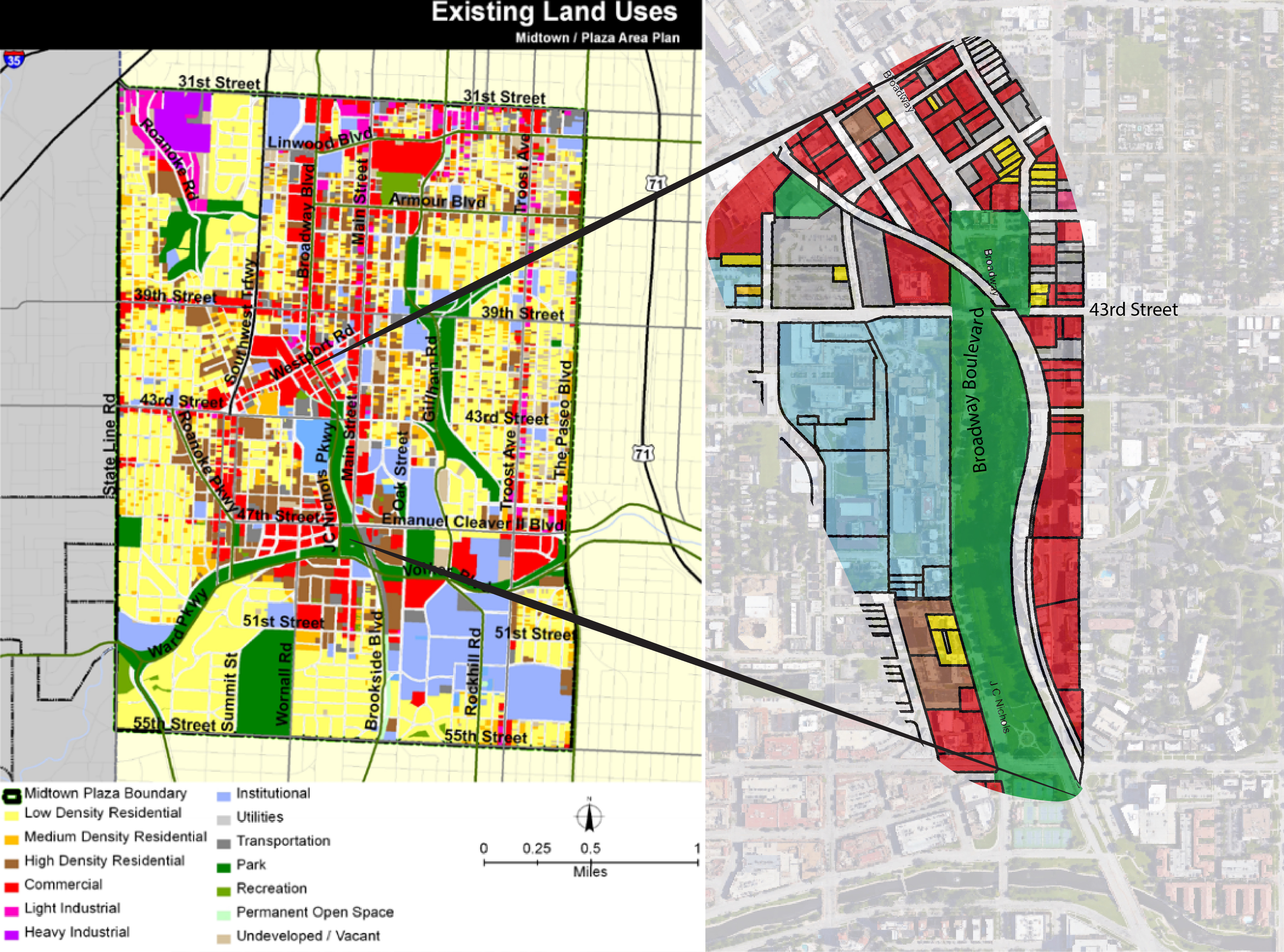
Land Use
The Midtown and Plaza Area have a very complex mix of land use. There are large areas of residential neighborhoods surrounding a mix of commercial businesses and institutional areas. The “knuckle” of Broadway Blvd/ JC Nichols and 43rd street represents this mix of land use that is characteristic of the general area. St. Luke’s represents a large institution and the location is also where the two commercial sectors of the Plaza and Westport collide. Running through all of this is Mill Creek park — the large green space that serves the many neighborhoods in the surrounding.
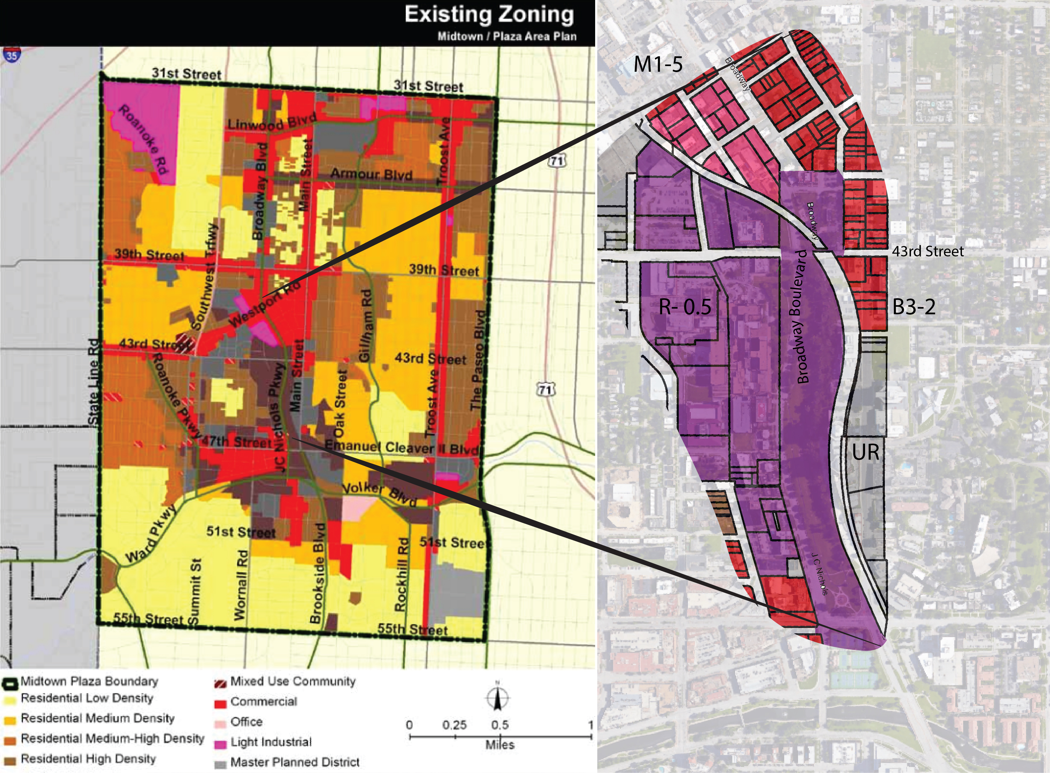
Zoning
The area has several zoning uses that are representative of the mix of zoning that is in the overall area. To the west of Broadway there is a large span of Urban Residential zoned land. To the east there is a Urban Redevelopment zoned area that spans along Main Street. To the north east of the intersection there is a commercially zoned area. As Broadway curves to the North West the zoning along the west side of the street is light industrial.
Other Plans and Land Use Conflicts
St. Luke’s Hospital is a large institutional land use that has expanded its size greatly in recent years. The zoning in the area is R-0.5 which is residential urban.There are other conflicting plans that institutions and neighborhoods have created. Southmoreland has developed an area plan and the Nelson has been working to develop a cultural district in the area.
Resources
Data was gathered from several sources including Google Maps, Google Earth, Midtown/ Plaza Area Plan by the planning department of Kansas City MO The Nelson Atkins Museum of Art Cultural District Plan, and The Southmoreland Area Plan
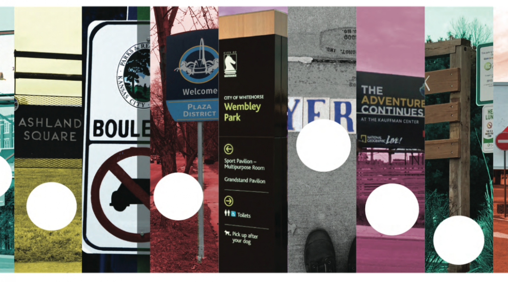
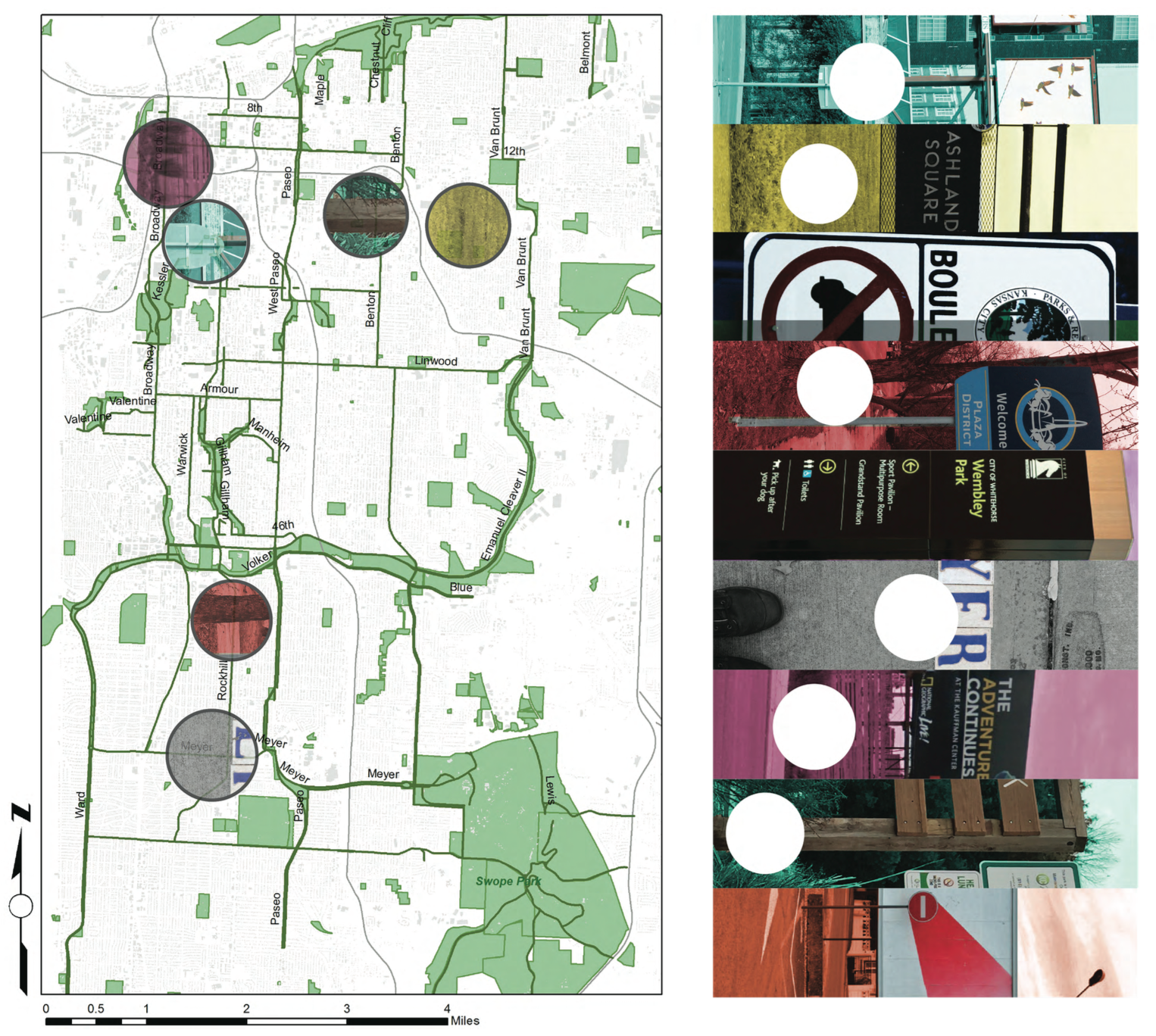
This map shows the relative locations of different kinds of signage that line the parks and boulevards system in Kansas City.
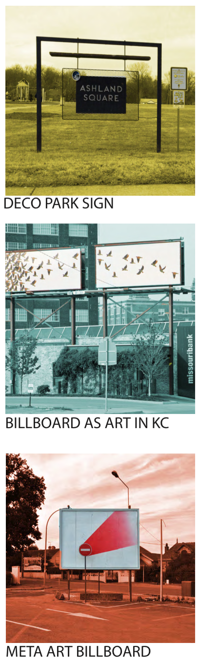
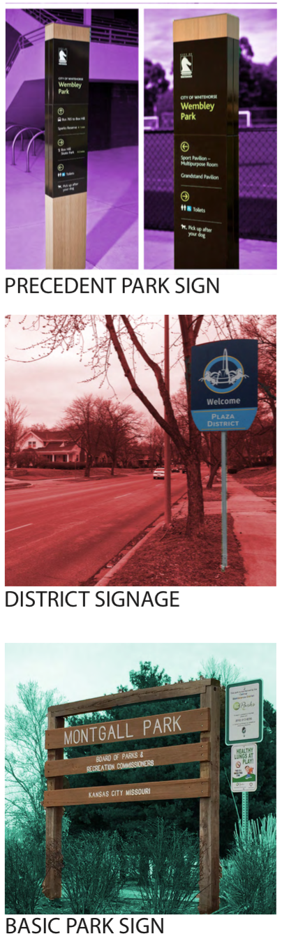
PRECEDENTS OF SIGNAGE ON PARKS & BOULEVARDS
There are a wide array of different kinds of signs in KC. I took as many examples that are representative of the different aspects of this design element.
IMPLEMENTATION
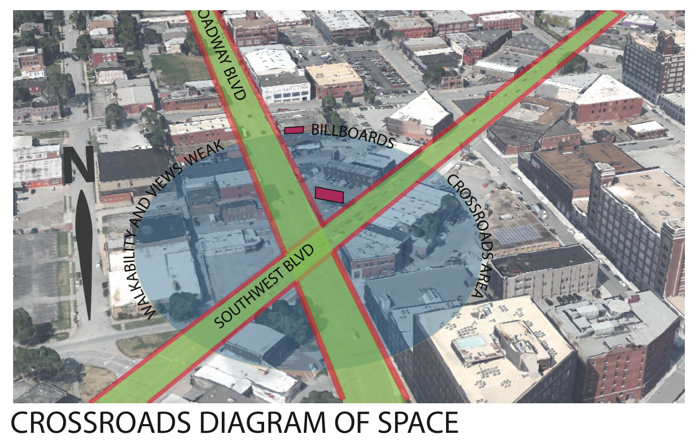
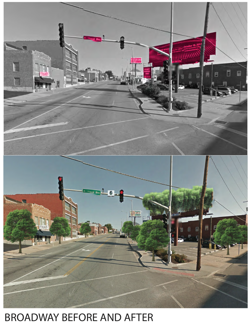
When diagraming the intersection of two famous boulevards in KC I noticed the importance of the crossing. As Broadway and Southwest Boulevard meet, there is an opportunity for a walkable route that could connect people throughout the crossroads. Currently, the billboards create a very impersonal scale for the pedestrian and also are an inherent negative externality to the passerby.
By implementing vegetation along the streets and restoring the streets to exemplify their namesake, the intersection takes upon an entirely different feeling. I also envisioned having a elevated garden green area where the billboard platform currently resides.
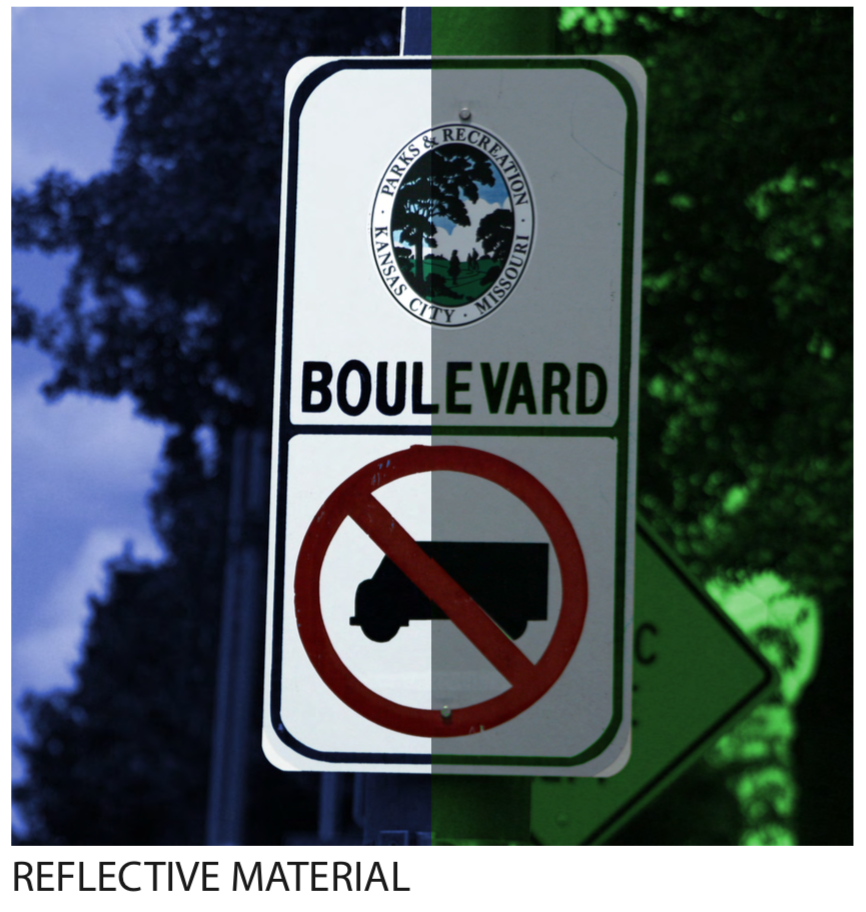
By increasing the brightness and adding a reflective material to new boulevard street signs, the information becomes much more readable.
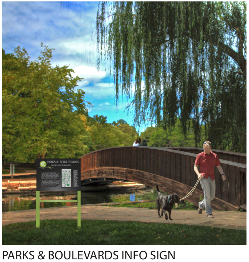
One of the things that I noticed through analysis and study of the Parks system is the lack of a design language. There also is a surprising lack of information and history that is shared in the public physical realm. I, in turn, envisioned a coherent and consistent park sign that could carry information, context, and history of the parks and boulevard system. People want to know about Kessler, and how the parkways and boulevards follow the topography, interconnecting the park “knuckles” dispersed around the city.
It’s not as simple as installing nice park benches (though that’s part of it)
In last week’s posts, my studiomates and I — having just been “introduced” to the system earlier in the week — posted our “first impressions” of Kansas City’s fabled Parks and Boulevards system, the focus of this semester’s design studio.
As was pointed out in those posts, half of us are from here and have been in contact with the system at least on and off all our lives: we weren’t posting our “first” impressions, more our understanding of the system based on a couple decades of experience.
But regardless of whether we were native Kansas Citians or not, a certain theme appeared in most of our posts last week. We each generally focused on a particular part of the system — usually, a specific park we had visited recently or were familiar with. The sites we were studying were different, our perspectives were different — and yet a theme emerged: that Kansas City’s parks and boulevards aren’t living up to their potential.
It was a sobering conclusion: that one of our city’s most distinguishing physical features isn’t fulfilling its function (and this finding was compounded by the realization that we each found the same thing). Parks are meant to have people in them, right? Yet, there were few — sometimes no — people in any of our studied parks. Boulevards, a somewhat trickier feature to study and measure the success of, certainly were driven on, we found — but we also saw that a whole other dimension of amenities offered by boulevards beyond their attractive landscaping — including shelters, monuments, open areas for sports — seemed to have been lost on Kansas Citians.
So what’s the problem? There was some chatter among us that, well, maybe it was the weather — we had initially visited our parks on a chilly January day, after all. But then some of us got back out on an unseasonably warm day later in the week and essentially saw the same. Maybe it was the time of day, or the fact we surveyed mostly on weekdays — even the best park’s going to have some ebb and flow. But over the last week, we’ve gotten out at various times of day, and even over the weekend, only to find most parks mostly empty. (And anyway, some of us were basing our judgement on years of observation and experience of these parks.)
No, for these underused parks, it seems there has to be some environmental characteristic of them — or possibly of the city around them — that was keeping people away.
The status quo of KC’s parks? Well-maintained, spacious, but empty? (Mill Creek Park at lunchtime, 1/26/2015.)
A Kansas City Specific Problem?
Of course, we can all picture well-used parks. My mind jumps to parks I’ve experienced while visiting bigger cities — Chicago, Montreal, and recently in Buenos Aires. As a Kansas Citian, some of these places were striking in how busy they were: so many people, young and old, doing all kinds of things — playing on swingset, throwing a frisbee, jogging, sitting, or just walking through.
Obviously, there are examples of well-used parks here. Everyone’s been to Loose Park. Mill Creek Park, with it’s horse fountain in the shadow of the ever-popular Plaza, is busy on balmy weekends and even weekday lunchtimes. A certain part of Gillham Park gets packed on a nice weekend day. Penn Valley and Swope Parks will usually have some kind of traffic on the weekends, regardless of weather (though these are regional parks, and I’m concerned here with smaller, more “neighborhood-oriented” parks).
But those are really just a handful. The Kansas City Parks and Boulevards System comprises “12,000 acres of parkland including 220 parks,” according to the parks department (2014). (That’s about 26 acres per 1,000 residents, which is about the median for US cities of our size [Trust for Public Land, 2011].)
Kansas Citians do seem to care about their parks system as a whole. In 2012, residents passed a sales tax dedicated to the maintenance and expansion of their parks system — this funding had previously just come from the property taxes funneled through the City’s General Fund.
So it’s not lack of interest that keeps so many KC parks empty. It’s not oversupply of park. And it’s not their condition — most parks here are very well kept. So, in short, it doesn’t appear to be something about the city, its residents, or the parks system as a whole that’s responsible.
Meanwhile, let’s keep in mind that even in cities with really great parks — Central Park, Millennium Park — there are always forgotten, empty parks.
So then, it’s not necessarily a Kansas City-specific issue — all cities can struggle to fill their parks.
That raises the question, then — what is it that makes a great park? Can we identify particular elements of urban and park design that lead to a busy park?
What makes a great park (or boulevard)?: The Jacobs/Whyte Formula
Luckily for us, we can turn no further than to the great Jane Jacobs for some answers. She devotes a chapter of her seminal Death and Life of Great American Cities (1961)to “neighborhood parks” (so, again, not regional attractions like Swope or Penn Valley).
Actually, though, Jacobs may not be the most prominent figure in the study of parks in the US — William Whyte, founder of the discipline of urban psychology, put together a widely respected analysis of parks in New York City that was turned into a film, as well as a chapter of his 1988 City: Rediscovering the Center (1996, 483).
Combine Jacobs and Whyte’s work and you end up with a powerful rubric for analysis a city’s parks.
Jacobs: “Diversity”
Jane Jacobs was all about upending conventional thinking about cities and urban planning of her era. In the Death and Life chapter entitled “The uses of neighborhood parks”– well, she might as well have stopped writing after the first two sentences:
Conventionally, neighborhood parks or parklike open spaces are considered boons conferred on the deprived populations of cities. Let us turn this though around, and consider city parks deprived places that need the boon of life and appreciation conferred on them. (1961)
Walk-off homerun, right there.
Basically, Jacobs says that parks are often created to become site of diverse activity with a diverse group of residents. Yet, she argues, what makes a park successful in this way is diverse activity already happening in the area. A vibrant, successful park, in other words, comes from a vibrant, successful neighborhood — not the other way around.
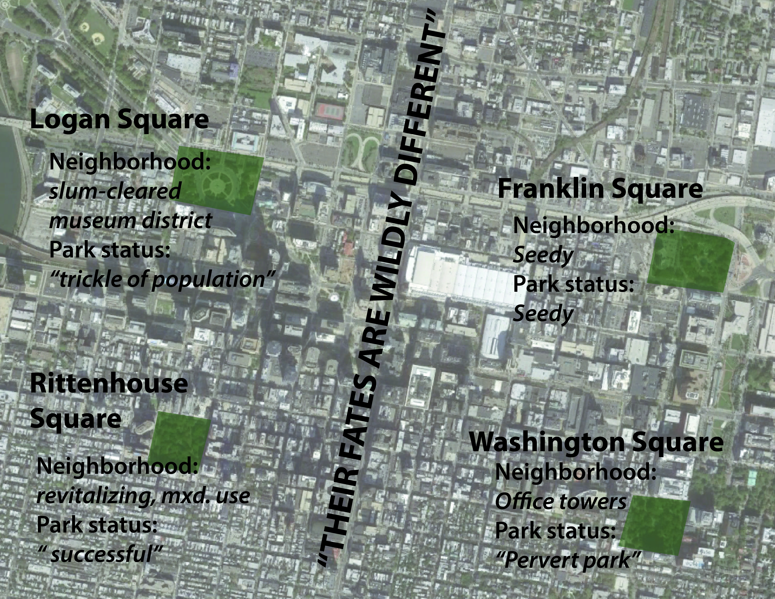
Jacobs uses a set of very similar parks around downtown Philadelphia for a sort of experiment to test this hypothesis. She explains:
Philadelphia affords almost a controlled experiment on this point. When [William] Penn laid out the city, he placed at its center the square now occupied by City Hall, and at equal distances from this center he place four residential squares. What has become of these four, all the same age, the same size, the same original use, and as nearly the same in presumed advantages of location as they could be made?
Their fates are wildy different. (1961 p?)
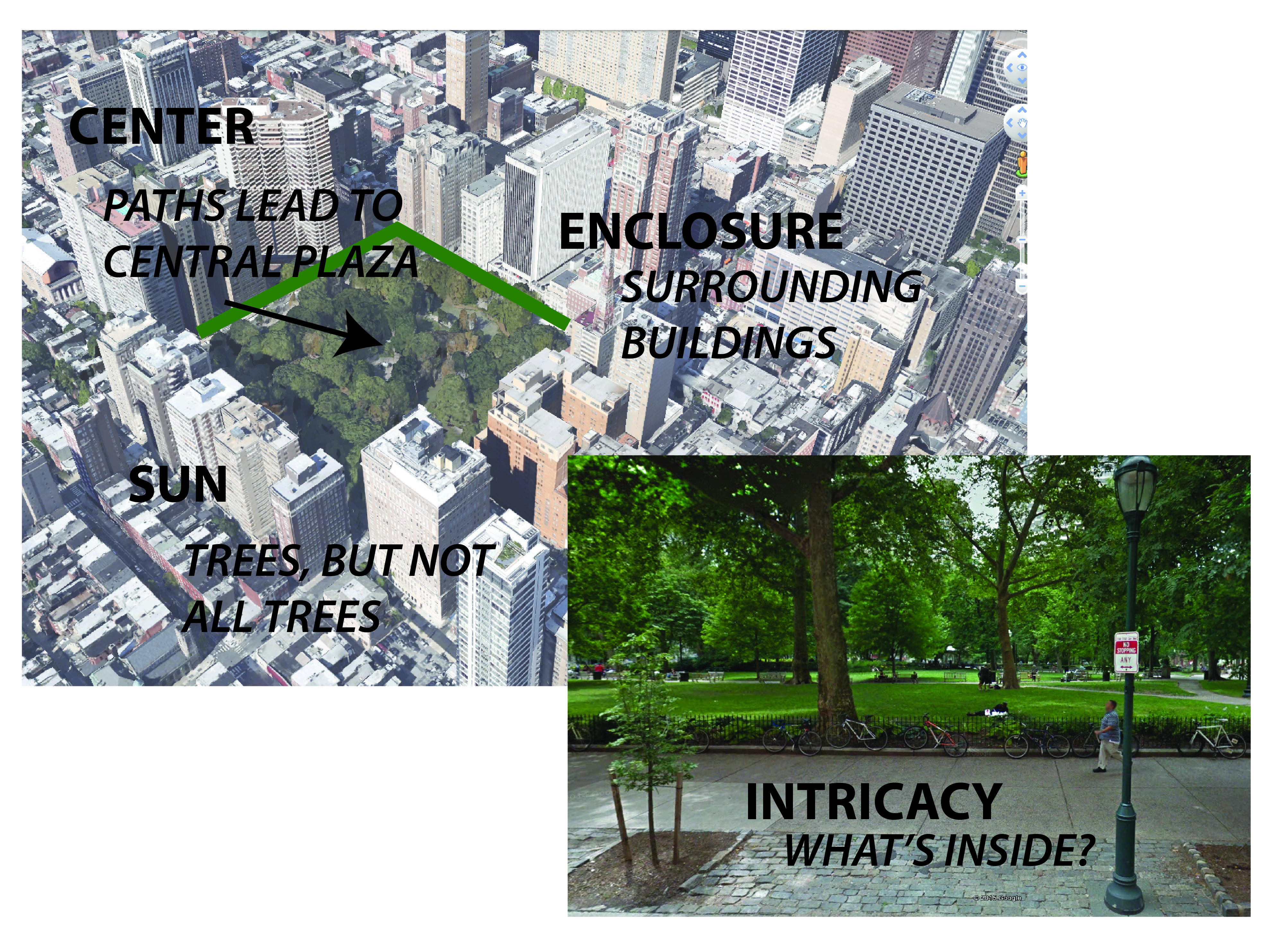
The four squares, basically copies of each other, turned out differently based on the conditions in the neighborhoods immediately surrounding them. The figure below summarizes her findings:
The results of Jacobs’ experiment. Squares of the same size, age, and of similar design are strongly effected by their surrounding neighborhoods. Map source: Google StreetView
Jacobs essentially says that a park — after all, a relatively passive place — will mirror its surroundings.
And key to the continued success of a park is not only the quality of the neighborhood around it — whether it’s a “good” or “bad” place — but it’s also diversity of uses in the surrounding neighborhood that’s important too.
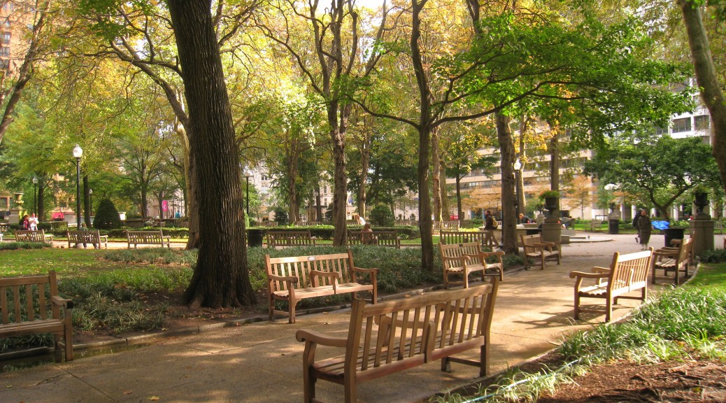
As Jacobs describes 1950-60’s Downtown Philadelphia, the areas around Rittenhouse Square and Washington Square are prominent, busy district — the latter is home to high-profile commercial office towers. The difference between the two is the degree of diversity in activity. Rittenhouse Square has around it, not only residences but “an art club with restaurant and galleries, a music school, and Army office building, an apartment house, a club, an old apothecary shop, a Navy office building… (1961 p?)” The list goes on.
What does this mean for the park? “This mixture of uses of buildings directly produces for the park a mixture of users who enter and leave the park at different times.”
And Washington Square? “Its rim is dominated by huge office buildings, and both its rim and its immediate hinterland lack any equivalent to the diversity of Rittenhouse Square — services, restaurants, cultural facilities. (1961 )” Consequently, the only significant population who would use the park are office workers from the surrounding buildings, describes Jacobs, and they are only free at lunchtime. And the relative “vacuum” of space that is created is filled by undesirable characters who end up scaring a lot of the office workers off altogether. This park, now known as Washington Square Park, shares some eerie similarities with Kansas City’s park of the same name near Crown Center.
“Design:” Whyte (and Jacobs, too)
I was prepared to set Death and Life down and begin work on my final project right then, after reading the results of Jacobs’ Philadelphia experiment: the “diversity” explanation seemed so spot on.
And there’s nothing to suggest that Jacobs was anything but spot on there. But even she added some detail to what makes a great park — this time, focusing on the specific design elements of a park. After all, the most vibrant neighborhood around just a plot of mowed grass probably wouldn’t make for the best park.
Jacobs defines four elements integral to the success of a neighborhood park:
1. Intricacy: A complex, interesting plan. “[C]hange in the rise of ground, groupings of trees, openings leading to various focal points… (1961)”
2. Centering: A well-defined center point, something that pulls people into and/or through the park. Jacobs criticized “[l]ong, strip parks” especially for generally lacking a center, which she says leads to confusion among park users as to where they should go.
3. Sun: A balance of sun and shade. Too much open space exposed to the sun without trees for shade is bad; so is a giant, chilly shadow cast by a building.
4. Enclosure: Usually by surrounding buildings, making a “definite shape out of the space, so that it appears as an important event in the city scene… (1961 )”
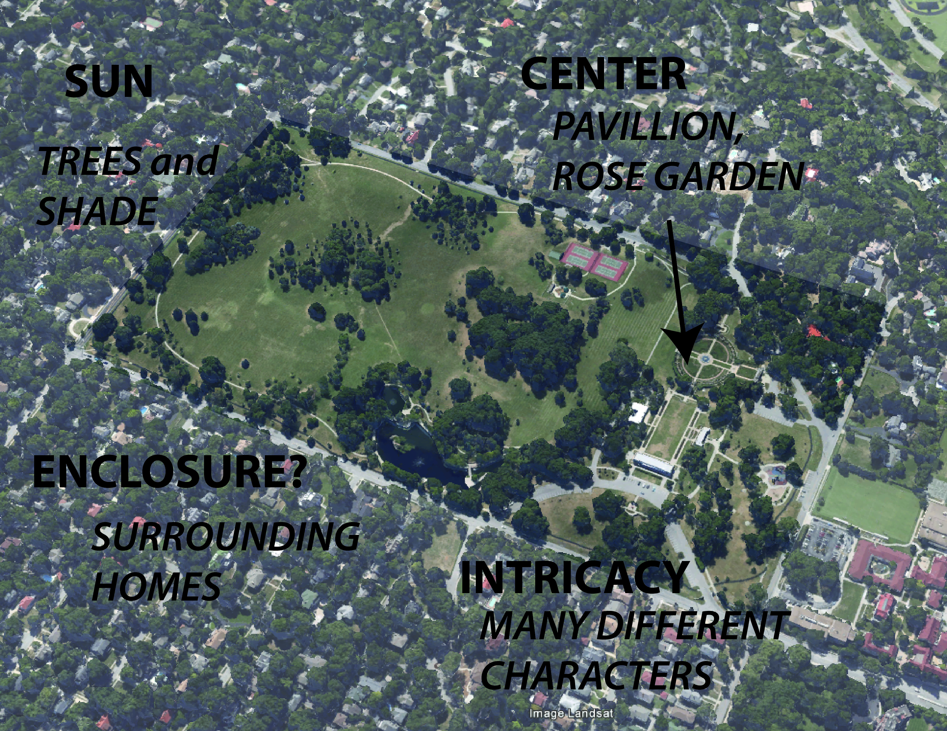
Rittenhouse Square embodies these four characteristics.
Jacobs’ four criteria for good neighborhood parks as seen at today’s Rittenhouse Square. Map/photo source: Google Earth/StreetView
A mixture of two or three of these criteria could be attributed to Kansas City’s best parks (most are probably going to lack strong “enclosure,” though, due to our low density). Loose Park has intricacy, centering, and a good mixture of sun and shade (and some enclosure). Gillham Park has intricacy, sun, and even enclosure. (Penn Valley and Swope Park, while popular, aren’t exactly neighborhood parks, so it’s unsurprising they defy Jacobs’ standards, lacking centers and enclosure and just being somewhat chaotically organized.)
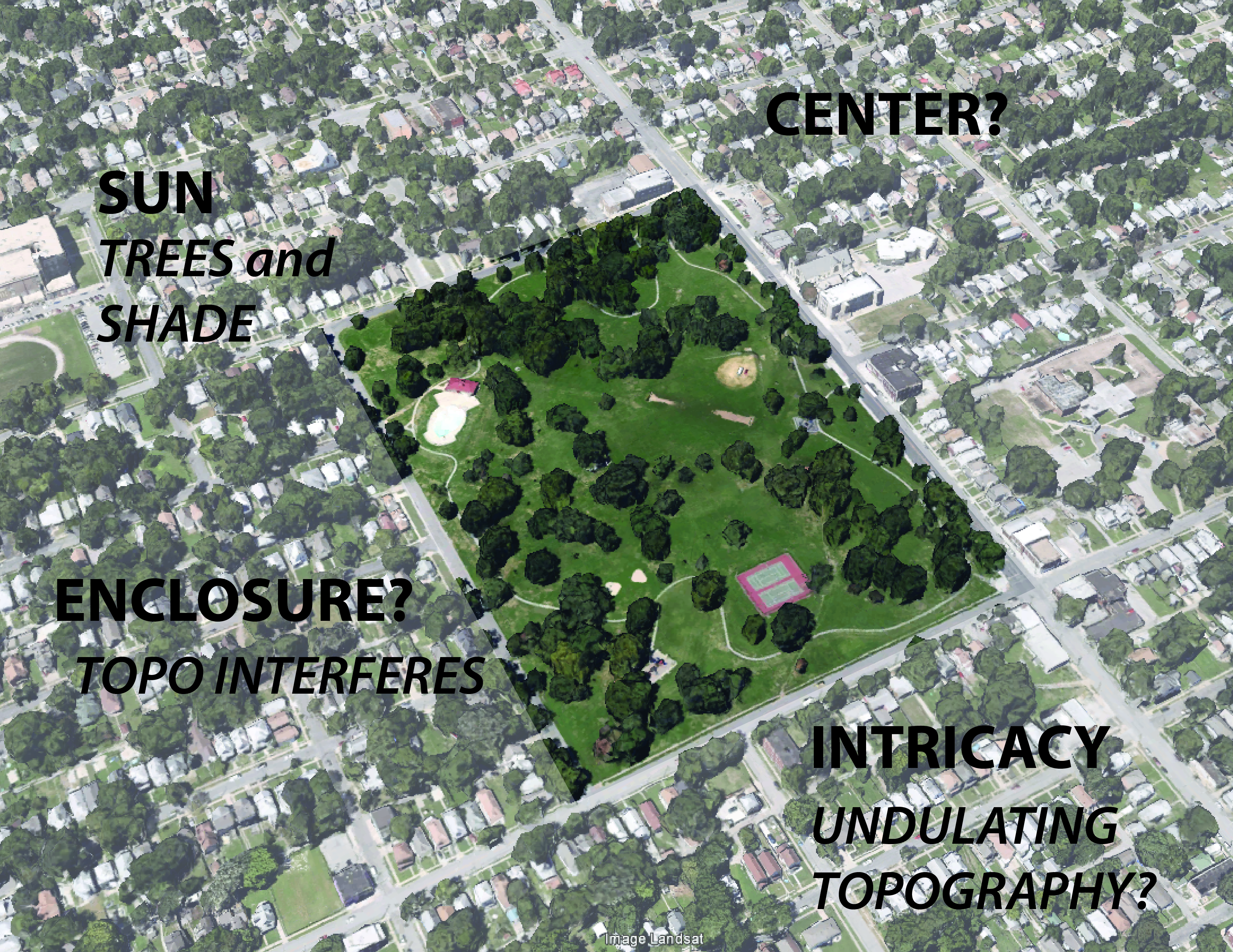
Jacobs’ criteria applied to Kansas City’s Loose Park, possibly explaining the park’s success. Map source: Google Earth.
Most parks in KC, though, are missing most of these elements. Many parks, lacking intricacy, can be taken in with a single glance, usually consisting of an open, uninspiring lawn, with maybe a path or playground on the edge. An that focus of elements on the edge — probably to be near parking — leads to a lack of centering of anything (except the lawn?). Addressing the sun may be what Kansas City’s parks do best, but even some parks lack trees or shelters at all. Very few parks here are enclosed, and many just melt into their surroundings, never declaring themselves as a distinct destination; some parks are defined by a line of distant trees along their back edge, but that effect is actually somewhat unsettling (what’s lurking there?).
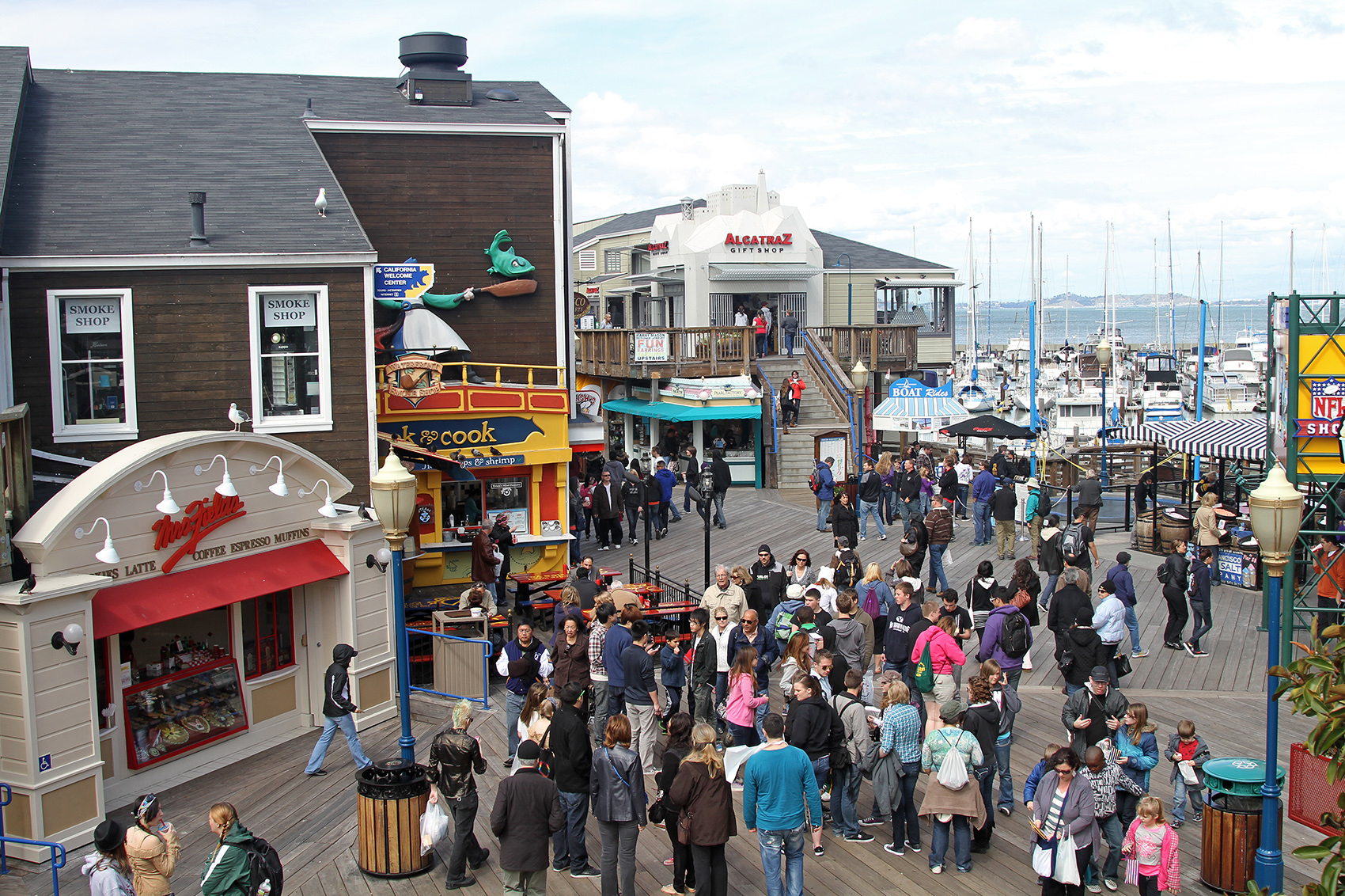
Jacobs’ criteria applied at Budd Park. Sun is addressed, some intricacy could be attributed to the undulating topography, but other element are problematic. Sense of enclosure (definition of park boundaries) is defeated by the rolling terrain; there’s no center or even just a main node. Map source: Google Earth.
Jacobs’ design criteria, seem, on the surface to explain the popularity (or lack thereof) of Kansas City’s parks. But really what’s that different about Loose Park and Budd Park? Is Loose’s Rose Garden and pinic pavillion enough to attract that many more people?
William Whyte’s design standards for good park space mostly affirm Jacobs’. His survey of New York City plazas in the 1970s found the most popular created visual interest (intricacy) with multiple levels, stairs, fountains, etc.; they got a good mix of sun and shade; they had centers, or at least defined nodes; and they had defined edges.
Whyte added several new findings to the understanding of park spaces, though. He and his fellow researchers, intricately mapping the flow and displacement of people in public spaces in New York City in the 1970’s, established two key patterns. First, they found that some of the most popular plazas were the most central, located closest to the largest office buildings. (This dovetails to some extent with Jacobs’ “diversity” argument.) Whyte qualified this, though: “Our initial study made clear that while location is a prerequisite for success, it no way assures it. Some of the worst plazas are in the best spots…. (486)”
The absolute defining factor, though, was the amount of sittable space in a plaza: “People tend to sit most where there are places to sit (487).”
And, in fact, more so than really any parks in Kansas City, two of the city’s most popular parks — Loose and Mill Creek Parks — or rather, the most popular parts of these parks are both centrally located in the city (near the busy Plaza) and they offer plenty of places to sit. At Loose Park, there’s the pavilion, the Rose Garden, each with plenty of benches; at Mill Creek Park, benches surround the iconic fountain at the south end of the park, and plenty of people just take a seat on the fountain’s generous rim. Many people walk to these parks — though most probably still drive.
But if all of this is the formula for good parks in Kansas City, the city soon starts to complicate things by introducing another element to its parks system: boulevards.
Boulevards
Jacobs’ and Whyte’s rubric might not, at first look, seem to be applicable to the spaces created by Kansas City’s numerous boulevards and parkways. (How can you even define a center/node for a street?)
Actually, though, Kansas City’s boulevards do meet many of the design criteria defined by Jacobs: To some degree, they create enclosure and intricacy, and manage sunlight well.
What they usually lack is the surrounding diversity of uses that Jacobs claims made Rittenhouse Square work so well: KC’s boulevards, after all, run through chiefly residential areas.
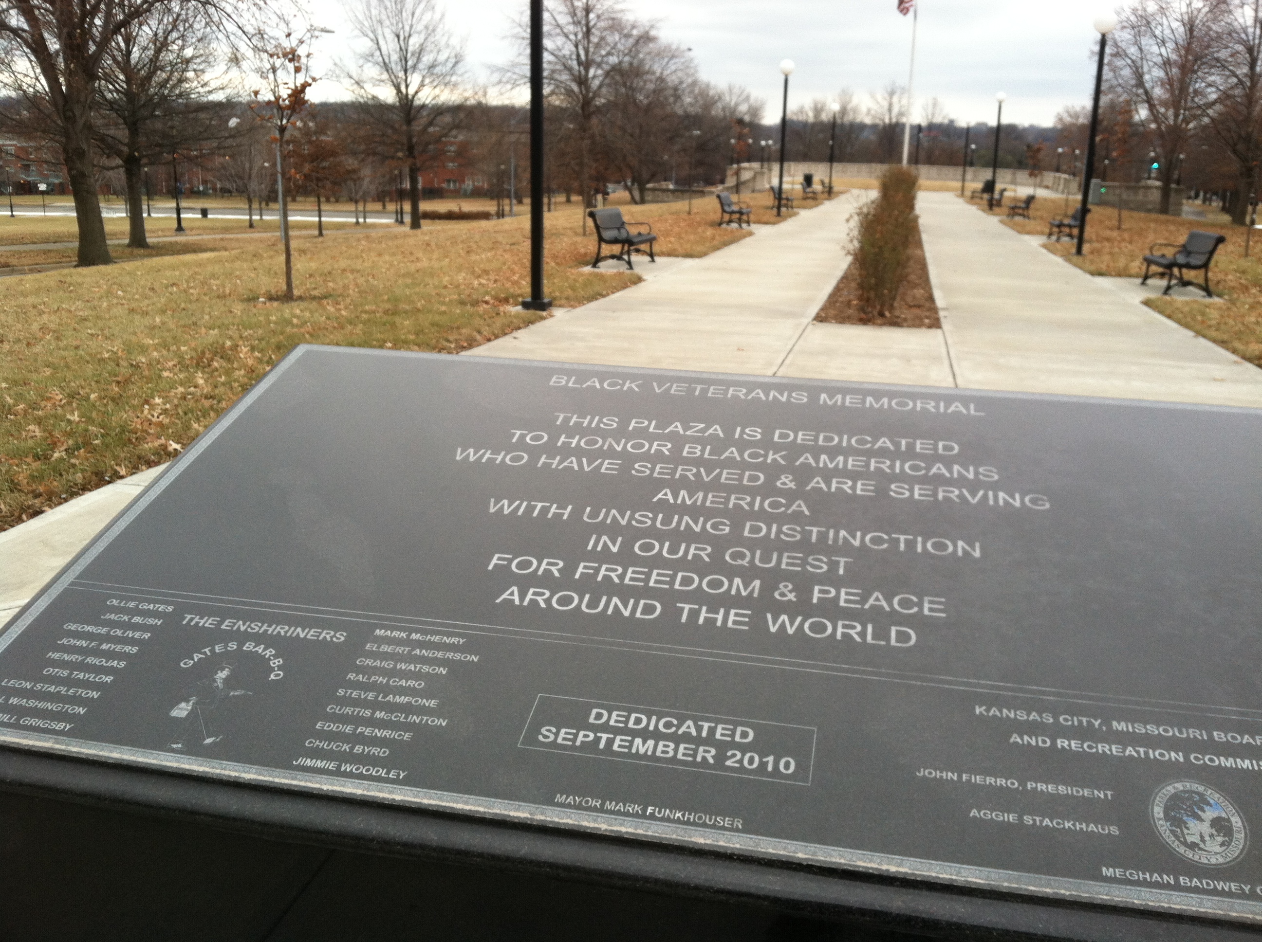
Meanwhile, Kansas City’s boulevards do not generally offer a place to gather, or just to be in. There are no places to sit. (Rare exception: The Black Veterans Memorial, in the median of Paseo near 9th St. Problem: lack of surrounding diversity of use.) Boulevards are places to drive or walk through, moving from an A elsewhere to a B still somewhere else.
Another notable “Jacobs” involved in planning research, HB Jacobs, provides a possible alternative for Kansas City’s boulevards. Jacobs wrote a compendium of great streets from around the world, aptly entitled Great Streets (1995).
Unter den Linden, Berlin. Source: Google StreetView.
One example he illustrates, that of Unter den Linden, a boulevard in central Berlin, checks all the boxes in the Jacobs/Whyte rubric: a diversity of uses is evident in the mixed-use building on the left in the photo above; expand the photo, and you’ll see that benches line the edges of the central median; meanwhile, the boulevard’s central location in the city probably helps make it successful. ( Jacobs adds: “The lindens are uniformly, 8 meters apart; the smell is beautiful, a reason to go there (148).”)
Ward Parkway, the median of which looks about as wide as Unter den Linden’s, will never look much like this photo otherwise.
What it — along with Paseo, Broadway, Benton — could become that is like the Unter den Linden above, is more of a place for people. That doesn’t mean tearing up all the grass in the median and verge for gravel pathways — but it could mean adopting some of the design elements I’ve already discussed. How about benches placed in the medians at major intersections with other streets? It would be a start. And where our boulevards do, in fact, mix with diversity of use — like, along much of Broadway Boulevard — sidewalk seating for likes of restaurants and cafés is not only doable, it seems imperative to attracting people to simply be in the street. The real challenge: Turning these lessons into action in KC
In truth, a lot of what Jacobs and Whyte discuss seems to not be applicable to Kansas City. We’re not Philadelphia or New York. Few of our parks are the squares discussed by Jacobs or the plazas surveyed by Whyte. We could never live up the sketches of European boulevards in HB Jacobs’ Great Streets.
Yes, our parks (and boulevards) are somewhat different creatures.
But the theme common to the great examples of planning/urban design I’ve shared here is that those spaces are made for people to be in. And the reasons they attract people — a center node, plentiful seating, well-defined edges, etc. — still seem to ring true.
That implies many of Kansas City’s parks — which lack these elements — could use a redesign.
The most elaborate overhaul of our city’s parks wouldn’t matter, though, if we didn’t a better job of putting parks where people are. But then, remember — parks mirror their surroundings: safe, vibrant parks will only exist in safe, vibrant neighborhoods.
And if that’s accurate — well, we have a lot of work to do in Kansas City, and parks really become the least of our worries.
References
Jacobs, HB. 1995. Great Streets. Cambridge, MA: MIT Press.
Jacobs, J. (1961). Death and Life of Great American Cities. New York:Random House.
KCMO Parks & Recreation Dept. (2014) “About KC Parks.” KCParks.org. From http://kcparks.org/about-kcpr/
Trust for Public Land (2011). 2011 City Park Facts. PDF. From https://www.tpl.org/sites/default/files/cloud.tpl.org/pubs/ccpe-city-park-facts-2011.pdf.
Whyte, William H. “The Design of Spaces” as reprinted n LeGates and Stout’s (1996) City Reader, NY: Routledge.
Last summer I had the opportunity to travel to California for several weeks. My sister and I spent time driving up and down the coast of central California exploring the landscape and more than anything — attempting to feel the environment. We decided that we would like to go to San Francisco for a couple of days before we had to return to home, so we booked an AirBnB in a reasonable part of town and took a bus out to the city. My family and I had traveled to San Francisco twice before and both times were entertaining, yet this time was different.
In the past we had drove to each landmark in the city and done the pre ordained activity. Yet on this trip we skipped the Pier, Chinatown, and the stone fortress island of Alcatraz and focused on what it meant to be an active member of the city. Our host at our room share informed us of activities and areas to check out that you wont find in any tour guide pamphlet and my sister and I set out on our journey. As we walked the city, we began to notice that this was not the same San Francisco that we had been to twice before. Everywhere we turned there was something different, yet something the same. The streets were the destination.
“Are we having fun yet?” Fishermans Wharf (Source: Google Image)
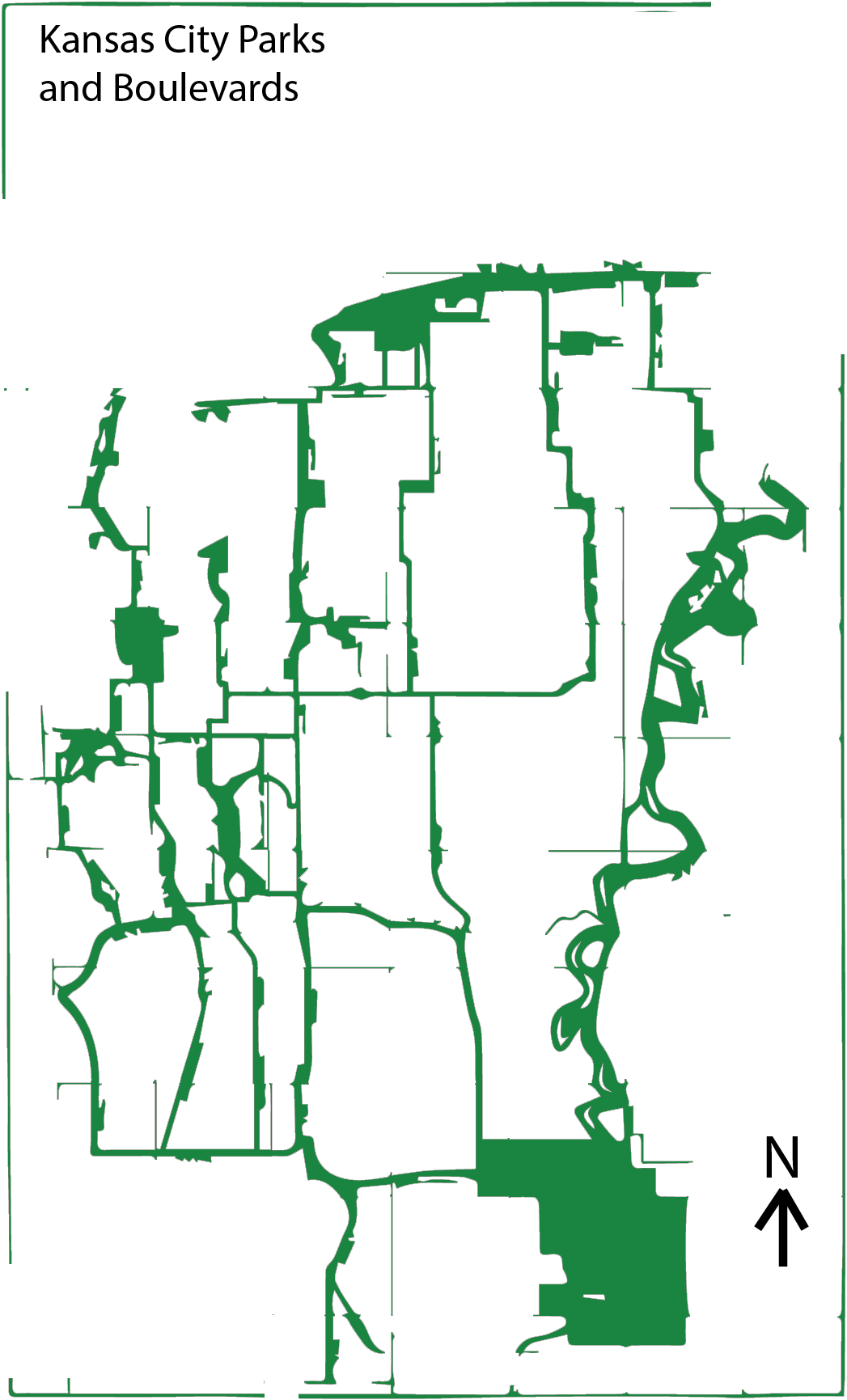
Illustration of the Parkways, Boulevards and Parks in Kansas City, MO
Our city was once like many other river cities of its type, dirty, pragmatic and some might even say ugly. As it expanded from the river, the gridding and subdivision of plots expanded south towards the undulating mounds of what now is Kansas City, Missouri. As man conquered new lands, there was often a manifest destiny mindset of forming our world to our whims. Yet, when George Kessler began to implement a new idea in the early 20th century, things began to change.
As a result of the City Beautiful movement, a progressive network of Parks and Boulevards was developed and constructed. These winding tree lined boulevards and parkways took full advantage of the natural topography of Kansas City. Instead of carving straight paths through the hills, the streets that Kessler help to implement curved back and forth creating a network of interlocking streets that lead the passenger through beautiful parks and vistas.
Characteristics
There are several defining characteristics that differentiate the Boulevards from Parkways. The Boulevards generally follow the gridiron of the street system whereas parkways may follow creeks or the natural topography of the city. While there are some exceptions — parts of The Paseo and Meyer – most boulevards don’t have medians in them. Parkways generally have large medians where there is space to play and back in older times, room to park. Boulevards are also very symmetrical and while parkways are sometimes symmetrical in certain areas, they are generally asymmetrical as they wind around the curves of the land.
Topography of the Parkways in the Plaza
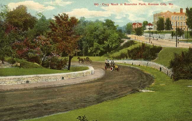
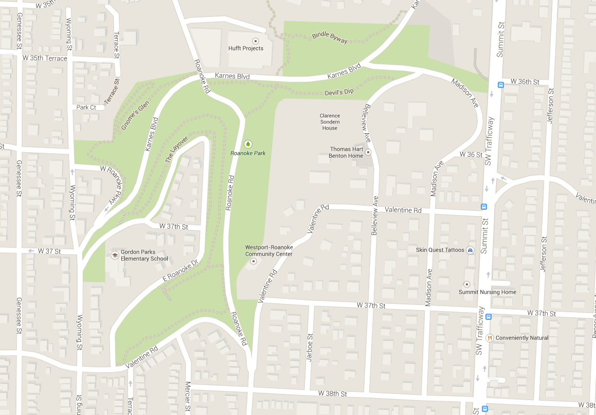
Roanoke Parkway and Park
Roanoke Parkway is disparate from the Roanoke Park. The short parkway is essentially a straight road that connects Westport Road diagonally to 47th street in the Plaza. The video shows a sped up journey one would take going north-west. There are apartment buildings that line the street on either sides and the street is lined with beautiful trees and the setbacks from the street allow a wide view when traveling by foot along the road.
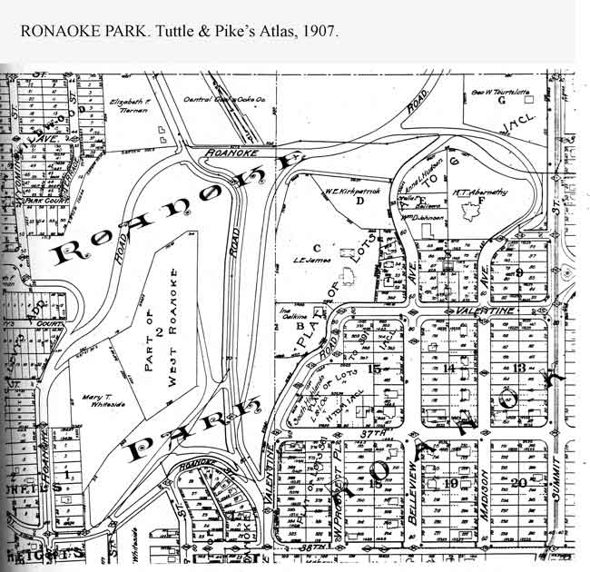
1907 Atlas Plan of Roanoke Park
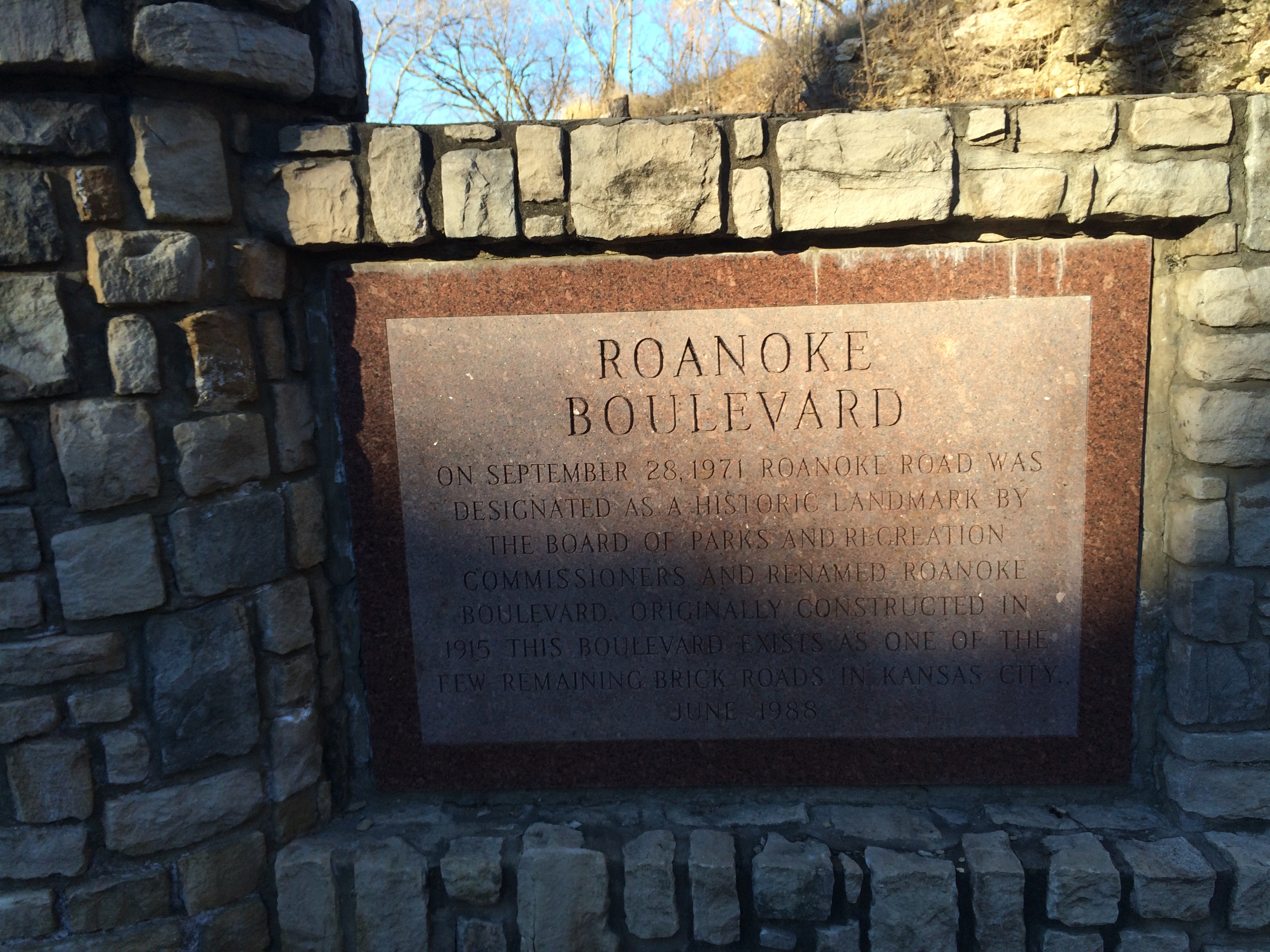
The park associated withthe Parkway is Roanoke park. Built in 1907, it is one of the oldest parks in Kansas City, Roanoke Park has an interesting shape as it tucks itself inbetween the Westport and Midtown areas.
With its beautiful trails, playgrounds, sustainable progress and a Community Center, Roanoke Park stands as a shining example of good park design. From its trails to its wide open spaces, the park offers both passive and active recreation.
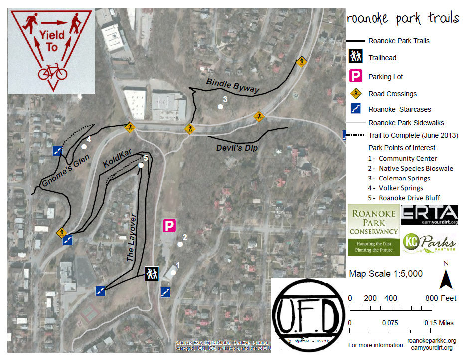
Trail MapHistory of the Boulevard
Sustainable Development
Moving Forward
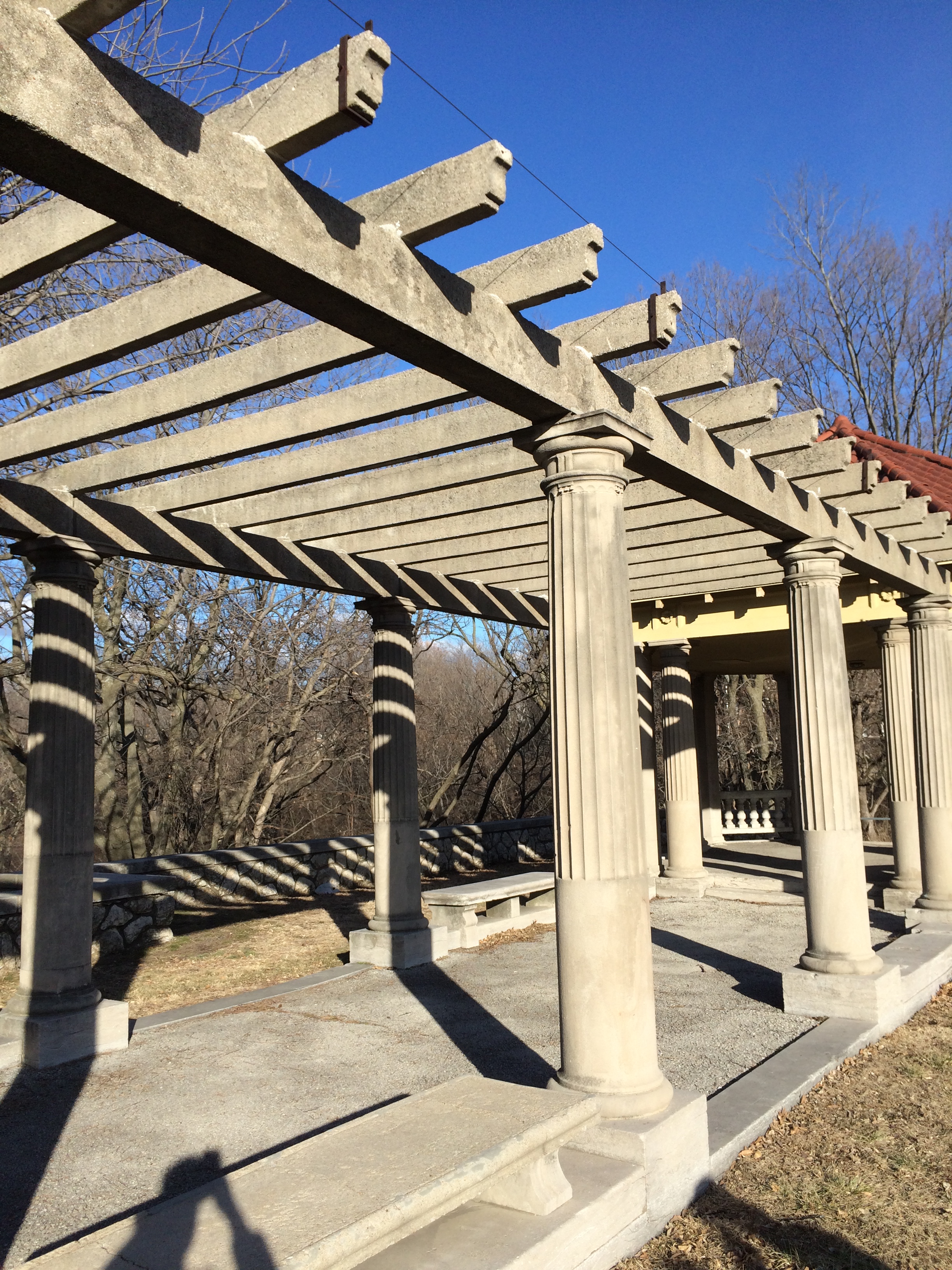
I have lived in this city for 20 years and while I have never been formally taught about Kessler’s vision with the parks and boulevards, I have spent a great deal of time enjoying their beauty. As our class took an excursion to explore some of the eastern parts of the system I realized how little of the streets and park I had actually experienced. Even on a January day, there was a great attractiveness inherent in many of the parks. The Kessler Park near Cliff Drive was quite impressive, it stands as a great example of the City Beautiful movement with its Romanesque columns and its concrete pergola.
“While parks are of inestimable value in making a city inviting to desirable residents and visitors, furnishing pleasant drives to those who can afford these luxuries, adding to the value of real estate, and promoting the general prosperity, these are matters of small consideration when compared to the imperative necessity of supplying the great mass of the people with some means of recreation to relieve the unnatural surroundings in crowded cities.” – Kessler
Kessler Park Pergolas – City Beautiful Movement
The system of parks and boulevards laid a framework for Kansas City. Its good bones provide unique drives and generally pleasant experiences when getting around the city. There are areas of improvement though. How can we explore what styles Kansas City wants to represent in the future? Should we maintain the style of the City Beautiful movement or should we create our own movement as we move further into the 21st century?
 The Sun Link Streetcar system opened in July 25th 2014. It has 23 Stations (17 per direction) with daily ridership around 4,000 (Arizona Daily Star). The length of the line is 3.9 miles, servicing the University of Arizona, Downtown and Mercado. The estimate from the city was 3,600 weekday riders, it exceeded expectations.
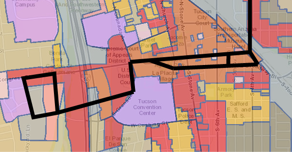


