Historical Figure Grounds made by Bradley Hocevar. Bottom Image from SHSOM
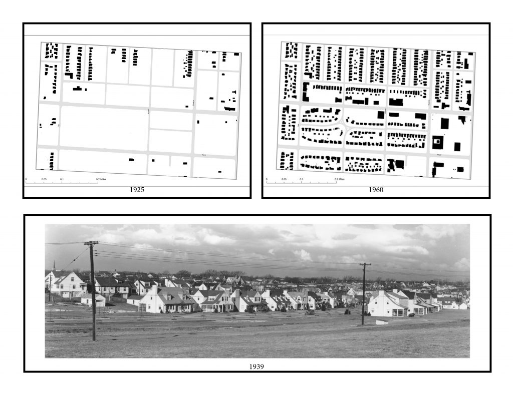
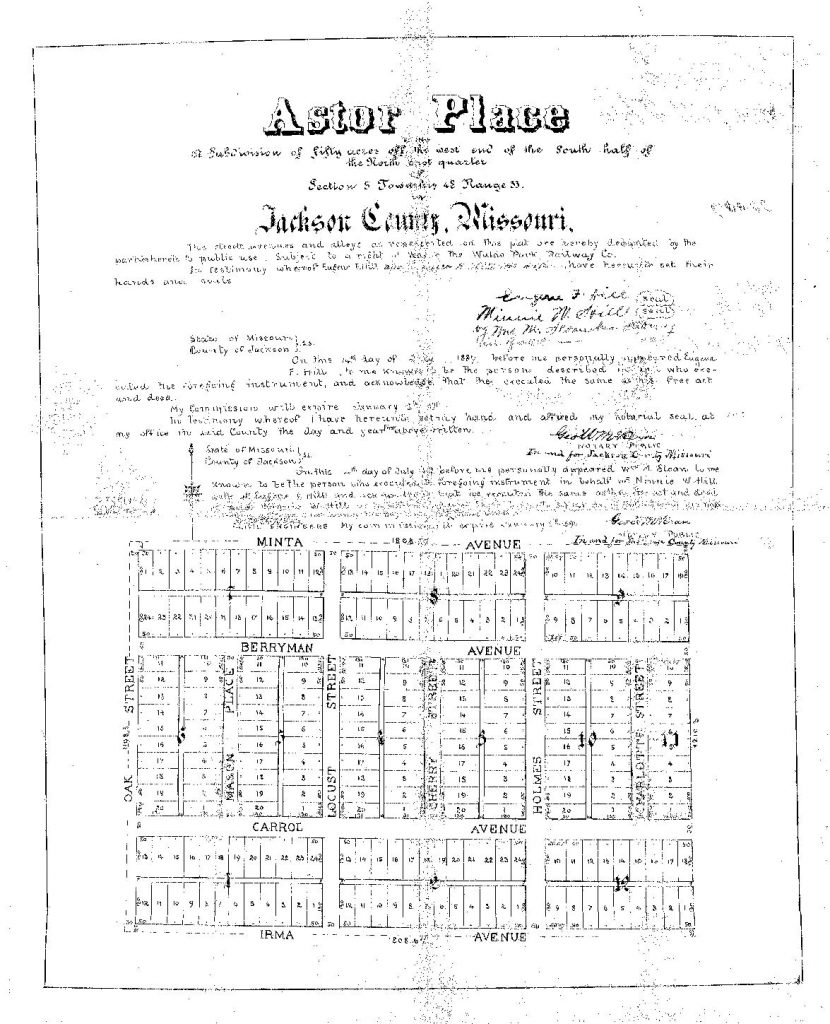
From 1925 to 1960 drastic changes swept over the 63rd Street corridor between Oak St. and Rockhill Rd. As residence were eager to escape the congested and over crowded urban core, developers and home-builders saw ample opportunity in vacant land along the emerging commercial hub. Astor Place, which was established in 1887 by Eugene Hill, and later incorporated into the 49/63 Neighborhood Coalition in 1996, was one of the first neighborhoods to take advantage of the city’s new streetcar system.
Source: Social Explorer
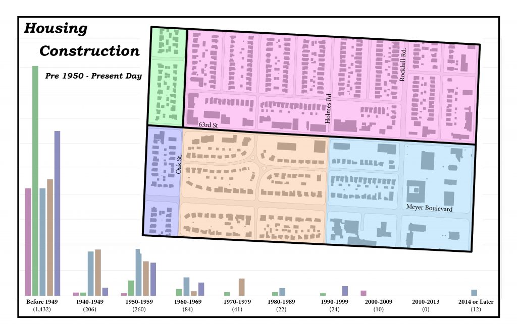
While nearly all construction took place before 1950 in the Astor Place neighborhood, J.C. Nichols chose to take a much more patient and inclusive approach to the development of his Oak Meyer Garden neighborhood. This land was purchased in May of 1927, before the construction of Cherry St. or 63rd Terrace. It reaches north south from 63rd St. to 69th St. and east west to Oak St. and Holmes Rd., strategically placed near many of his own commercial investments.
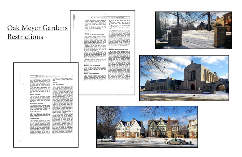
Picture by Bradley Hocevar. Historical Restrictions From Oak Meyer Grandens Homeowners Association.
To this very day, the neighborhood has seen little change due in part to the seemingly endless restrictions placed upon homeowners. Stringent guidelines bar owners from veering astray from Nichols original vision for the neighborhood which emphasized beauty and conformity. This of course has had its drawbacks which continue to linger over and divide our city today.
Although there has been relatively minor spatial changes within the area between Oak and Rockhill Rd. since 1990, a number of new businesses have emerged in recent year along 63rd St. Heirloom Bakery, Canihaveabite, and BKS Artisan Ales have flourished among a new, younger demographic in the area. Mixed use buildings have replaced older, deteriorating ones allowing residence to both work and relax in a unique part of our city without changing much of its historical charm.
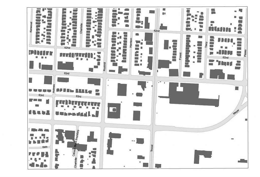
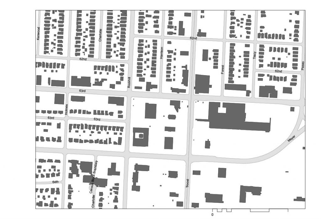
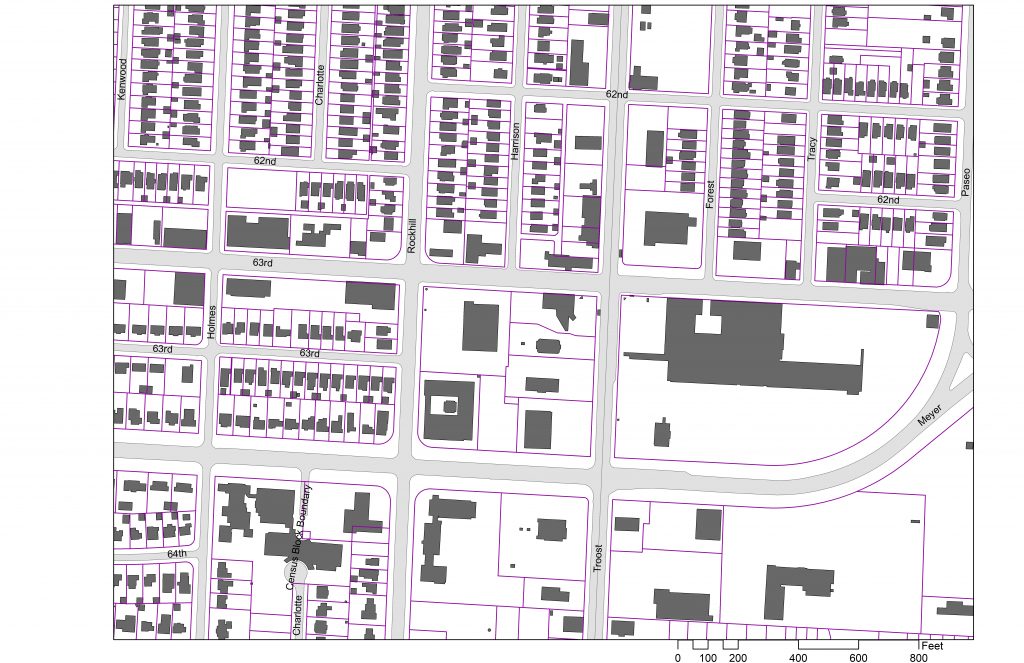
Figure 1. Figure-ground animation showing development history around 63rd & Troost Ave. Diagram by Tom Meyer
In 1909, Kansas City, Missouri annexed the land between Brush Creek and 77th street, officially bringing our study area into the fold of the rapidly expanding metropolis (City Planning & Development Dept). The intersection of 63rd and Troost Avenue was perfectly positioned in the center of this expansion to become a transportation and commercial hub for the surrounding residential area.
Troost Avenue had been graded to 63rd Street by 1883 (KC Star, 05.14.1884). A line of the interurban railway system was extended past the intersection in 1904 (KC Star, 04.15.1904). The grading of Troost Ave and the extension of the rail system led to the subdivision of the large land holdings in the area.
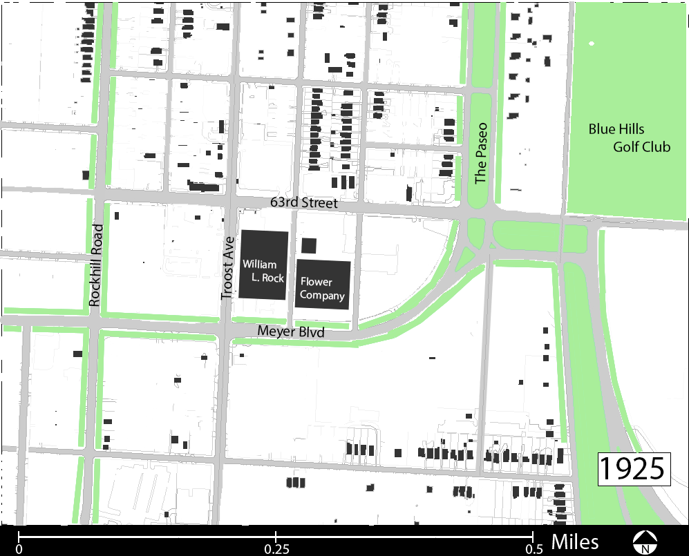
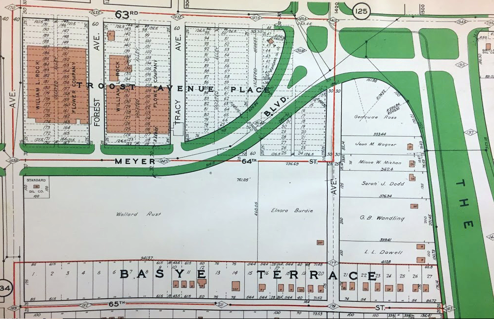
In 1888, a plat for Troost Avenue Place, on the future site of the landing, was one of the first to be filed with Jackson County (Jackson County). A single owner, the William L. Rock Flower Company, snapped up most of these lots and built two large greenhouses there (Figure 2). These greenhouses would stand until the 1940’s and remain in continuous operation by the Rock Flower Company (KC Star, 01.10.1947).
Figure 2. 63rd St. to 65th St. between Troost Ave and The Paseo showing the Rock Flower Company; large, individual land holdings; and limited development of single family homes on 65th. Source: 1925 Tuttle & Ayers Atlas of Kansas City, MO
With annexation in 1909 the boulevard system was extended into the area. The Paseo, the main north-south corridor of the system, was given an intricate intersection with the newly planned east-west corridor of Meyer Boulevard.
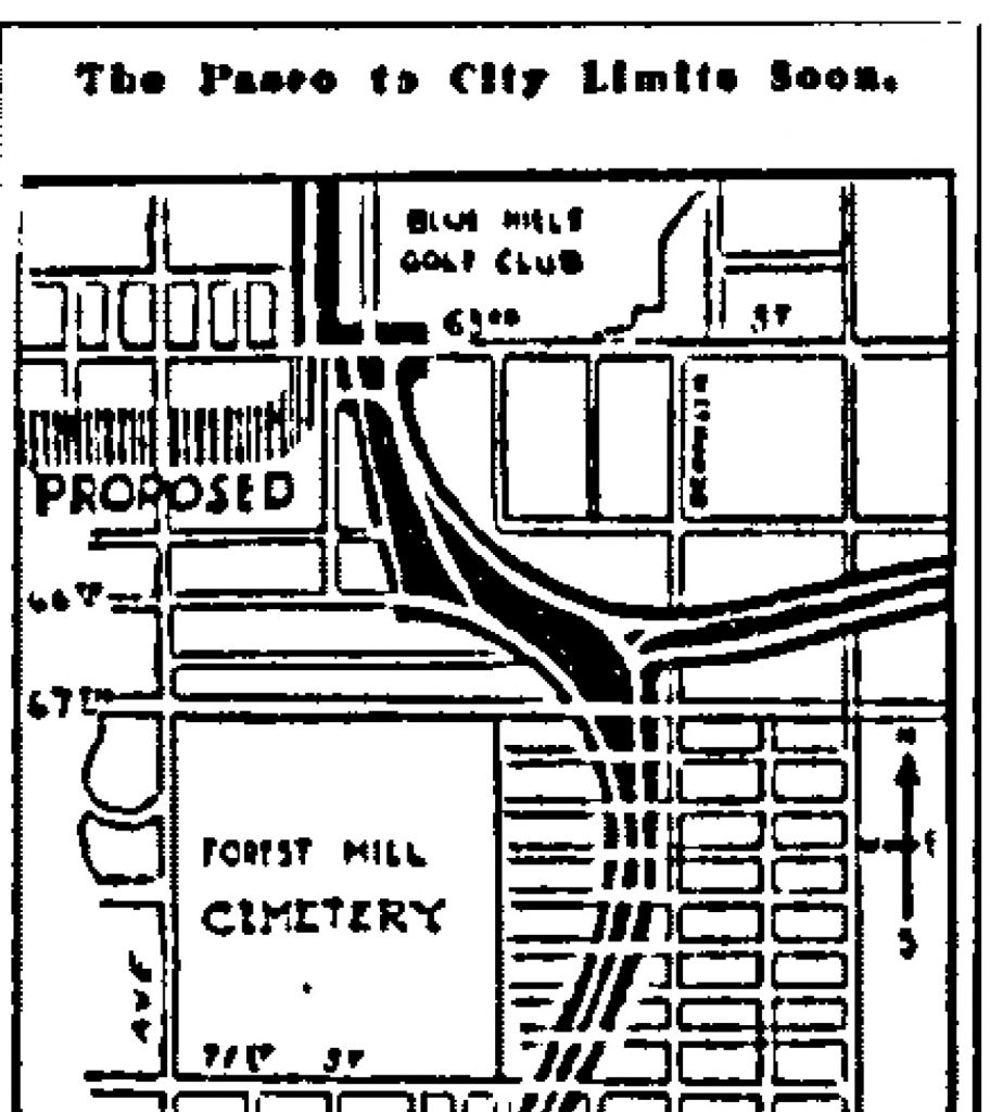
The path of this new boulevard was graded in 1915 (KC Star, 10.27.1915) but the outbreak of the First World War, and subsequent material rationing, prevented it’s paving until the conclusion of the war in 1918 (KC Star, 10.27.18)
Figure 3. Map from the Kansas City Star showing proposed path of Meyer Blvd and Extension of The Paseo. (KC Star 1919)
Some tracts of land along the new boulevard were not subdivided (KC Parcel Viewer). The area immediately south of Meyer Blvd. at it’s intersection with The Paseo was likely too steep for the development of small lots. Today, this area forms the grounds of the Convent of Christ the King, built in 1948, and Hogan Preparatory Academy, built in 1940. Only one lot of this area was sold from the whole, that being at the corner of Meyer Blvd and Troost Ave, which was sold to a gas station interest in 1921 (KC Star, 05.27.1921).
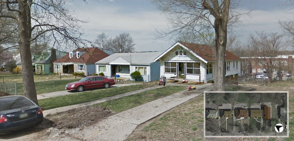
65th Street, between Troost Avenue and The Paseo, was subdivided as Basye Terrace in 1916 (Jackson County), though housing construction didn’t commence until the mid-1920’s (KC Parcel Viewer). Even then, many of the lots remained unsold for another 30 years (KC Parcel Viewer). This gap of construction is evident in the styles of home on the street. 1920’s bungalows can be seen built right alongside mid-century Cape Cod homes (Figure 4).
Figure 4. Single family homes on the north side of 65th street from two different eras. Source Google Maps, edits by Tom Meyer
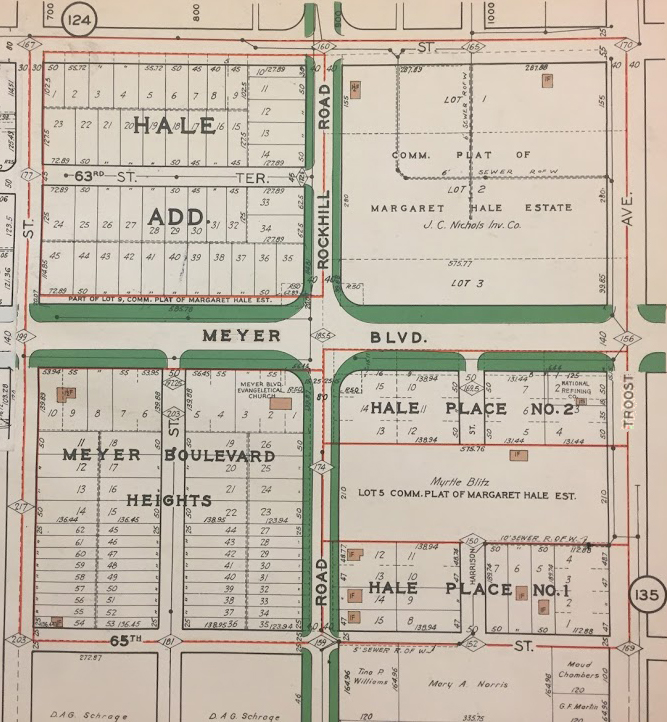
Once Meyer Boulevard was paved, platting and development along its corridor began in earnest. The plats for the Meyer Boulevard Heights and Hale Addition subdivisions were filed within five years of the completed roadwork (Jackson County).
Figure 5. 1925 Atlas showing lots, building footprints, and subdivision names on either side of Rockhill Rd. Source: 1925 Tuttle & Ayers Atlas of Kansas City, MO
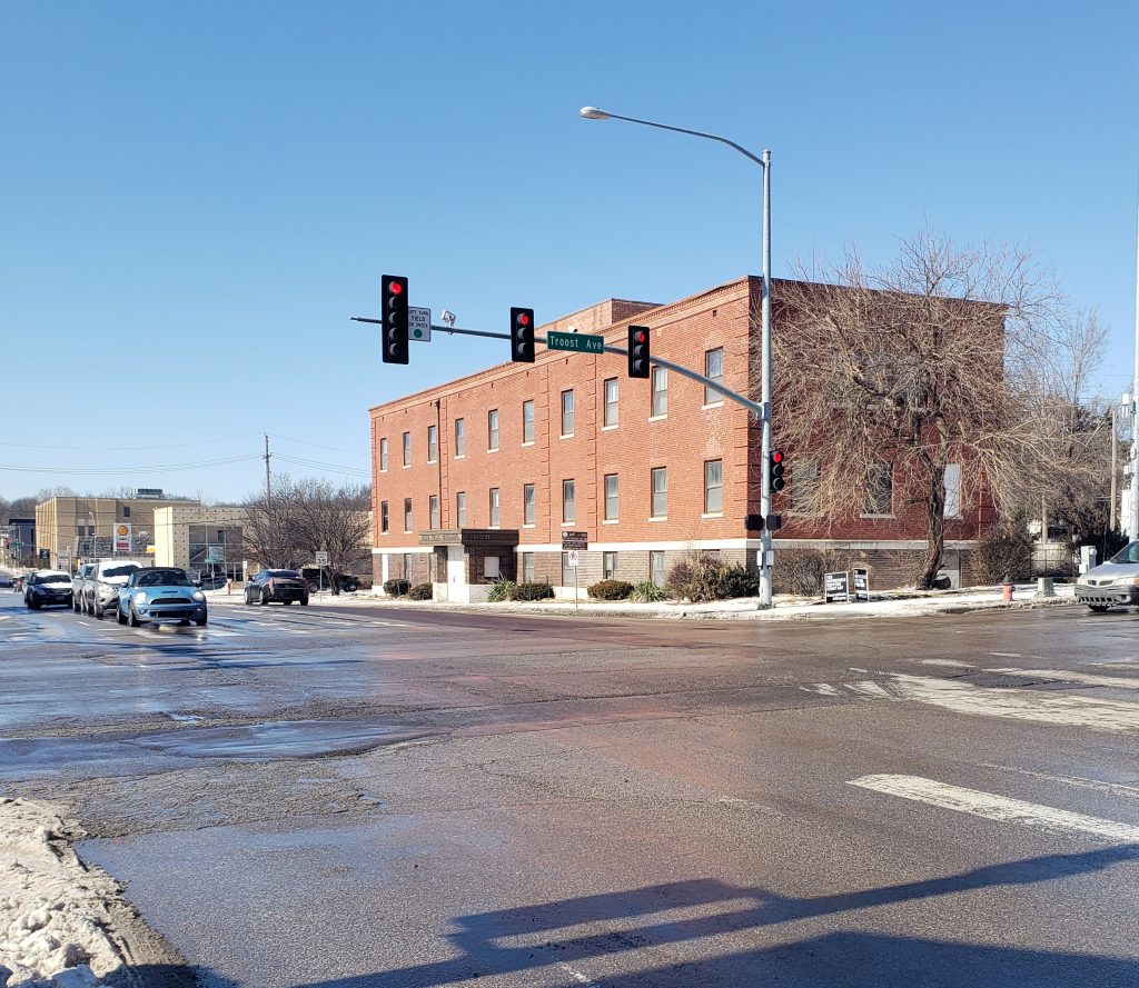
The commercial block between 63rd St. & Meyer Blvd. and Rockhill Rd. & Troost Ave. was developed by the J.C. Nichols Company (Figure 5). Many of the buildings on this block date to the mid-century as evidenced by the architectural styles of the Rockhill Plaza building and the A-Z Theatrical Supply Company. The former church and current home of the Banneker charter school is of a similar vintage. An exception to this mid-century style is the U.S. Bank building at 63rd St. and Troost Ave. which dates to the 1920’s (KC Parcel Viewer).
The J.C. Nichols company purchased the former grounds of the Rock Flower Company in 1946 and began demolition of the greenhouses and supporting structures in early 1947 (KC Star, 01.10.47). The site would remain empty for a decade until the Nichols company began development of The Landing Shopping Center (06.16.1957), which would open in 1961 (KC Star, 02.27.1961).
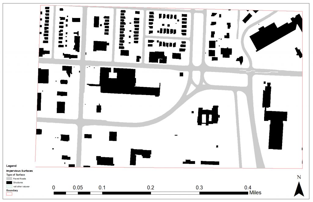
Today, the ample parking along with the many pad-site buildings fronting Troost Avenue show the auto-centric character of the area (Figure 1).
References
Historic Aerials. (n.d.). Retrieved February 4 , 2019 from https://www.historicaerials.com/viewer
Jackson County. Retrieved 2019, from http:// records.jacksongov.org
Kansas City Star. May 14, 1884: p8. Newsbank. Web. 4 Feb. 2019
Kansas City Star. April 15, 1904: p6. Newsbank. Web. 5 Feb. 2019
Kansas City Star. January 10, 1947: p3. Newsbank. Web. 5 Feb. 2019
Kansas City Star. October 27, 1915: p7. Newsbank. Web. 5 Feb. 2019
Kansas City Star. October 27, 1918: p8. Newsbank. Web. 8 Feb. 2019
Kansas City Star. May 27, 1921: p2. Newsbank. Web. 8 Feb. 2019
Kansas City Star. June 16, 1957: p8. Newsbank. Web. 8 Feb. 2019
Kansas City Star. February 2, 1957. MVSC. Microfilm. Shopping Centers: The Landing
Kansas City Star. March 1, 1961. MVSC. Microfilm. Shopping Centers: The Landing
A look into the past development of the corridor near ‘The Landing’
First development
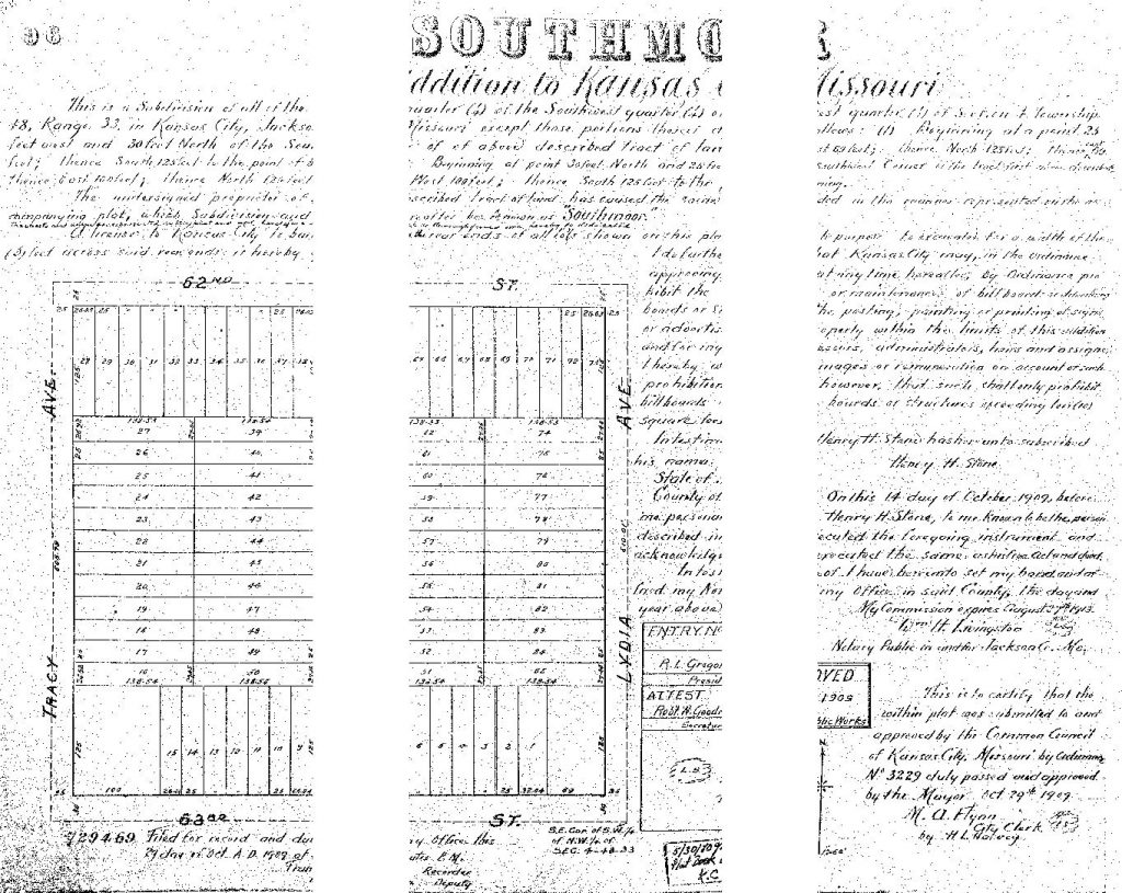
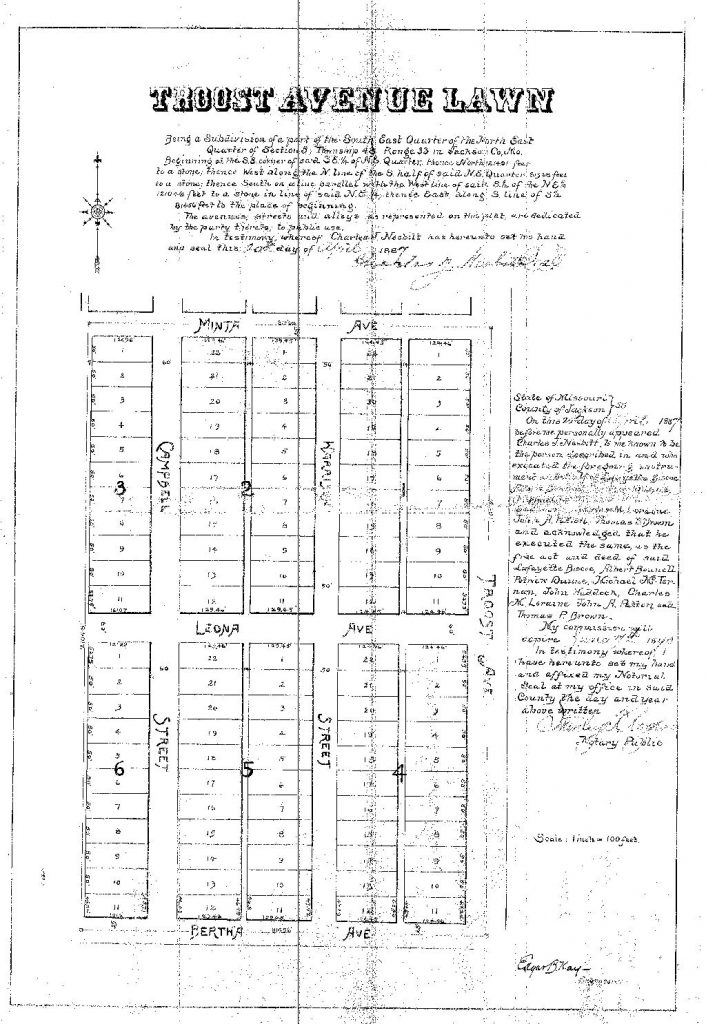
Development of the area first arrives in the lake 1800’s as the area was beginning to be platted off with the ‘Troost Ave. Lawn’ development. On April 20th, 1887 Charles Nesbit was approved by the city of Kansas City, Missouri to begin developing the “part of the south east quarter of the north east quarter of section 5 township 48, range 33 in Jackson Co. Mo” . Many others followed soon after with ‘Astor Place’ being the next plat on July 14th, 1887, with Holmes splitting it right in the middle. The ‘Southmoor’ subdivision that hugs the east side of Tracy Ave. was platted in October of 1909 and the final plat, ‘Dyer Place’ that is just west of Tracy, opposite of Southmoor was platted in march of 1910.
Gallery 1. 63rd Street Corridor Plats -Courtesy : JacksonCounty.gov public records
Neighborhood Shaping
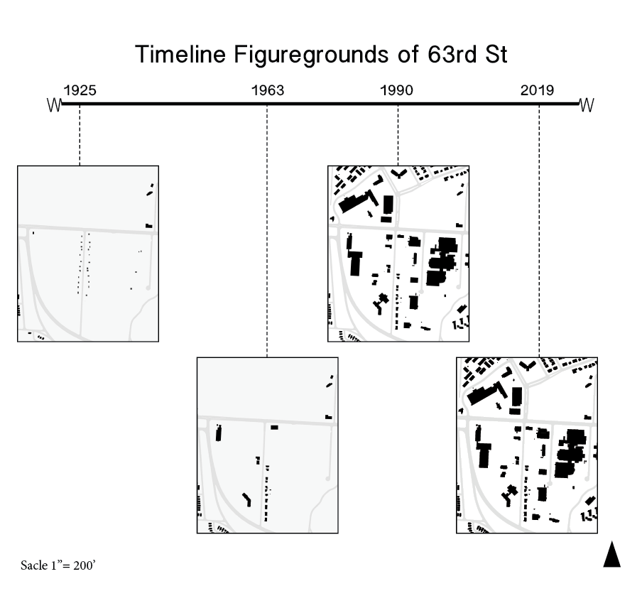
The neighborhood structure grew exponentially within the early 1920’s and holding steady with the mall being an addition in the early 60’s. The decrease in the neighborhood structure really is showing in more current times as some of the neighborhood mesh is being unwoven. The streetcar suburb’s network was created to be moderately dense for easier walk ability with the streetcar use but since the automobile came to rule the area, this has made the high density less desirable.
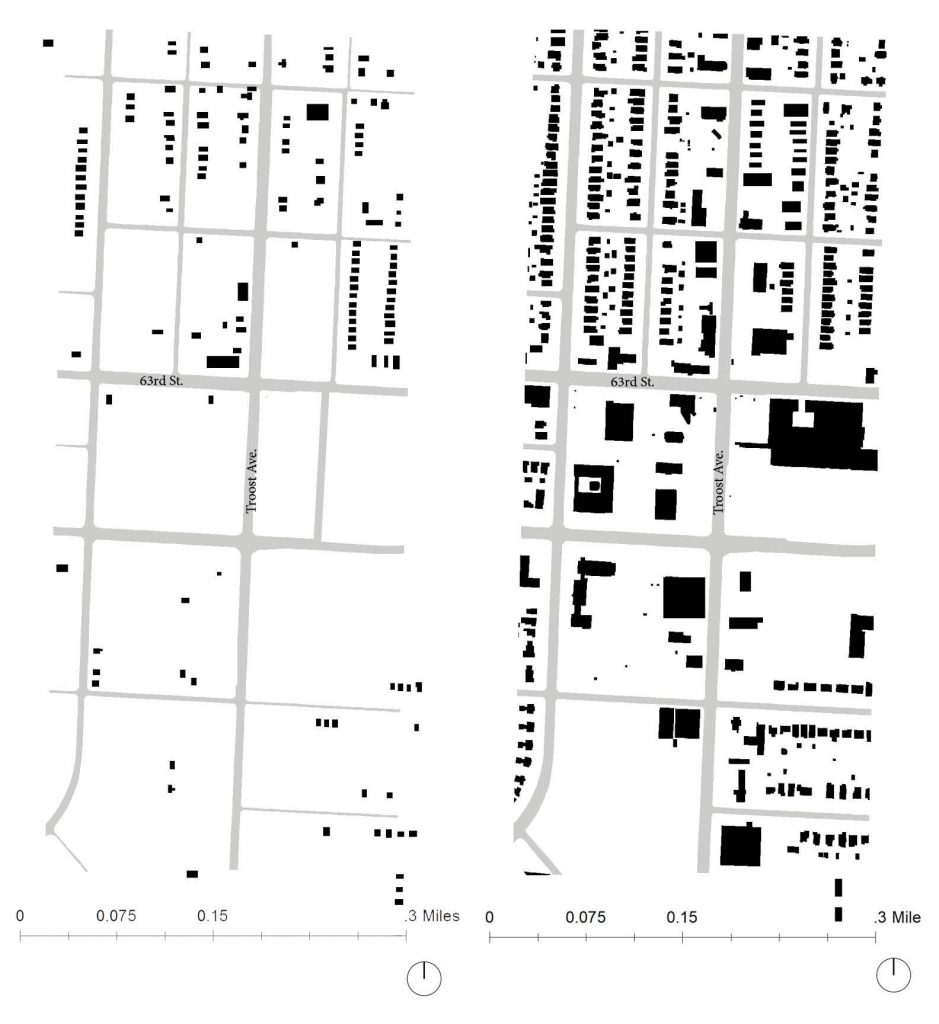
Fig. 1- 1925 Fig. 2- 1965Fig. 3 – 1991Fig. 4- 2019 All maps created by: Logan Sours
Analytical Thoughts
The neighborhoods surrounding the Landing mall reflect what is going on inside. through the years it is apparent that it has had a booming time between the opening of the mall in 1961 and the early 90’s while it has rapidly lost business in the present. There is still a strong neighborhood network that with a little more connectivity to the streets and surrounding area, could improve the quality of the forgotten mall.
The area around The Landing Mall began as a suburban escape from the urban core. The southern expansion of Kansas City can be noted by curvy streets and larger parking lots. The surrounding neighborhoods were built around the park and boulevards system in Kansas City, making it a desirable place to live when it began. As suspected, the area surrounding the Landing was not very populated in the 1920s but in the 19603, around when the Landing was built, the area became pretty dense. Since then it has seen some demolition of buildings and the ground is less packed.
1963 Figure Ground Map Surrounding The Landing (1″=200′). Made by Adair Bright2018 Figure Ground Map Surrounding The Landing (1″=200′). Made by Adair Bright
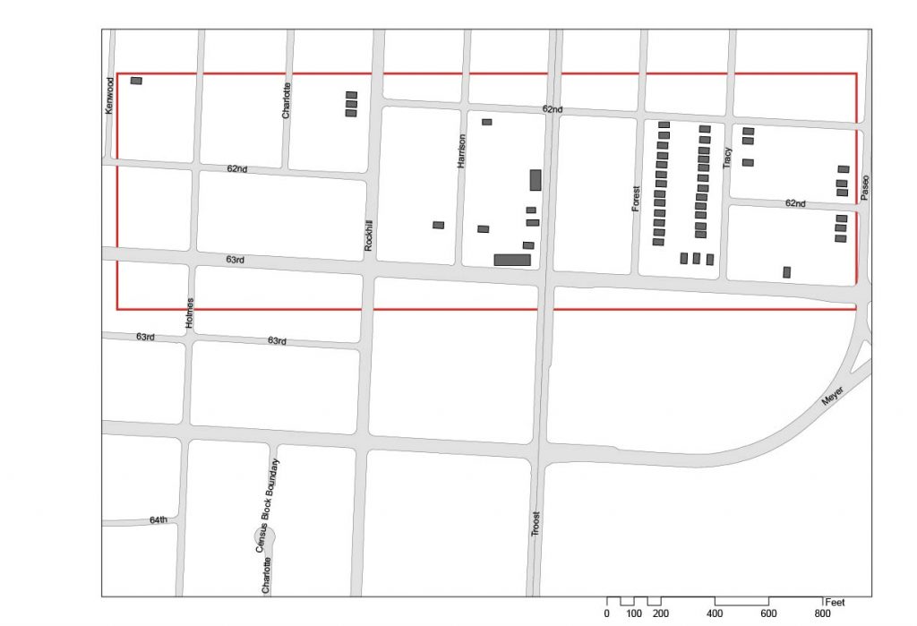
Describing the seemingly complex intersection of 63rd Street, Meyer Boulevard and The Paseo, famed Architect and Urban Designer, Ted Seligson, refers to it as “the knuckle” of Kansas City’s boulevard system. Viewing the intersection from an aerial view, Seligson’s analogy becomes clear. The way Meyer Boulevard merges into The Paseo, then briefly runs parallel with 63rd Street, before finally turning back down into itself, looks like a person’s finger joints. The knuckle, which lies just East of The Landing (which was discussed in my last blog), is a node that various different land uses gather around. Not only is this the case for present day (currently a mix of residential, commercial and institutional uses surround the knuckle) but it has been the case for the past 100 or so years. This post will look at how the area immediately surround the knuckle has developed over time.
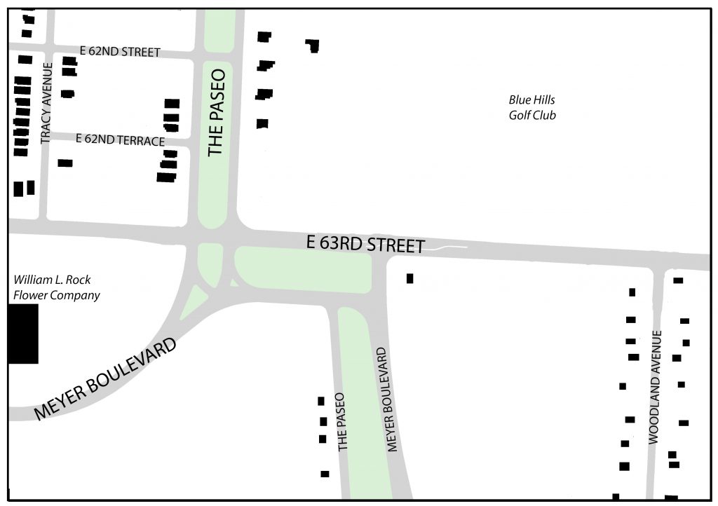
1925 Figure Ground Map – 63rd Street between Tracy and Woodland Avenues. Source: Jared Islas, 2019.
The earliest developments in the area were mostly single-family residences. These homes mostly originated along Tracy and Woodland Avenues, with some additional homes appearing on either side of The Paseo. Many of the homes on Tracy and The Paseo will remain intact through to present day, but the same can not be said for those on Woodland.
According to the 1925 Atlas of Kansas City, the present-day Landing site was formerly home to two large greenhouses known as “William L. Rock Flower Company.” These greenhouses would also not last long, as they would be sold to JC Nichols in the mid to late 1940’s who would go on to develop The Landing Mall (Kansas City Star, 1947).
Also, just Northeast of the knuckle, sat the Blue Hills Golf Club. This would remain an important part of the neighborhood up the site was redeveloped for a suburban-esque retail shopping center and neighborhood.
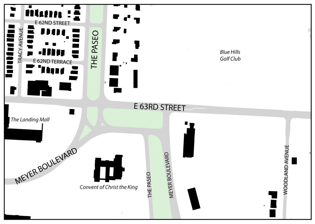
1963 Figure Ground Map – 63rd Street between Tracy and Woodland Avenues. Source: Jared Islas, 2019.
By 1963, more single-family residences had filled up the area Northwest of the knuckle and almost all of the houses that had been fronting Woodland Avenue had disappeared. Also, Convent of Christ the King, and some other institutional/office buildings sprung up South of 63rd Street. And The Landing mall was constructed on the former site of the two large greenhouses.
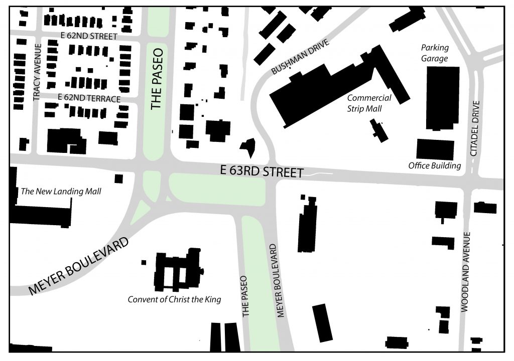
1991 Figure Ground Map – 63rd Street between Tracy and Woodland Avenues. Source: Jared Islas, 2019.
By the early 1990’s, the Blue Hills Golf Club was gone and replaced by the suburban-esque strip mall, a six-story office building and a three-story parking garage. Commercial pad sites began developing around the knuckle and other intersections along 63rd Street.
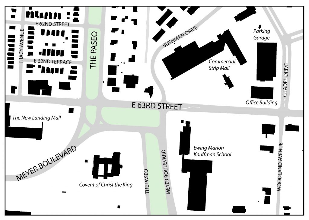
2019 Figure Ground Map – 63rd Street between Tracy and Woodland Avenues. Source: Jared Islas, 2019.
As of today, the area around the knuckle has not changed much since the early 90’s. The only major difference is the large additions to building at the Southeast corner of 63rd and Meyer. These buildings ultimately became the campus for the Ewing Marion Kauffman School, which is a public charter school.
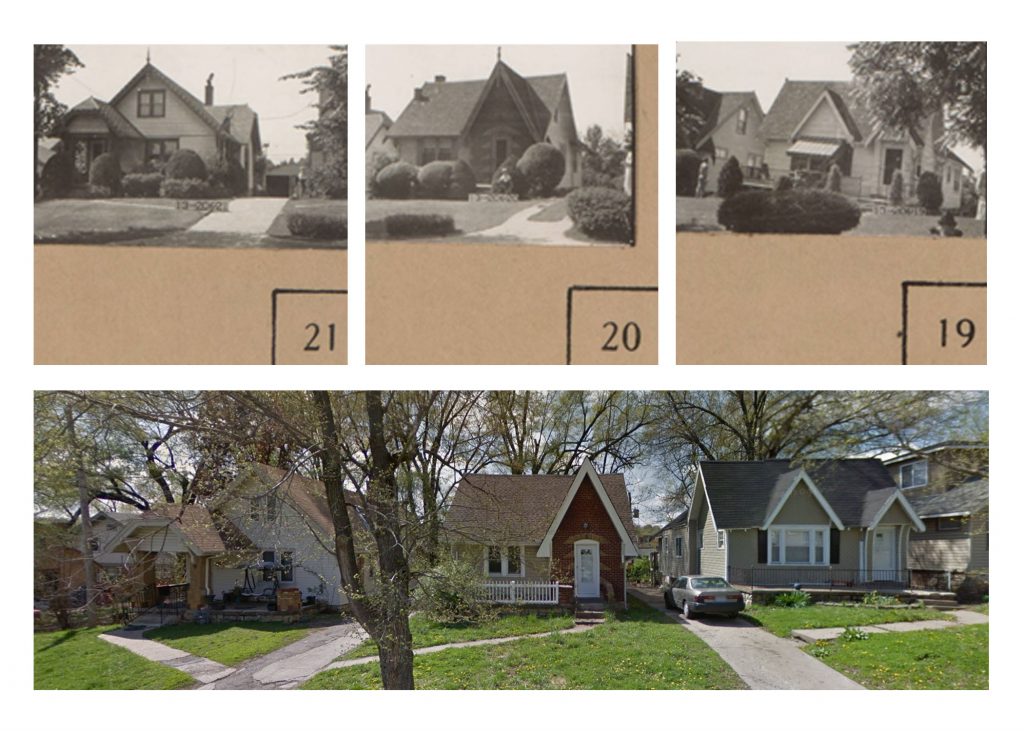
While the structures and their uses surrounding the knuckle have changed in the last 100 years, there are some things that have remained the same. The first being some of the older, now historic, single-family homes on 62nd Terrace. The picture below shows these homes first in 1940, as part of the 1940 Tax Assessment photos, and then again in 2015 through Google Maps Street View.
Comparison of single family homes on 62nd Terrace Source: 1940 Tax Assessor photos and 2015 Google Street View
These structures have remained relatively untouched during the almost 80 year gap that these photos were taken. The only things that have changed are expected renovations in older homes like these – materiality and landscaping.
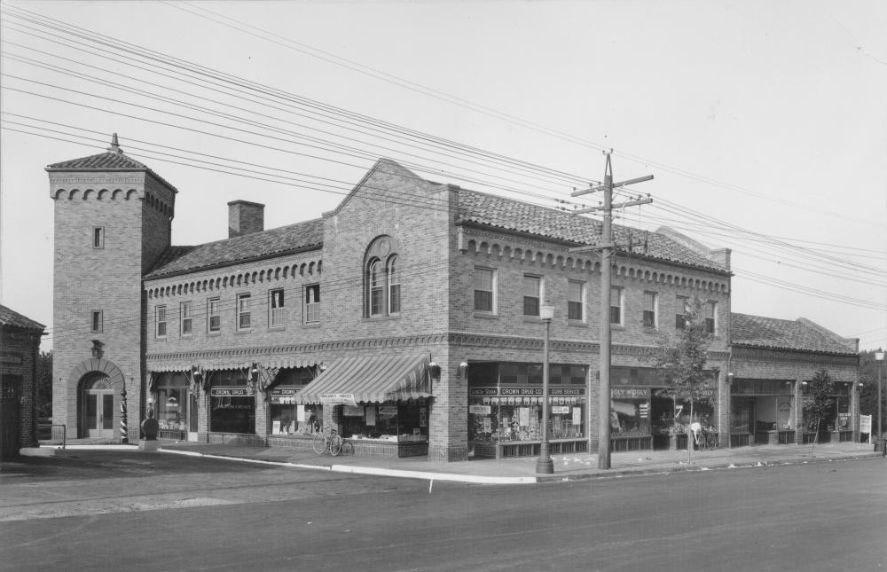
The next set of photos, comes to the same conclusion. This commercial building, located halfway in between Tracy Avenue and The Paseo on the North side of 63rd Street has also remained relatively unchanged.
Comparison of a commercial building on 63rd Street. Source: 1940 Tax Assessor photos and 2018 Google Street View.
These historic photos show that while there have been some structures that have been around for the better part of the last 80 years, nothing compares to the longevity of the knuckle.
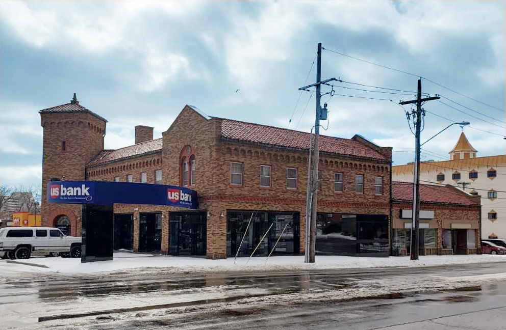
Only less than 100 years ago the area between 62nd street – 66th street and Rockhill Road – Troost Avenue was just beginning its development. A new shopping center on the southwest corner of 63rd st and Troost Ave. was built in the late 20s as neighborhoods began to move away from the city’s core. This shopping center offered a drugstore, barber shop, and restaurants, but has since been replaced with a US Bank and empty units. It is great to see this building is still standing strong and features its original structure, but it does not feel as lively as it looked in the late 20s. Figure 1 shows the 63rd and Troost Shopping Center in 1927 compared to today in 2019 (Figure 2).
Another building that has stuck around is the Highland Telephone Exchange Building, now called the Blue Hills Building. Located on the northwest corner of 63rd st and Troost Ave. and was placed on the National Register of Historical Places in 2005. Telephone exchange buildings were build in the “heart of the area they would serve” and were necessary for connecting calls during this period. Once an important structure now sits vacant with boarded up doors and broken glass window.
Since 1925, this area has greatly advanced. Blocks that were almost completely empty have been replaced with homes and retail shops. Largest changes in the area can be seen between the 1920s and the 1960s. Residential neighborhoods continue to stay north of this area and commercial structures remain more south. Looking at figure grounds from 1990 and 2019 there is little modifications. Few structures have disappeared leaving behind open land. This open land is opportunity for development and growth.
Figure 5. Figure ground maps of 1925 & 1963 created by Cristina Aurich 02/2019 Figure 6. Figure ground maps of 1990 & 2019 created by Cristina Aurich 02/2019
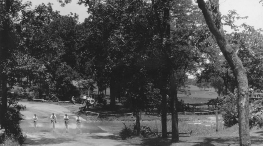
1922. A view of the ford just below 63rd Street, looking south. The rustic bridge leads down to the road from the club house, known then as the “The Lodge” and located about where the home of Dr. and Mrs. Thomas G. Orr now stands.
The Landing on 63rd and Troost was a marvel of its time. It was a product of desire and want in a time of major sprawl. This was the heyday of horse racing, high-class sports, and a time of prosperity. People could afford to go out and spend money, women, in general, did not have jobs and could spend time during the week visiting shops and enjoying leisurely activities. But how did it affect the surrounding area and how has the late 20th and early 21st-century lifestyle changed the way this area has changed?
After World War 2 ended, a slew of men came home and a proliferation of whole new generation proceeded. The Baby Boomers. An astronomical number of homes needed to be built and they all had a certain western requirement; windy roads and large plots of land.
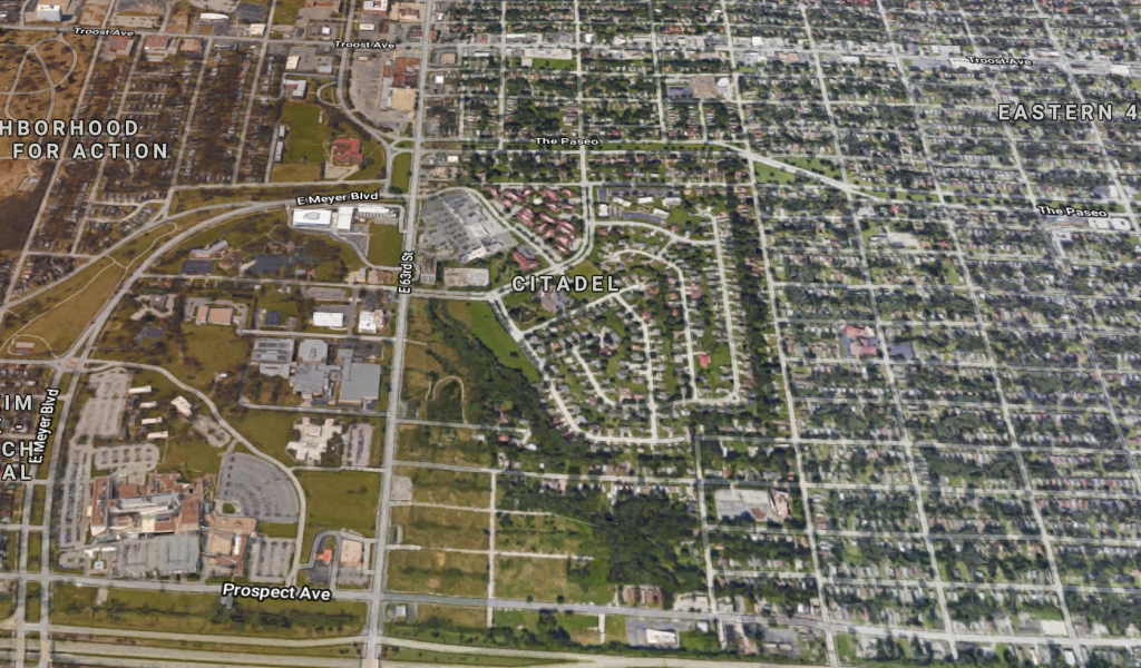
Google Image of 63rd around the Citadel Neighborhood facing West
Before Citadel was created for the purpose of satisfying the housing shortage, it was a golf course (not unlike the first image, which was on 63rd a few neighborhoods down). You can tell exactly where it was because of the stark contrast of street types, from a ridged grid to a windy post-WW2 sprawl type road.
The oldest building in the small context of between Brooklyn and Meyer is one dating from the 50’s, that being the Nazarene Theology School to the south. From there, the majority of the development was done in the 80’s, around 10 years after the completion of the Landing for context.
Figure ground comparison between Brooklyn and Meyer
There was an extremely large bolstering of development, as we can see from the figure grounds above, from 1963 to 1990. Then after that, there is a stall in development that is consistent with census household data. There was not much development from before the ’80s and therefore after.
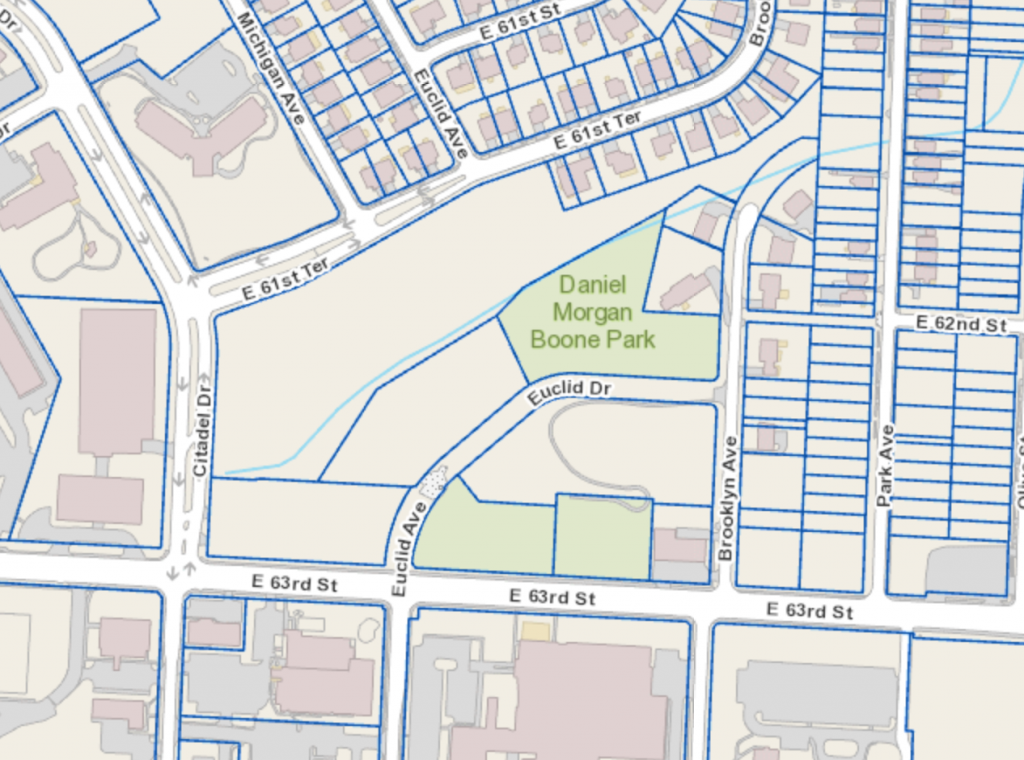
Parcel view of section of land about 63rd street via Parcelviewer.com
The major travesty is that what was once a large expanse of open land, granted it was short grass and few trees, has been broken up and now the only remanence of the once huge plot of nature is now a small section (shown in green in the above picture). Which reminds me of one of my favorite quotes from James Kunstler, “In the context of contemporary culture…”green space” or “open space” essentially means build nothing. It is a rhetorical device for putting city land in cold storage in the only acceptable form, that is, covered by grass and shrubs, aka nature.”