Brougham Trace

For this semester’s final project, we were responsible for choosing a key location along the Parks and Boulevards System, within the 1940 boundaries of Kansas City. My site is located on the southern end of Gillham Park, from Brush Creek Boulevard to Emanuel Cleaver II Boulevard, between Troost Avenue and Campbell Street. It is an important artery for residesnts in the surrounding areas, including the Hyde Park, Southmoreland, and Rockhill neighborhoods, as well as the Midtown Wesport area. Currently, however, the park itself lacks important North-South connectivity, causing a major disconnect within the Parks and Boulevards System.

Aeiral_Pre
Site Context

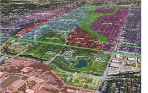
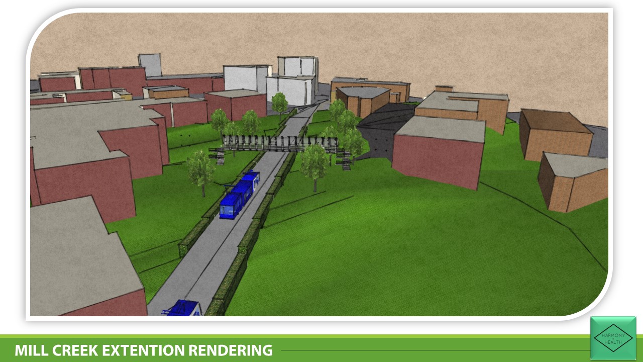
To connect this area completely to the rest of Kansas City’s system, Gillham park has been extended to connect to Emanuel Cleaver II Boulevard, ultimately linking Emanuel Cleaver, Brush Creek Boulevard and Armour Boulevard together.

Aeiral_Post
Gillham Park Extension

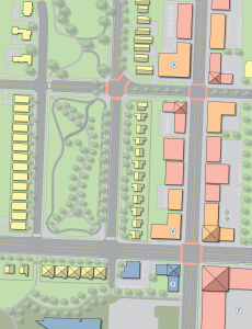
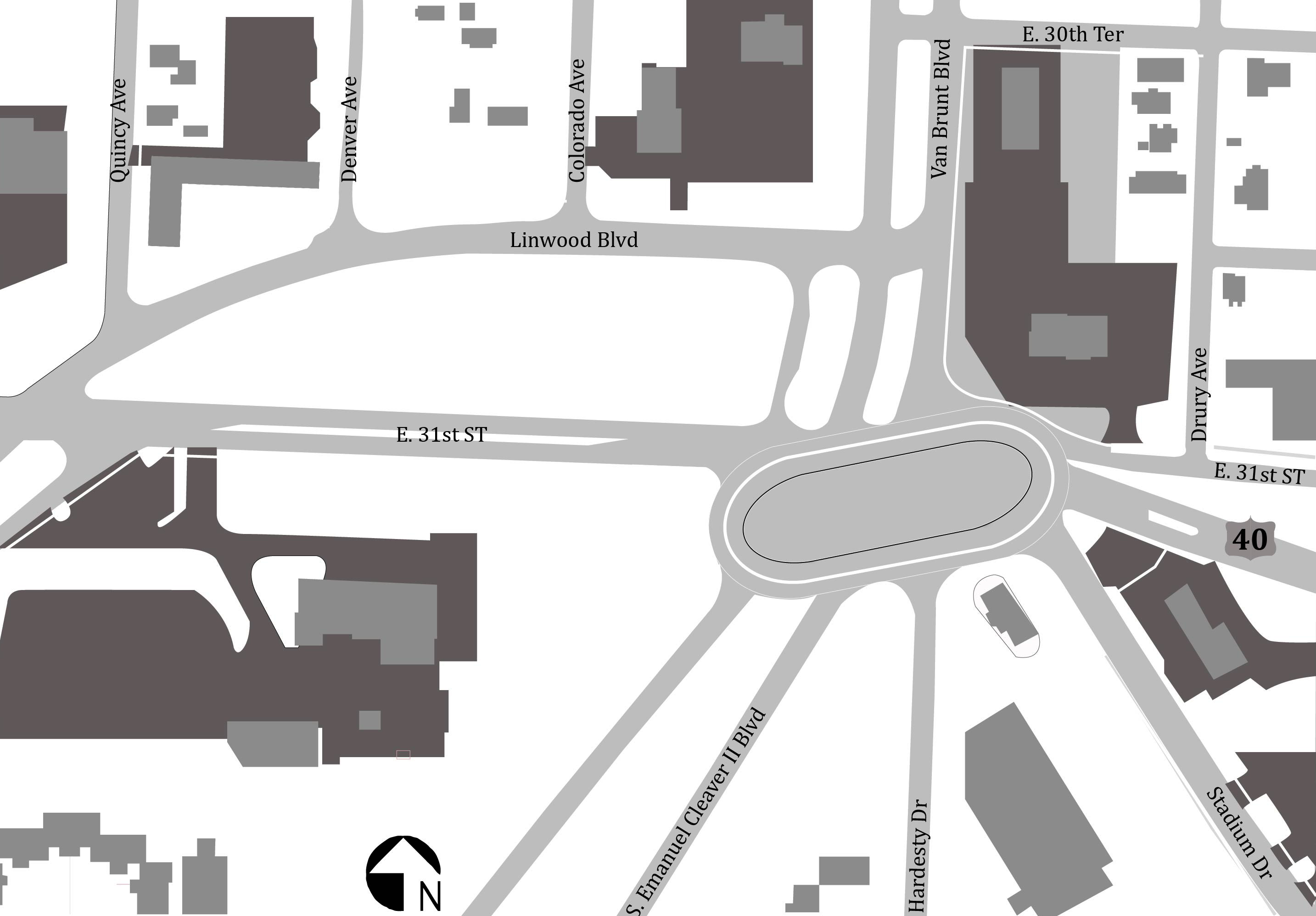
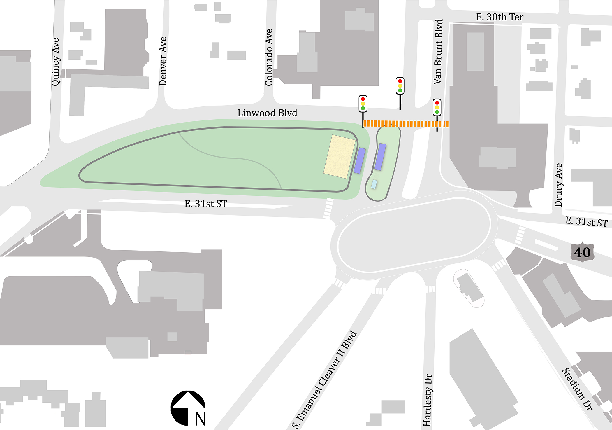
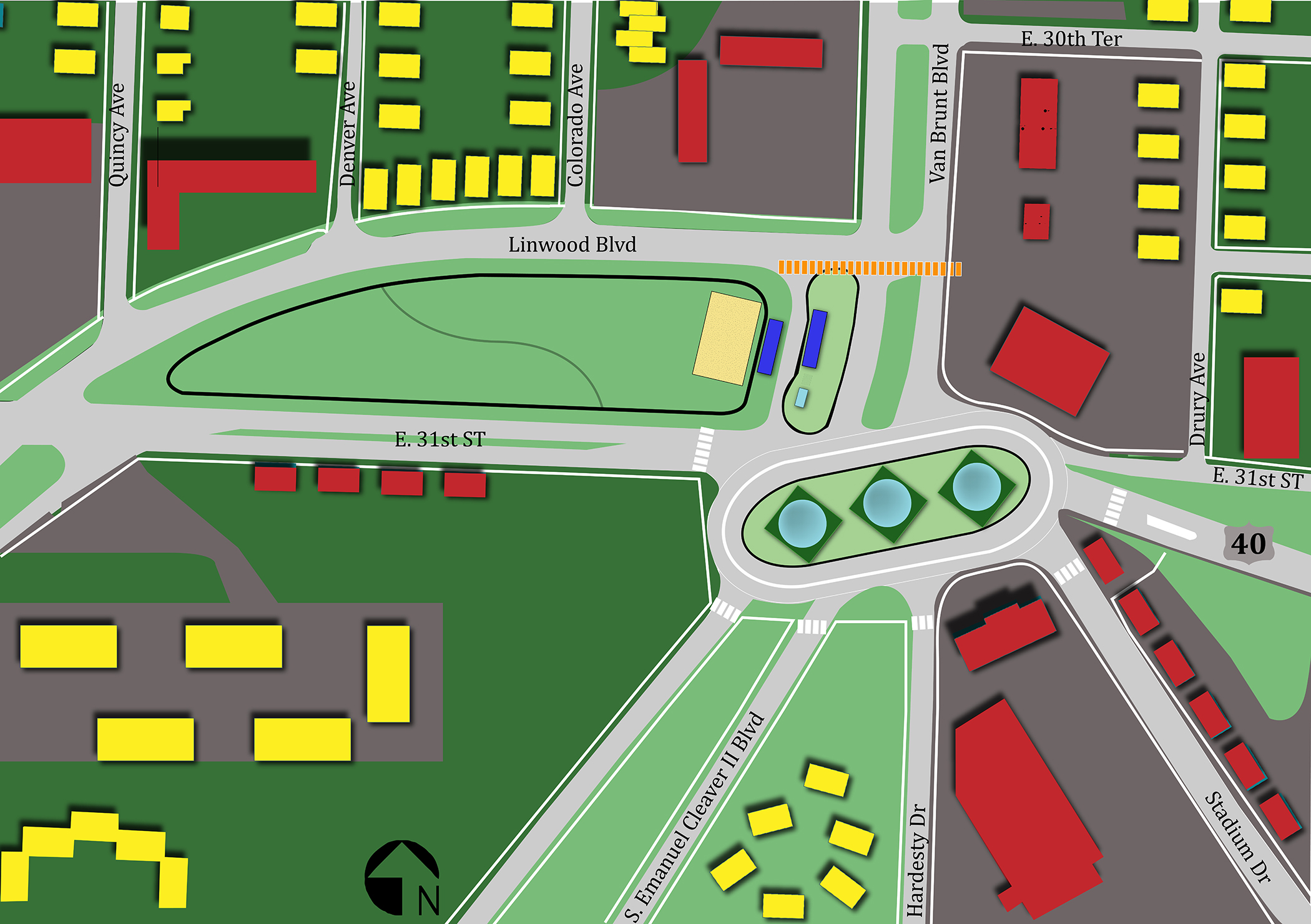
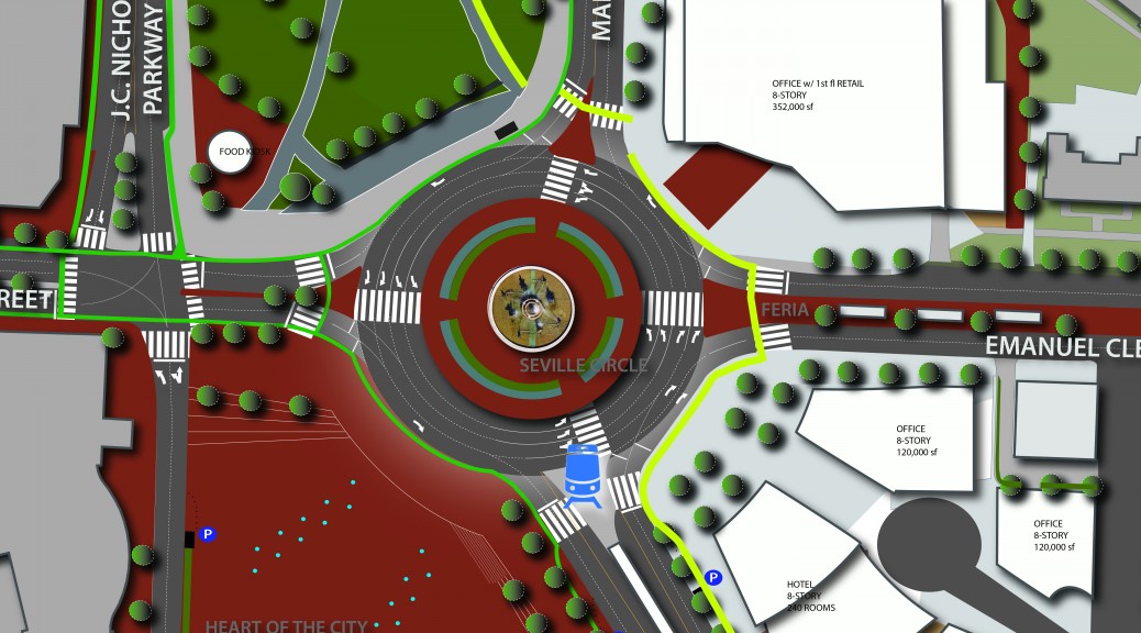
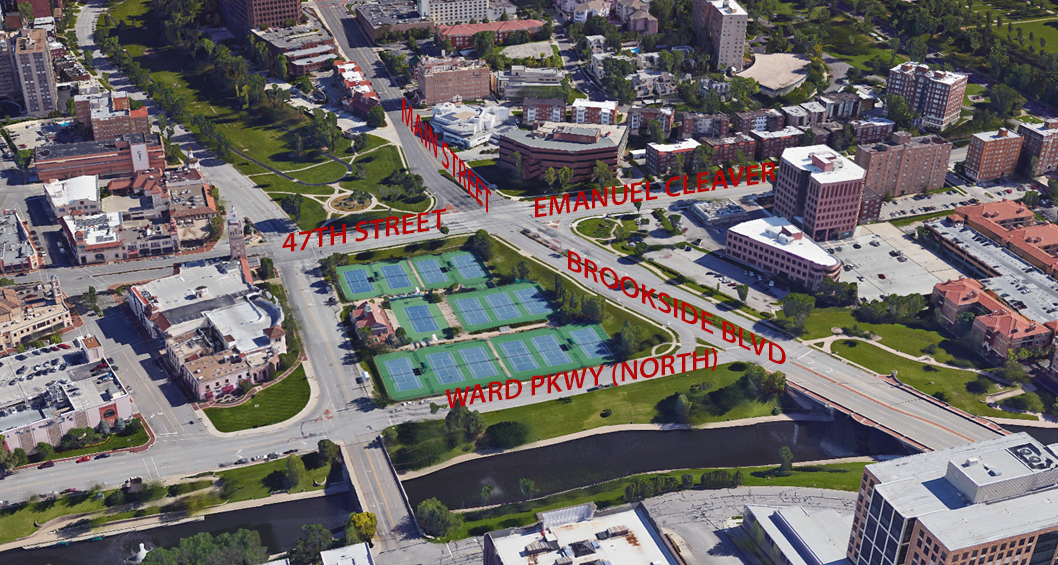
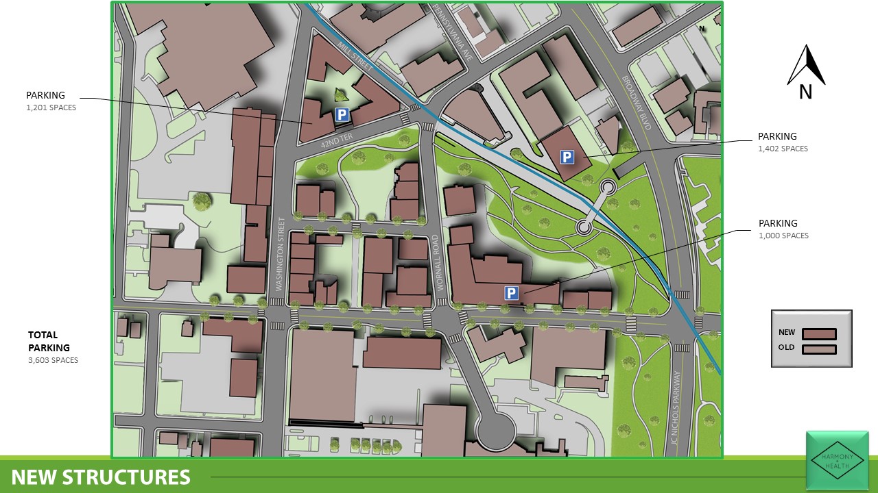
Below is the site plan for this area, which differentiates between new and existing structures. The main focus of this plan is to rid the area of the undersireable developments, including the apartment homes along Harrison and Campbell Streets, and the poor commercial variety along Troost, and redevelop this area in such a way that would reflect both the historic context of the surrounding neighborhood, as well as acknowledge the cultural presence from surrounding institutions.

FinalPlan_Massing
Site Plan – Massing 1:40

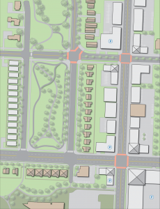
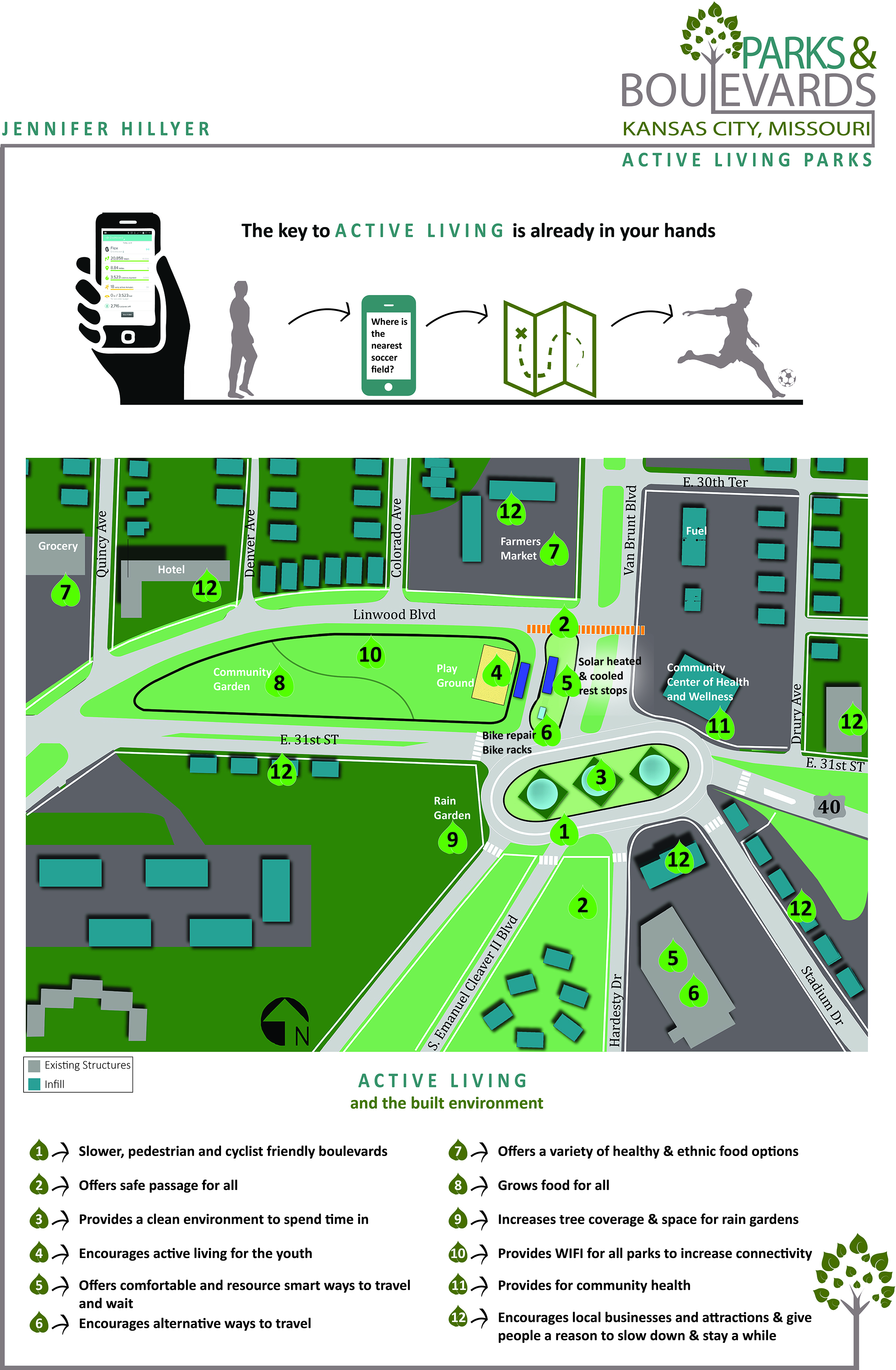
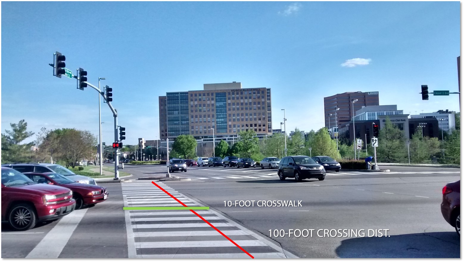
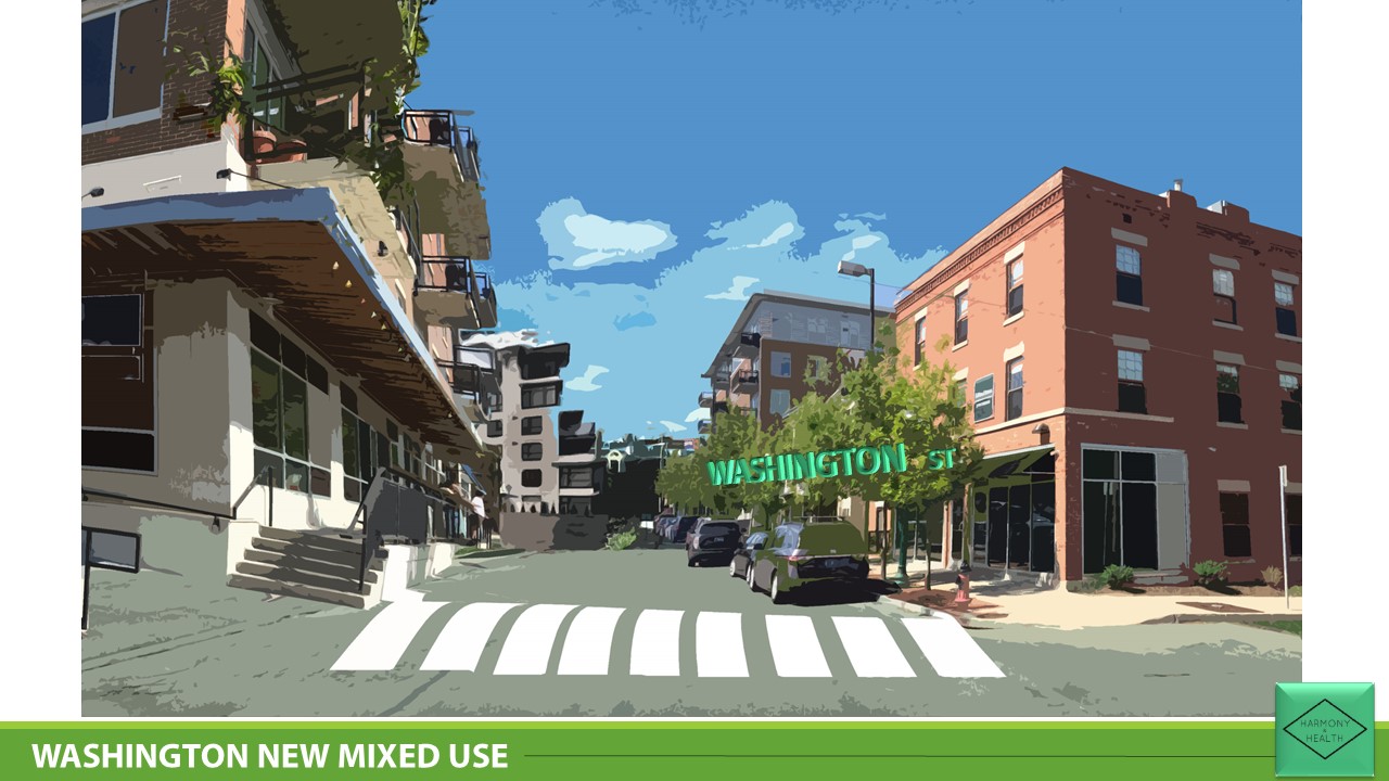
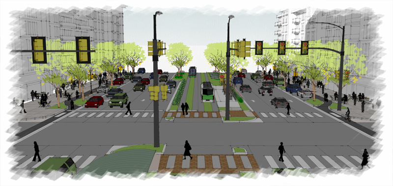
By extending Gillham Park, this plan has added an additional 156,000 square feet of space to Kansas City’s park inventory. On top of that, a proposed half mile of pathway, and addiontial 1.5 miles of bike trail would connect pedestrians nearly two miles from Emanuel Cleaver to Armour Boulevard. To support the increase in pedestrian activity, the portion of the Troost Corridor from north of Brush Creek Boulevard to Emanuel Cleaver has been redeveloped to include a healthy mix of retail, office, and residential, with a heavy focus on mixed use developments.

FinalPlan_LandUse
Site Plan – Land Use 1:40

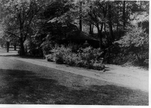
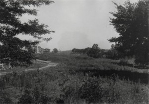
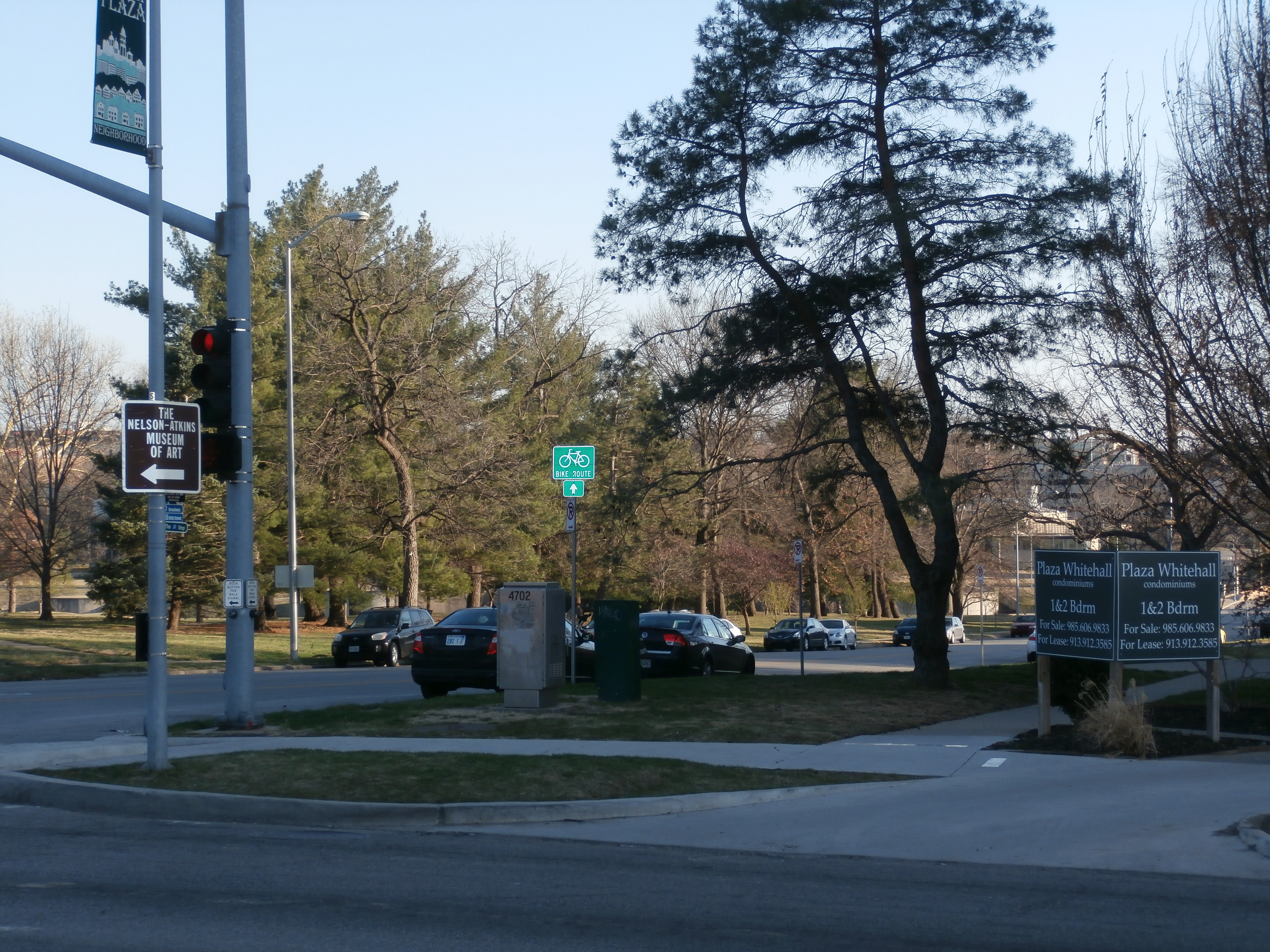
An important aspect of this design focuses on the historic context of this area as a whole. With the Rockhill and Southmoreland Neighborhood just to the west, this area is home to a number of historic charactristics, from the unique building styles and materials, all the way down to the historic stone walls that surround the majority of the adjacent homes. Using this as a means of connecting this area to the rest of Kansas City as a whole was done through the bike trail that runs from Emanuel Cleaver, north to Armour Boulevard. In researching some of the history of this area, I came across some historic photographs depicting an old wagon trail that ran through both Gillham Park and Hyde Park

B_G2_029
Hyde Park, looking South to 38th Street (1910)


Picture2
39th Street and Gillham Road, looking Northwest (1904)

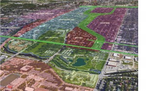
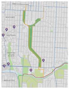
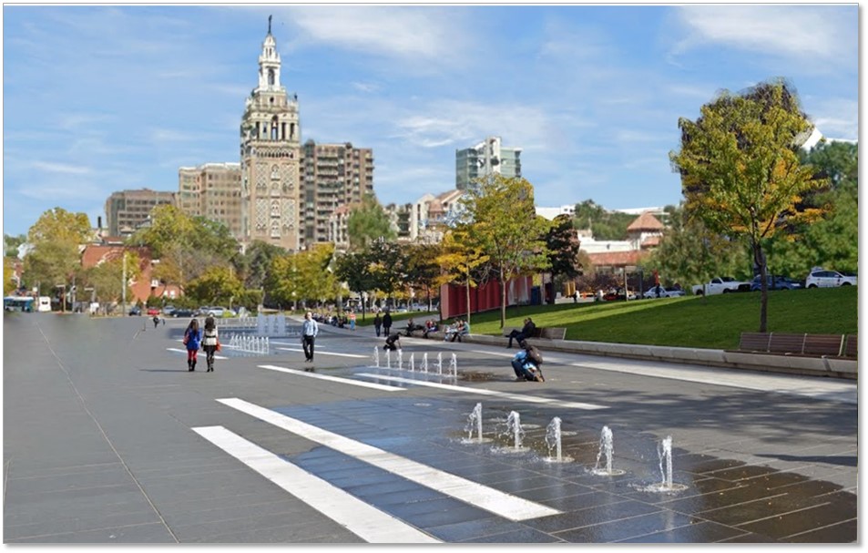
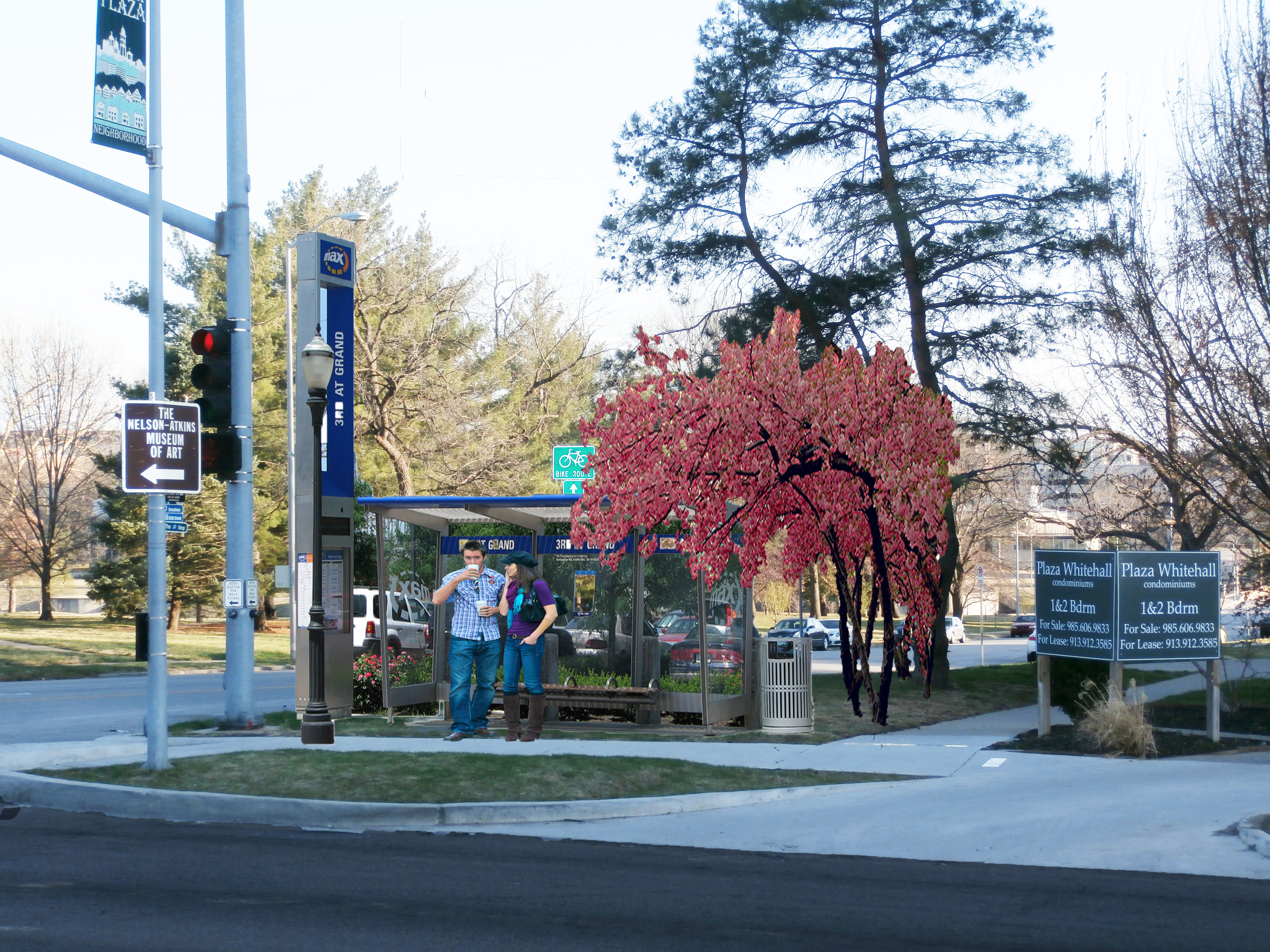
The bike trail begins at the intersection of Emanuel Cleaver and Campbell Streets, and traces the Western edge of Gillham Park and Hyde Park. The image below depicts the interaction between neighboring bike trails in the surrounding area.  With the Brush Creek Trail just to the South, it acts as an East-West connector to the Trolley Track Trail, which continues into the southern portion of Kansas City

BikeConnectivity
Trail Connectivity


As a whole, this plan was designed to serve as a resource for the neighoring residents, to better connect them with the surrounding area.  By creating this connection within the Parks and Boulevards System, this area would indefinitely experience a high influx of both residential and commercial activity. With a cultural presence on Troost from the Nelson Atkins Museum and the adjacent institutions, it would serve as a potential catalyst for future development and revitlization of the Troost Corridor.


Active Living & KC Parks & Boulevards

Kansas City Parks and Boulevards system was conceived of in a time when people did not have to think about ways to incorporate active living into their daily lives- they just lived actively, and no one had to plan for it. At the time the boulevard system was envisioned the car was a technological marvel and though fascinating most people thought they could never afford one and therefore no one foresaw the impact that that single invention would have on society, the built environment and the planet as a whole. With the explosion of vehicles on the roads, the invention of air-conditioning and other technological wonders that have made life easier but at the same time have made life more sedentary. Today we are challenged with finding ways to become more active and live healthier lives.

One way path to active living that is becoming increasingly more popular is the use of Smart-phone applications and technology like “Fit-Bit” to motivate, track and increase physical activity. This wave of technology became one of my inspirations for this semesters project. I started asking questions: What if through the use of well designed applications caught on in a big way and Kansas City got active in a completely different fashion? What would the demands become of an actively living society? What would that look like for Parks & Boulevards in 20 years?

I imagine people biking, walking and riding buses or other transit to work, school and for fun. These people know their neighbors and spend time outdoors together as a community. They are eating healthier, planting gardens and spending less money on fast food and investing more in environment. They are connected across communities in ways that are entirely different from how we experience the city. What are the things these people would require in order to support this lifestyle?

Basemaps roads FINAL Final with plants
Existing Streets and Buildings at Site

To answer those questions I created an overlay that focuses on elements of active living that could work anywhere in the city. Those elements are transportation, environment, physical health, technology and safety. At random, I chose a place within the 1940’s boundaries of Kansas City (it just looked interesting on the map) and by the time I realized I’d probably picked one of the hardest nodes in the city to test my theory on. I’d already done too much work to back out! But I quickly concluded that if the overlay could work here it can be done anywhere in the city.

The node I selected is the convergence point for 7 significant roads; Linwood Boulevard, Hardesty, East 31st Street, Highway 40, Stadium Drive, Emanuel Cleaver II Boulevard and Van Brunt Boulevard. It’s pretty much ground zero for the terrifying road epidemic in Kansas City. The community has been divided by Highway 70 and some parts of it have been cut off completely from their original neighborhoods. Many of the homes are in poor condition and there are several schools in the area that have been closed for good.

But the place has excellent bones!

Site Sketch
Looking South down Emanuel Cleaver II Boulevard from McDonald’s Parking lot on Van Brunt Boulevard

I didn’t realize it until I spent time there but this place has enormous potential that will not be hard to tap into. The foundation is solid. It being the convergence point of many heavily used roads makes it an ideal place for redevelopment in general. It has perfect access to Highway 70 and Highway 40 (which serves as the portal to the city coming in from the east). It also has a lot of park and green ways, old trees and astounding topography. This intersection has a moderate population that is made up of three neighborhoods; Boulevard Village, Knoches Park, and South Blue Valley Neighborhoods. It already has an active transit stop and the McDonald’s that sits in the midst of it all seems to act as a community center. It has great zoning and landuse already in place and with that comes a smattering of businesses both local and corporate and close proximity to the VA hospital. With lots of empty space it is just begging to be activated in the community.

I do not own a car. I gave up driving more than a year ago as an experiment that has turned into a lifestyle in which I go everywhere in my life with a bike and my feet. I tell you this because I want you to know that I am engaged in the transit system in many ways and am invested in having it be a better experience for all of us. With that in mind, The first thing I tackled was the hot mess of a mess that is that intersection. The convergence of these roads is confusing, scary, inefficient and people drive way too fast through that area. Boulevards are great with their wide and gentle winding roads and I’m sure they were lovely from a horse and carriage or a car that went about as fast as one, but today with top speeds being much higher those fabulous roads inspire speeds to be tested… And people do. So, maintain the integrity of the Boulevards, slow people down and try to confuse them less, became the goals for this phase of applying the overlay. I played with many options but the one that works the best is an oval shaped roundabout. Roundabouts slow traffic down by nature of design, so it will make the area safer for those of us who don’t drive and for those who do. They also look nice and give drivers more options for connection than the current street design does. The oval shape allows for all of the current streets to connect while maintaining the structure and design of the Boulevards.

Basemaps roads FINAL Final with plants
Oval Roundabout Intervention- tilted to efficiently capture all of the streets.

The next idea has to do with the bus stop and the park that is connected to. Turn the bus stop into something useable and interesting. Bus ridding and waiting doesn’t have to be annoying, uncomfortable or boring. We should start creating active bus stops and integrate them into the fabric of the community. 1) Bus stops need to have Wi-Fi -if not the entire park. 2) Stops should be solar heated and cooled 3) Support multiple forms of transportation uses 4) be attached to an interesting and attractive playground or at least a swing set whenever possible.

The park itself can be so many interesting things like a playground for all ages and a community garden with a running track around and through it for starters. It is a beautiful green space that could be the heart of this hub.

Basemaps roads FINAL Final with plants
New playground, Wi-Fi, running track, bike racks, bike repair, and solar cooled and heated stops.

The third idea, and from my pedestrian bus riding perspective, and the most crucial is a crosswalk. Currently the crosswalk is right in the middle of the tangle of roads. It is also up quite a steep hill especially for someone in a wheel chair and the sidewalks are not complete or useable for someone who is impaired in anyway. Where people are crossing instead is directly from the bus stop, across traffic and medians and winding up in MacDonald’s parking lot. This doesn’t work. I watched several people almost get hit and a man in a wheel chair navigating across the street where I am proposing a pedestrian crossing, at which, there are currently no lights. But there aren’t any reasonable options at the moment. My suggestion is a crosswalk with stop lights at the intersection of Linwood Boulevard and Van Brunt and add in thick, impassable shrubbery in the way of the current natural path to encourage people to use a safer route.

Basemaps roads FINAL Final with plants
Crosswalk at Linwood Boulevard and sidewalks

 With some investment this place can bloom into a true hub of active living in Kansas City.

Basemaps roads FINAL Final with plants
Complete Future Site Plan including commercial and residential overlay with water cleaning/ purifying fountains

As more and more investment is made in the area, businesses and developments will pour back into the space allowing for more improvements to the area. Improvements such as: reopening schools, farmers markets, theaters and business catering to healthy living. Perhaps we will evolve beyond fast food and a  health and wellness community center can replace the McDonalds that currently resides on the most connected corner with the some of the best street views in the city. And that’s just the beginning…

Print
Active living overlay map of site


The 21st Century Hospital Hill Park: Reimagining The Crown Center District

Historic Conditions

Before George Kessler designed the framework for Hospital Hill Park in Kansas City and incorporated the space into the city’s Parks and Boulevards System, a former park-like space existed atop the hill on the grounds of the Kansas City General Hospital campus. Despite a location directly between General Hospital no.1 and no.2, the space, then referred to as City Hospital Park, had little utility in functioning as a true public space like more modern parks of today. As decrepit conditions at Old City Hospital which served the city’s Black and Mexican populations continued to erode, a new hospital was constructed just north of the existing Kansas City General Hospital that served the city’s white citizens. Nationally acclaimed as one of the first medical facilities built to cater specifically for black medical faculty and patients, General Hospital no.2 was a vast improvement over the former facilities, yet lacked technology and staff training to match the degree of care provided at white-serving General Hospital no.1. City Hospital Park was created with the development of General Hospital no.2 that framed the undeveloped green space next to General Hospital no.1.

Hospital Hill, Kansas City, Missouri Print

“Postcard of Hospital Hill showing the green space of City Hospital Park, Missouri Valley Special Collections”

Although intended to serve as public space at the city-funded hospital campus, declining race relations and political corruption fueled a tense segregation between the two hospitals that led to led to decreased utilization of the space. While Kessler began the planning and design of nearby Washington Square Park, hospital administrators transferred the park along with surrounding parcels of land to the Kansas City Board of Parks Commissioners. Kessler than had the authority needed to design a more functional park space and connect it to the boulevard system via Gillham Rd.

Existing Conditions

Kessler’s efforts at transforming the racially segregated buffer space of the former park was successful in 1942 as the newly designed park was christened with a new name, Hospital Hill Park. With the changing framework of hospital ownership and administration, the name captured the changing character of the area as multiple hospitals and educational institutions located around the former General Hospital campus. Despite overcoming the initial barriers of the former park, Hospital Hill Park faced a new set of challenges that would become further antagonized by the parks urban location and changing built environment. With large scale development occurring at Hospital Hill, Hospital Hill Park’s boundaries began to be pushed to the corner of 22nd St and Gillham Road and threatened with encroachment from nearby Children’s Mercy Hospital, which expanded to the park’s southern and eastern boundaries. At the close of the 1960’s, Donald Hall and executives from the Hallmark Cards Company identified the blighted commercial areas just west of Hospital Hill as the new location for their master planned corporate headquarters. Envisioned as a new ‘’uptown’’ retail and corporate center for Kansas City similar in nature to the Country Club Plaza, the new development of the planned ‘’Crown Center’’ development began to change the composure of Hospital Parks remaining untouched borders. Despite the park’s once strong connection to the rest of the boulevard system in Kansas City via Gillham Road, development from Crown Center dramatically altered the terrain and intensified the elevation difference between the park and neighboring development. Today, the current boundaries of Hospital Hill Park have been pushed to the limits, neighbored not just by development, but large-scale super block expansion at Children’s Mercy Hospital and Crown Center that has overlooked adequate connections to the park. Now diseccted by Gillham Road which experiences much higher levels of traffic than Kessler anticipated, the park sits isolated in an area of the city that has some of the highest density of potential users. In the census tracts making up the Hospital Hill and Crown Center Districts, there are nearly 23,000 employees. Of these employees, only 233, or 1%, live within the area’s census tracts. Additionally, of the remaining 99%, nearly 17,000 commute more than 10 miles from the offices and hospitals in the Crown Center District. In areas where there is a high concentration of commuters and employees, parks and public space play an especially important role in providing organic and accessible space to people outside of their homes.

Crown Center Common, the 21st Century Design of Hospital Hill Park

To address the current challenges to the park after 75 years of being overlooked and inadequately connected to its surrounding urban fabric, I envisioned an ambitious connection plan with Hospital Hill Park at the focal point. Taking note of the historical boundaries of the park, the plan calls for the addition of former park board land that has been marooned by the multiple traffic lanes of Gillham Road and Pershing Road. By sinking the existing traffic thoroughfares into a cut-and-cover tunnel, park space can be built above over the sunken roadway and expand the boundaries of the park from the edge of Children’s Mercy Hospital directly to the edge of hotel and office space at Crown Center. Removal of the roadway will also allow terraforming in certain areas of the park to create a more manageable pedestrian and bike connection between the two districts. A newly created bikeway winds through the organic park space to provide a new park amenity and further connect the park to the surrounding areas. By adjusting the elevation at which park meets built environment, existing development in Crown Center has the opportunity to connect into the park which is envisioned through the construction of a retail promenade at the Pershing Road Office complex.

IMG_7583

Unconstricted by the former roadway that paralleled the ground level of office space, the new park could meet at the various levels at which the Pershing Complex connects with Crown Center Square. Repurposed space from office to retail could be sustained through the direct access to Crown Center Shops and Square and the large parking structures that are submerged beneath the office complex. Additionally, the existing hotel that would border that park in this design, the Crown Center Sheraton, could bridge into the park by construction of a new outdoor plaza and lagoon, further increasing the park as an area amenity and increasing utilization of the park. New development at the site would be in response to the high level of commuting employees in the area. Two new residential mixed-use towers would be constructed to house more of the areas employees and increase activity and eyes on the park, benefitting the park in terms of both use and safety. Office space on the ground floor of the towers could accommodate commercial office or institutional use currently demanded by Crown Center institutions.

IMG_7577

Overall, the new vision of Hospital Hill Park would address the inattentive development that occurred around the park and reconnect the space into the Hospital Hill and Crown Center Districts. New connections would support a revitalization of existing developed space and propose an opportunity for the emergence of a new phase of residential and commercial development in an area sometimes thought of at build out. Such a second phase of Crown Center and the institutions at Hospital Hill could be supported by major stakeholders such as the Crown Center Redevelopment Corporation, Children’s Mercy Hospital, Truman Hospital, UMKC, and the various insurance companies that house their Kansas City operations in Crown Center. With a vested interest in the success of public spaces and the opportunity for catalyst potential, these influential stakeholders will play an important role in the reimagining of Hospital Park and its transformation into a 21st century park of Kansas City.

Penn Valley Parkway

For the  2015 JC NicholsPrize project we were assigned to choose an area from the 1950’s boundaries of Kansas City, Missouri Parks and Boulevards system and create a new plan for the 21st Century. The location I chose is the interchange between Broadway, Southwest Trafficway, and I-35. I Chose this ocation because I wanted to try and make a feasable plan for the removal of I-35, and bring life back to the Westside neighborhood that had been blocked off by the massive wall created that is I-35.

My first order of business was to find the best location to reroute I-35. Below in Image 1 I chose to connect it northwest to the interchange of I-70 and I-670. I also adding a few other minor changes with the rerutefurther north. By rerouting I-35, the Westside neighborhood is opened back up to the Crossroads Arts District and Penn Valley Park. And is allowed to infill the land with new residential housing. The estimated cost for this portion of the project is around $328,000,000.

Image 1. Reroute of I-35 from Kansas City, MO to Kansas City, KS

The next phase of the plan is the transition from changing Southwest Trafficway to a Parkway, and adding infill housing to the Westside South neighborhood. The two and a half block area where the interchange was at I added a new multi-family housing neighborhood to increase the population density but still protect views by keeping the structures under 4 stories. A new loft was added next to Annies with underground parking and a statue was added to be a landmark for George Kessler. And finally the lake was raised to help control flood water, and the creek valley was raised even higher to allow a better sight angle for pedestrians and to provide a beautiful waterfall for an added element to the the lake.

Below in Image 2 you can see the plan for the model area and where detailed changes were made. Also in Image 2 is the addition of a streetcar line running along Penn Valley Parkway, and the bus line as well as the UMKC Concervatory shuttle along Broadway with a stop at the southeast corner of 26th street. For bike lanes, the current signed bike route along Penn Dr. has been made faster and safer with the addition of Jefferson street so the riders do not have to cross the new Parkway they can ride two blocks further north and cross under the bridge. I have also added bike lanes along Broadway and Penn Valley Parkway.

Plan-01-01
Image 2. Plan with Transportation

The housing in the plan would add  385,900 square feet of residential housing at an estimated cost of $31,643,800. The commercial adittions would have an increase of 53,600 square feet at an estimated cost of $4,824,000. Seen below in Image 3 is the Land-usemap showing the location of the different building types.

Land Use Map-01-01
Image 3. Land-Use Plan

With the removal of I-35 the Westside neighborhood is reconnected to the Crossroads Arts District and Penn Valley Park and creates a more healthy and livable environment where walkability and all modes of transportation are welcomed.

Seville Circle: Realizing the Fuller Potential of the Parks and Boulevards System

Kansas City’s most popular place is the Plaza. When it’s summertime, it’s a evening stroll in the shadow of the district’s many towers. Come Fall, it’s the Art Fair, then soon it’s the holidays and the Plaza Lights. Kansas Citians love the Plaza — for many of them, it’s the real heart of the city — even more than downtown.

IMG_4304

Sadly, while the Plaza is be one of the most popular and best-designed spaces in the city, some of the space directly adjacent to the great district is very poorly designed and, consequently, avoided by visitors. Perhaps even worse is that the space includes major elements of the Parks and Boulevards System, including Brookside Blvd, Emanuel Cleaver Blvd., Ward Pkwy, Mill Creek Park and more.

streets

Above is a birds-eye view taken from Google Earth. If you blow it up (click on it), then you’ll be able to see the Plaza’s iconic Giralda Tower on the left-hand side. North follows Main Street out of frame.

The space between the tower and where buildings resume to the east of Brookside Blvd is a crucial crossing point into the Plaza from points east. The closest and most prominent of the these is the Nelson-Atkins Museum of Art, the lawn of which you can just make out in the top-left corner of the photo above.

You wouldn’t be faulted for thinking that visitors on foot might want to cross from the Plaza to the Nelson or vice versa on a Saturday afternoon. And yet we’ve created a pretty terrible space for that.

47th and Main

This is 47th Street/Emanuel Cleaver (left to right) at the intersection of Main/Brookside Blvd. (As the names changes of the streets might suggest, this is a key coming-together point.) The streets are a minimum of six lanes wide.  There are left turn lanes in all directions and even a couple channelized right-turn lanes (northwest and southeast corners of the intersection). While this makes for a more comfortable ride in a car, it’s awful if you’re on foot — you have to cross 100 ft. in any direction in this intersection. What’s worse is that, up until very recently, the most minimal style of crosswalk striping was used.

crosswalk

The result? Crossing as a pedestrian at maybe one of the most important intersections in the city is a scary, dangerous experience.

The heavily car-oriented design of the adjacent streets means that we get a situation like this — two boulevards (Emanuel Cleaver and Brookside) creating a physical (and really, psychological) disconnection in one of the city’s otherwise great neighborhoods:

disconnection

That’s not all, though. While the south end of Mill Creek Park (across the street to the north of the tennis courts) is a pleasant, inviting space, we’ve put a fenced-in set of tennis courts (owned by the parks department) to the south of them, denying the opportunity for an excellent public space connecting the park to Brush Creek on the south.

(Right now, buses from all over the city converge around the tennis courts. If someone wants to transfer from one bus to another, they have to around the tennis courts to find their next stop.)

How do you address these issues?

What about with this?

reduced plan

A roundabout at 47th and Main, accessible to pedestrians, like Columbus Circle in New York:

columbus circle

And yes, move the Nichols Fountain to the middle of it. Give the fountain the prominence it deserves. (Mill Creek Park, meanwhile, would have room to expand for new, exciting uses.)

Why a roundabout? Not only is it monumental, it allows roads around it to be reduced in width because the roundabout works as left- and right-turn lane in one — six or seven lane Brookside Blvd can now become just four.

With wider crosswalks and generous crossing islands, the trip for pedestrians and cyclists is safer, too. (It’s also quite a bit more of an “event,” with the roundabout in the background.) The yellow line on the plan indicates where the Trolley Track Trail could finally pass through.

Meanwhile, why not a new public square to the south, something that might look like this (it’s photoshopped):

square

The public square could connect Mill Creek Park to Brush Creek. And unlike the existing tennis courts, it would be much more “plaza” than “country club,” as such a spot — so close to the action of the Plaza — should be.

For an east-west connection, why not an artisan or book fair down the middle of the street? There’s room, and this would create interest, activity, and a very real connection towards the Nelson-Atkins Museum. (Check out this precedent in Buenos Aires; also an existing proposal to put such a fair on the north side of 47th Street arbitrarily favors one side of the street, while putting high-intensity activity in the front yard of apartment-dwellers there.)

The city’s streetcar — perhaps expanding as far south as UMKC someday — would dip underground for a few hundred feet near the roundabout (dotted blue line). Crucially, most buses could now stop at one point, while interfacing easily with a streetcar “subway” station below.

transit


New opportunities for development arise if the area to the southeast of the roundabout — currently rather awkwardly built on — is rearranged to better acknowledge the Plaza and become part of the event that is the roundabout.

Feasible?
In all, the idea might seem a little “out there” but it’s a vision for how the Parks and Boulevards can better serve the city that it’s supposed to connect.

Cultural Bridges: A Brush Creek Intervention


Context map showing 1/2 mile radius around site

If you study any subject for a day or two, you will most likely gain a basic understanding of what it’s about, and learn the key aspects (be they assets or liabilities) associated with it. But studying a subject for months broadens your perspective so much further, delving beyond the surface to discover how people and the environment are affected and finding improvements or all-together new solutions for the problems.

Examining the conditions of Kansas City’s Parks and Boulevards system for the past 4 months has helped to confirm for me that planning for the location of a tree is just as important as planning for the location of residences and businesses, in any city. My proposed intervention, near the intersection of Brookside and Volker Blvd., included not only changes to buildings and streets, but to green space as well (Frank A. Theis Park). The main idea was to increase connectivity across Brush Creek and the surrounding area, and to promote socioeconomic diversity and physical health within the area’s large young adult population.

My overall concept began to piece together for me when I came across an article that listed the 50 healthiest college towns in the U.S.. The features that each town had in common were bike trails and other public options for physical activity and recreation, and access to a variety of healthy dining options, from farmers’ markets and fruit stands to restaurants that centered around cleaner eating. Adding some of these features to my site could be part of the solution (or at least the catalyst of a solution) to bringing the Parks and Boulevards system up to date in this 21st century.


OLYMPUS DIGITAL CAMERA
Current bus stop west of Theis Park, @ corner of Oak St. and Emanuel Cleaver II Blvd.


OLYMPUS DIGITAL CAMERA
Proposed BRT stop west of Theis park, @ corner of Oak St. and Emanuel Cleaver II Blvd.

In addition to connecting and extending the existing bike trails, I focused on maximizing the efficiency and convenience of Kansas City’s public transportation system. Currently, the Bus Rapid Transit system (BRT) is very limited in its service routes. By expanding the service beyond the Main St. and Troost Ave. lines, and including the entire Parks and Boulevards system in a new initiative, ridership would increase, which in turn would help in decreasing automobile dependency.


UPD 312 Pic for blog
Site plan


As seen in the site plan, more infrastructure enhancements included creating more ease of vehicle and bicycle movement across Brush Creek, by extending McGee St. and Locust St. southward to Volker Blvd.; I also connected the east and west portions of E 48th St., in the process dividing Theis Park into 2 separate sections. To help the park maintain a sense of oneness in spite of the split, wild plum trees would be planted in a design that brought attention to the entrances for both sections of the park, which are directly facing each other.


OLYMPUS DIGITAL CAMERA
Before proposed intervention @ Brush Creek in Theis Park
OLYMPUS DIGITAL CAMERA
After proposed intervention @ Brush Creek in Theis Park


And in an effort to keep in character with the artistic nature of nearby attractions (the Nelson Atkins Museum of Art and Kauffman Foundation Garden), a music/performance stage would be placed in the southern part of the park, at the bottom of a sloping hill and near the water’s edge.

A feat that would require the cooperation of the owners is the slight repurposing  of the Fountain View on the Plaza apartments, an exclusive complex that caters to wealthier clientele. Yes, making money is the main goal of most business owners’ agendas, but as I learned in my study of urban planning theory, narrowing the divide of social classes and promoting equal housing/work opportunities for all citizens is what makes a successful society. This is the purpose of equity planning,  and actually adopting and implementing the principles of equity planning is what needs to be done as we move forward in the 21st century, instead of some of the ‘all talk and no action’ planning approaches of the past. I believe that redefining the future of the areas in JC Nichols’ Country Club District should include erasing the remnants of the old ‘red-lining’ mentality, and a possible step in that direction would be to include a wider range of affordability in the Fountain View apartment complex. As a much needed bonus, the lot adjacent to the complex, which now houses News 41 headquarters, would be designed as a farmers’ market, to support local farmers and provide quality, affordable produce to consumers more concerned with community networking than commercialism; it would be in direct competition with the Whole Foods that was proposed for Oak St. just a few blocks away.

Overall, the goal of my proposal was to provide a little more freedom of choice for young adults and people in general, in varying contexts: better public transportation choices, more choices in street routes, more choices in housing, and diverse choices in entertainment and recreation. It would be a refreshing augmentation to a site in Kansas City’s Parks and Boulevards system, with the potential to add property value to surrounding sites.

Harmony and Health

In designing for the 21st century parks and boulevards, our studio took several months to analyze and gather meaningful information. This gave us a well rounded insight into many of the strengths and weaknesses of the historic system.


My design intervention occurs at the intersection of J.C. Nichols Parkway and 43rd street. This ‘hot spot’ is the confluence of two highly trafficked districts in Kansas City.  With the shopping area of the plaza to the south, Westport entertainment district to the north, and the Saint Luke’s Hospital complex at its epicenter; the area has a history of morphing land use’s and transportation distributions.

Slide5
A history of issues.

In order to resolve the lack of connectivity and density in the area, I envisioned a plan to break through the current edges of the site and extend Mill Creek Park into Westport. This coupled with an increase of mixed use sites and the extension of the street car could rejuvenate the current desolation that one feels when walking through the area.


Slide6
Parti designed in SketchUp


The plan seeks to remove the current parking lots and add green space that encompasses a new street car route that will connect to the main street line. It also incorporates 3 underground parking facilities that will increase parking 3 fold.

Slide9
New structures versus current.

The proposed extension of the street car route from Union Station towards UMKC is set at about 3.5 miles. The added length that would extend the line into Westport would only add less than a 1/4 of a mile and could provide a large increase in ridership as well as a great option for commuting between midtown and downtown.

Here is an example of the changes in the built environment that I designed to maintain the typo-morphology of Westport.

Slide21
Before


Slide23
After


Another part of our studio design project requirements was cost estimates and phasing. I used RM Mean calculation books and the internet to find out current estimates for demolition and construction of buildings and infrastructure.


Slide24
Approx 116 million in cost.


This semester pushed myself and my classmates to not only understand different methods of analysis but to use them to be able to ask the right questions.
The site that I chose began to feel like an overwhelming endeavor of bottomless problems yet there were also some very clear solutions that seemed to resonate not only with myself but with the judges during the critique.
Slide18
Bridge for pedestrians.


To Be or Not To Be? That is the Boulevard Question

When looking for inspiration to give you ideas for a new design. I believe it is good practice to never limit yourself, and always keep an open mind. Because I am interested in creating a new design for a major corridor, Image 1 caught my attention by the way it focused on a car-oriented road, and wants to encourage walk-ability, high density development, and transit.

White_Flint_blvd
Image 1. A major corridor in White Flint, Maryland


Another good practice that has served me well in the inspirational process is not forgetting about the little things. There are many different elements to Parks and Boulevards, which my classmates and I have previously covered in earlier blogs. Signage is a small part of such a big system, but can be a major factor in the overall character. One as simple as seen in Image 2, can serve as just another indicator of how great a system we have.

bike-boulevard
Image 2. Boulevard Bike Route Sign


Resources:

http://albanybicyclecoalition.com/2012/06/

http://go.nbm.org/site/Calendar/295729932?view=Detail&id=116461

http://www.railwaypreservation.com/vintagetrolley/los_angeles.htm

The Five D’s and Beyond

Julie Campoli discusses walkability in her latest book ‘Made for Walking’. There are 5 elements that she’s states are vital in creating walkable neighborhoods. Density, diversity, design, destination accessibility, and distance to transit.


What she’s goes on to say is also very relevant to designing better urban spaces in the Parks and Boulevards of Kansas City,

” The five Ds make neighborhoods walkable, but a host of other attributes make them livable. Some, like open space, depend on larger systems that extend well beyond the confines of a neighborhood and require big thinking, long-term planning, and broad cooperation. Neighborhood parks are essential, but greater density demands more than that. It requires many varied, high-quality green spaces – large and small, formal and wild, for active recreation and solitude – that form a network across the metropolis and to wilderness areas beyond.”

Walnut Station
Mixed Use 43rd St Improvement Idea

When looking at the knuckles that our studio wants to improve upon, we have to not only use our analysis of the system as a whole but also intensive research of the particulars that each site might require. In order to nourish a diversity of high quality green spaces, large and small, we need to respond to each site’s specific qualities.

The low level of present population in the 1940 boundaries of KCMO

The largest lesson learned in a review of thematic maps on the status of the Parks and Boulevard System in Kansas City, MO is the low level of population within the 1940 boundaries of the city. In 2010, our study area with a population of just over 179,000 had almost the same population of Overland Park, Kansas with 173,000. Overland Park continues to grow and has reached 181,000 as of 2013 — a higher number than the 2010 population in our study area. In the 1940 Census Kansas City Missouri had just over 399,000 people. Our city has lost 220,000 people within our study area boundary. This is a 55% decline over the period and reveals a rate of decline of more than 1% a year.  The 1940 boundaries of Kansas City Mo are essentially the same as the 1909 boundaries. Our population today is 79,000 less in this area than our 1910 population of 248,000.

This has large implications on the capacity to maintain and restore the historic parks and boulevard system within this area of the city.

Sources: US Census Bureau 2015 Quick Facts,

US Census Analysis of the 100 Largest Places since 1790 (https://www.census.gov/population/www/documentation/twps0027/tab17.txt).

Student analyses in UMKC UPD 312 Urban Planning + Design studio.