Kansas City Parks and Boulevards system was conceived of in a time when people did not have to think about ways to incorporate active living into their daily lives- they just lived actively, and no one had to plan for it. At the time the boulevard system was envisioned the car was a technological marvel and though fascinating most people thought they could never afford one and therefore no one foresaw the impact that that single invention would have on society, the built environment and the planet as a whole. With the explosion of vehicles on the roads, the invention of air-conditioning and other technological wonders that have made life easier but at the same time have made life more sedentary. Today we are challenged with finding ways to become more active and live healthier lives.
One way path to active living that is becoming increasingly more popular is the use of Smart-phone applications and technology like “Fit-Bit” to motivate, track and increase physical activity. This wave of technology became one of my inspirations for this semesters project. I started asking questions: What if through the use of well designed applications caught on in a big way and Kansas City got active in a completely different fashion? What would the demands become of an actively living society? What would that look like for Parks & Boulevards in 20 years?
I imagine people biking, walking and riding buses or other transit to work, school and for fun. These people know their neighbors and spend time outdoors together as a community. They are eating healthier, planting gardens and spending less money on fast food and investing more in environment. They are connected across communities in ways that are entirely different from how we experience the city. What are the things these people would require in order to support this lifestyle?

To answer those questions I created an overlay that focuses on elements of active living that could work anywhere in the city. Those elements are transportation, environment, physical health, technology and safety. At random, I chose a place within the 1940’s boundaries of Kansas City (it just looked interesting on the map) and by the time I realized I’d probably picked one of the hardest nodes in the city to test my theory on. I’d already done too much work to back out! But I quickly concluded that if the overlay could work here it can be done anywhere in the city.
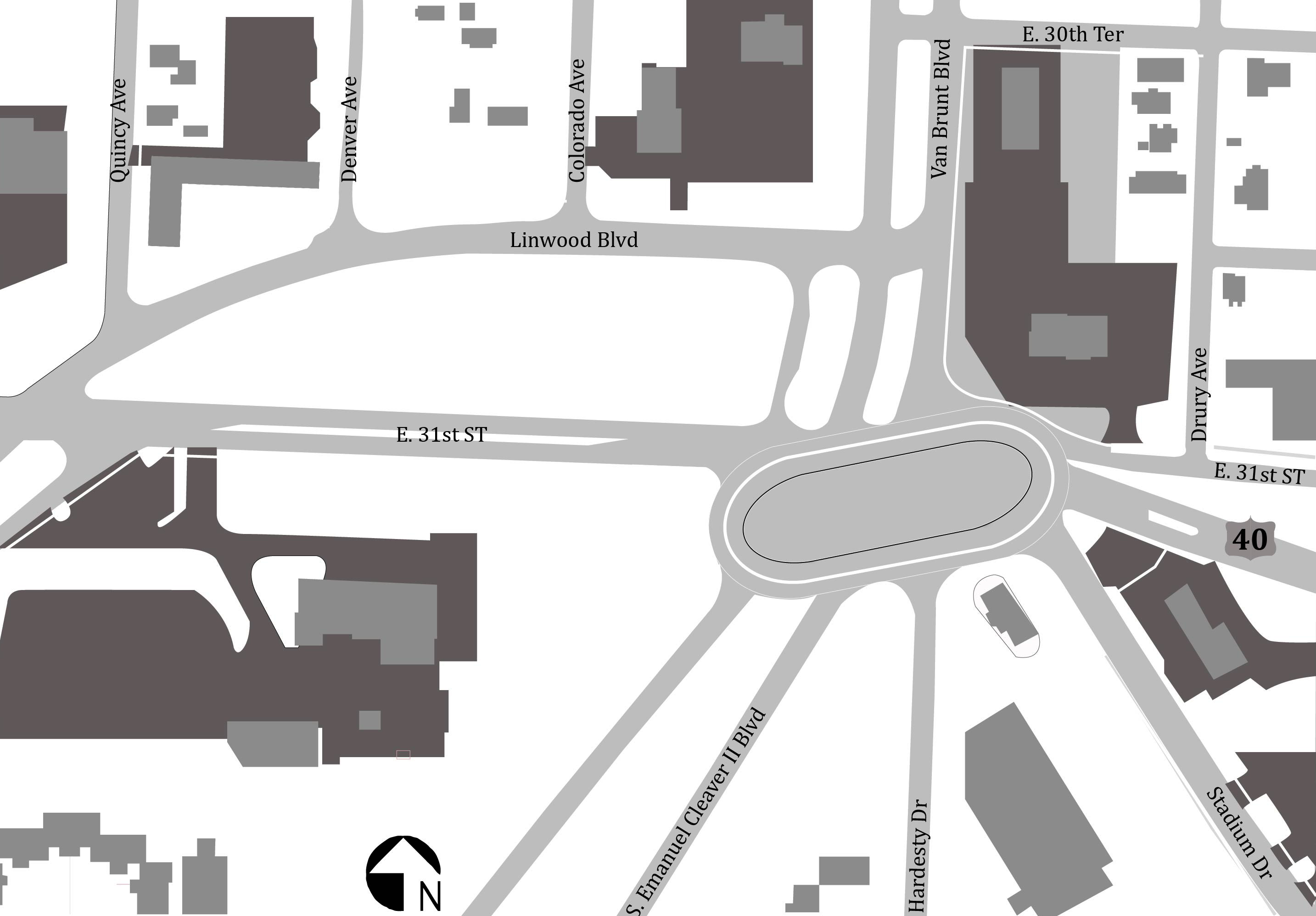
The node I selected is the convergence point for 7 significant roads; Linwood Boulevard, Hardesty, East 31st Street, Highway 40, Stadium Drive, Emanuel Cleaver II Boulevard and Van Brunt Boulevard. It’s pretty much ground zero for the terrifying road epidemic in Kansas City. The community has been divided by Highway 70 and some parts of it have been cut off completely from their original neighborhoods. Many of the homes are in poor condition and there are several schools in the area that have been closed for good.
But the place has excellent bones!

I didn’t realize it until I spent time there but this place has enormous potential that will not be hard to tap into. The foundation is solid. It being the convergence point of many heavily used roads makes it an ideal place for redevelopment in general. It has perfect access to Highway 70 and Highway 40 (which serves as the portal to the city coming in from the east). It also has a lot of park and green ways, old trees and astounding topography. This intersection has a moderate population that is made up of three neighborhoods; Boulevard Village, Knoches Park, and South Blue Valley Neighborhoods. It already has an active transit stop and the McDonald’s that sits in the midst of it all seems to act as a community center. It has great zoning and landuse already in place and with that comes a smattering of businesses both local and corporate and close proximity to the VA hospital. With lots of empty space it is just begging to be activated in the community.
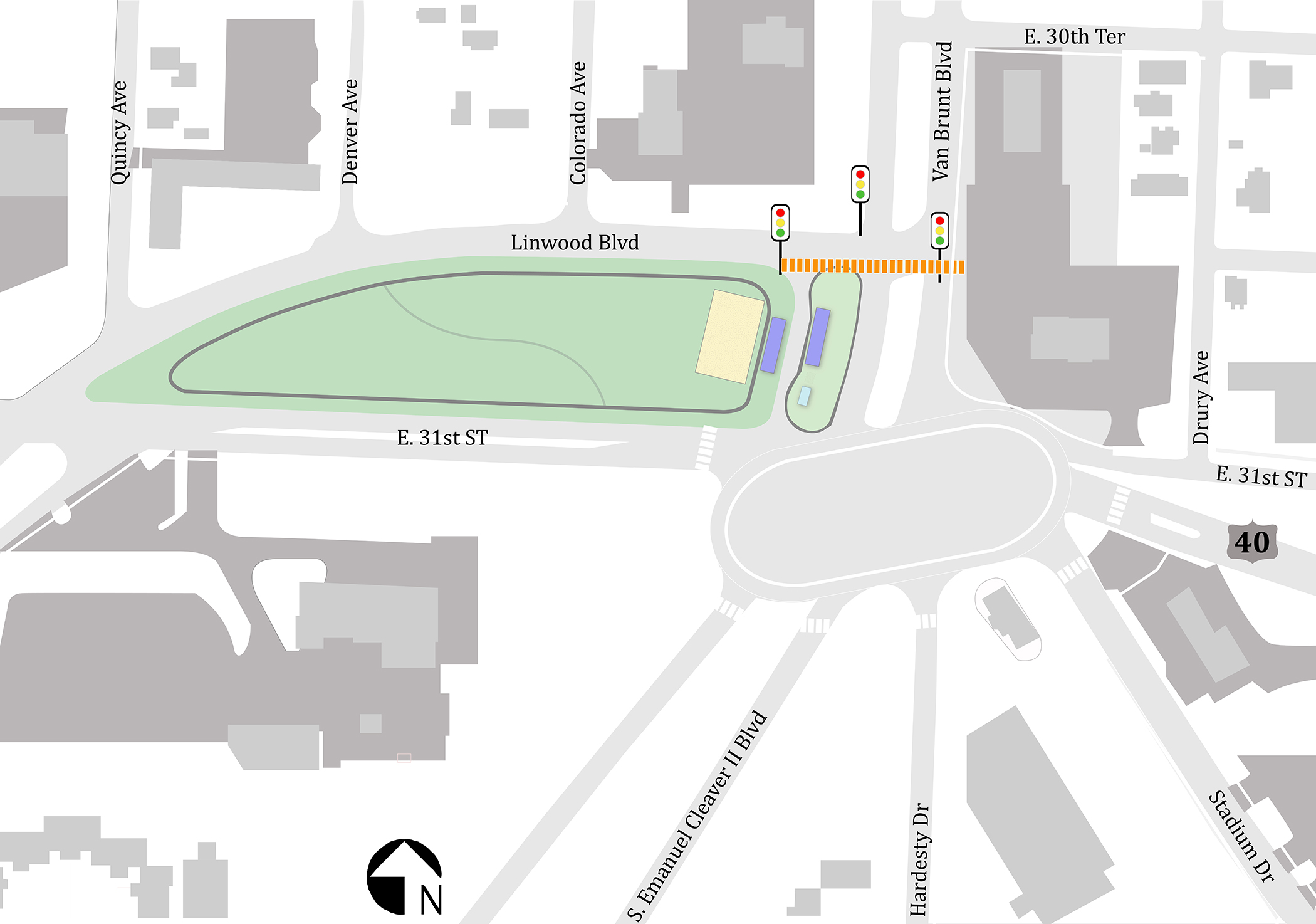
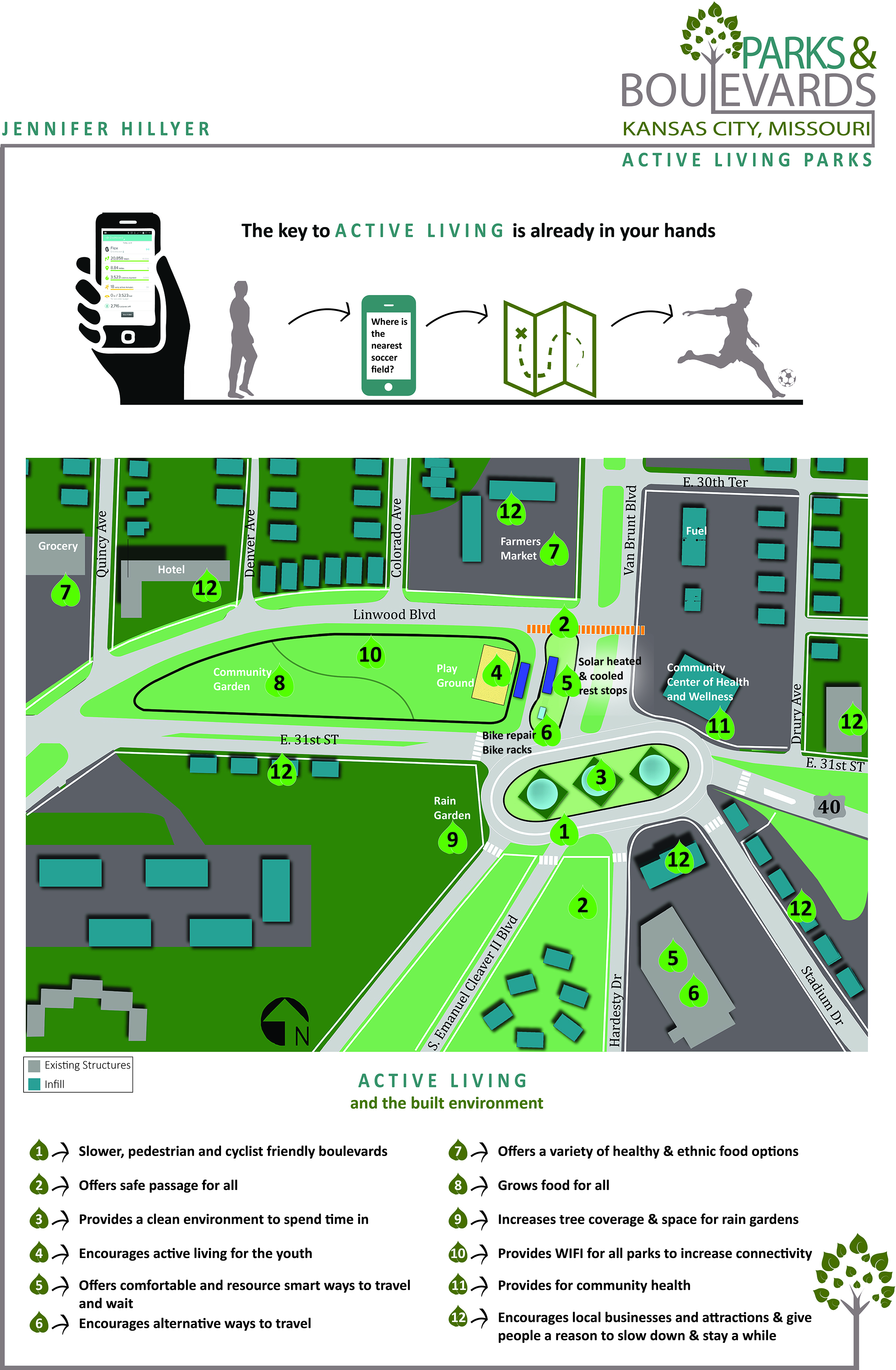
I do not own a car. I gave up driving more than a year ago as an experiment that has turned into a lifestyle in which I go everywhere in my life with a bike and my feet. I tell you this because I want you to know that I am engaged in the transit system in many ways and am invested in having it be a better experience for all of us. With that in mind, The first thing I tackled was the hot mess of a mess that is that intersection. The convergence of these roads is confusing, scary, inefficient and people drive way too fast through that area. Boulevards are great with their wide and gentle winding roads and I’m sure they were lovely from a horse and carriage or a car that went about as fast as one, but today with top speeds being much higher those fabulous roads inspire speeds to be tested… And people do. So, maintain the integrity of the Boulevards, slow people down and try to confuse them less, became the goals for this phase of applying the overlay. I played with many options but the one that works the best is an oval shaped roundabout. Roundabouts slow traffic down by nature of design, so it will make the area safer for those of us who don’t drive and for those who do. They also look nice and give drivers more options for connection than the current street design does. The oval shape allows for all of the current streets to connect while maintaining the structure and design of the Boulevards.
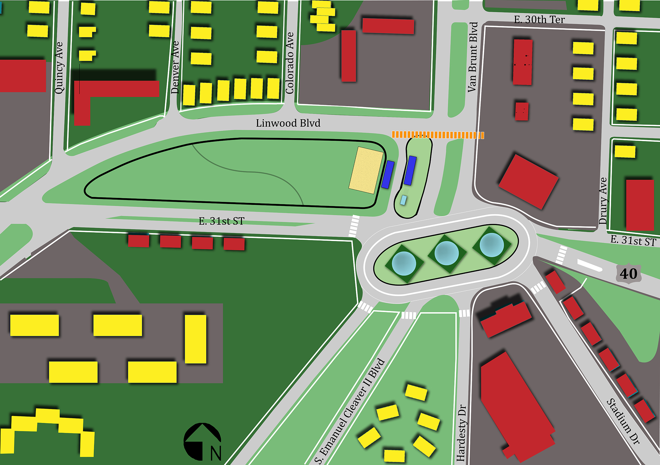
The next idea has to do with the bus stop and the park that is connected to. Turn the bus stop into something useable and interesting. Bus ridding and waiting doesn’t have to be annoying, uncomfortable or boring. We should start creating active bus stops and integrate them into the fabric of the community. 1) Bus stops need to have Wi-Fi -if not the entire park. 2) Stops should be solar heated and cooled 3) Support multiple forms of transportation uses 4) be attached to an interesting and attractive playground or at least a swing set whenever possible.
The park itself can be so many interesting things like a playground for all ages and a community garden with a running track around and through it for starters. It is a beautiful green space that could be the heart of this hub.

The third idea, and from my pedestrian bus riding perspective, and the most crucial is a crosswalk. Currently the crosswalk is right in the middle of the tangle of roads. It is also up quite a steep hill especially for someone in a wheel chair and the sidewalks are not complete or useable for someone who is impaired in anyway. Where people are crossing instead is directly from the bus stop, across traffic and medians and winding up in MacDonald’s parking lot. This doesn’t work. I watched several people almost get hit and a man in a wheel chair navigating across the street where I am proposing a pedestrian crossing, at which, there are currently no lights. But there aren’t any reasonable options at the moment. My suggestion is a crosswalk with stop lights at the intersection of Linwood Boulevard and Van Brunt and add in thick, impassable shrubbery in the way of the current natural path to encourage people to use a safer route.
With some investment this place can bloom into a true hub of active living in Kansas City.
As more and more investment is made in the area, businesses and developments will pour back into the space allowing for more improvements to the area. Improvements such as: reopening schools, farmers markets, theaters and business catering to healthy living. Perhaps we will evolve beyond fast food and a health and wellness community center can replace the McDonalds that currently resides on the most connected corner with the some of the best street views in the city. And that’s just the beginning…