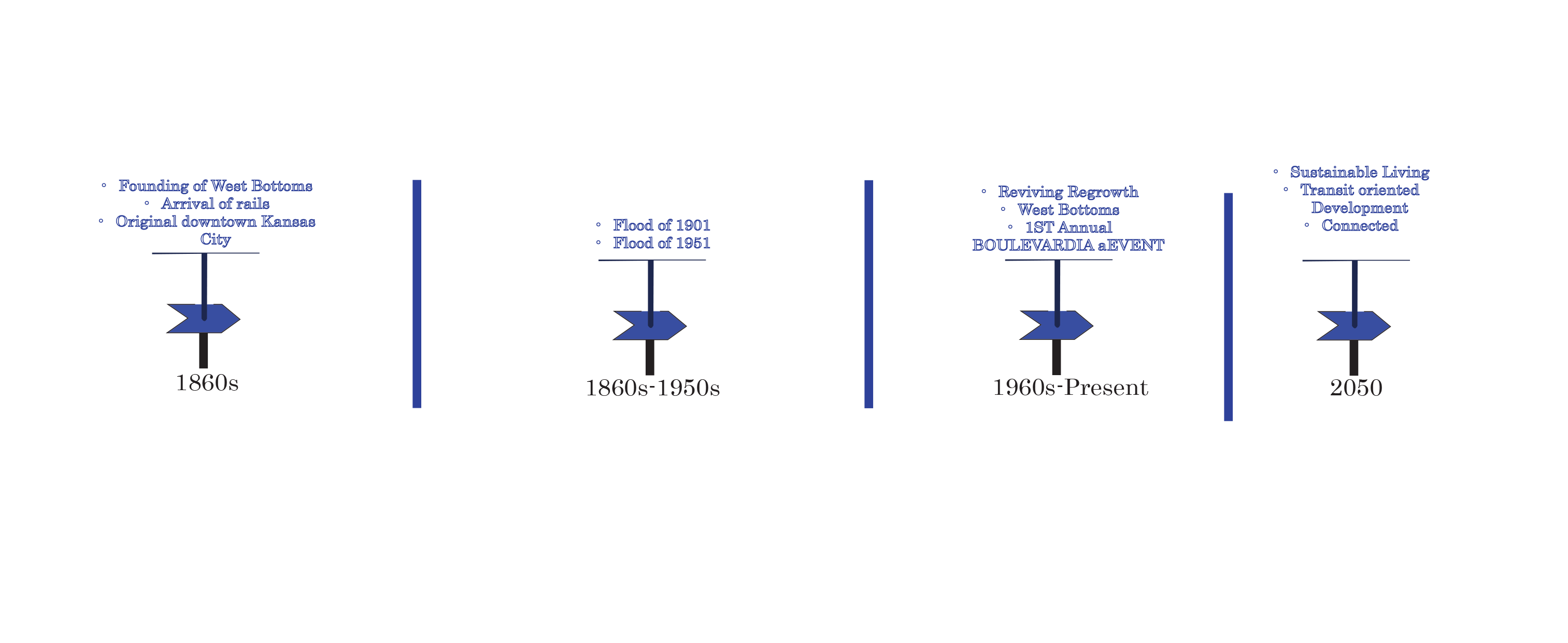
Images

The Viaduct: Bi-State Mobility Hub

For our final 312 studio project we were tasked to create a mobility hub along the Bi State Sustainable reinvestment corridor. Each studio was assigned a intersection from East in Independence Square to Village West in KCK.

Figure 1. History and Background

The West Bottoms has long been an industrial land use after the flooding in 1901 and 1951. All forms of residential land use were brought to what is now downtown Kansas City. The area has begun its regrowth and has become a potential residential development district again.

Figure 2. Existing land use, zoning and future land use.

Figure. 2 shows the existing land use, zoning, and future land use in the half-mile radius. The current area consists of a single apartment flat a few commercial and use and mostly industrial use. The future land use will consist of new residential and renovated ones over five. A few industrial uses will be kept on the north side of I-70. With new commercial development in the middle of the area.

Figure 3. Mobility Hub

The mobility hub is located at Mulberry and Highway 70.  In the blue is the transit center, with a pavilion that covers enough for buses. The design has bike lanes, sidewalks, trails, and improved crossing. Ample parking spaces for residents and visitors.

Figure 3. Highway 70 Redesigned Section

The obstruction disconnecting the KCK, and downtown Kansas City Missouri is the 7-lane  I-70. It currently only carries high-speed vehicular traffic. Considering that, inclusive transportation can not only connect the bi-state but also improve the environment. The 7-lane highway will be turned into 4-lane vehicles with reminding lines going to streetcar, planter, pedestrian path, and bike lane.

Figure 4. The Street Car Stop

The streetcar would direct connection to the ground and the apartments, with ample green space and pedestrian path.

Figure 5. Redevelopment District

Redevelopment district

Figure 6. Elevation of the Redevelopment District

West Bottom has ample connections from both sides of the states. It has highway 70 and highway 670 going through it. Its also got 12th Street, and Centra Bridge Ave that connect to downtown, City Market, redevelopment district, and industrial district.

Figure 7. Connections

KCATA has multiply routes in the West Bottom. With the new BRT in the West Bottoms, I extended the bus routes South of West of Bottoms to give residents other options besides driving personal vehicles.

Figure 8. Existing Public Transportation and Extended Route

The Implementations will be done in four phase. First we will begin the demolition phase to prepare for new development, and undergo brownfields cleanup and the area to prepare for new development. Phase 2 will start the new apartments development and the mobility hub along with redevelopment of I-70. Also extending the road network in the surrounding areas. Phase 3 will pick up after phase 2. with redevelopment district a renovating the existing infrastructure and converting those to new apartments. Phase 4 will focus on commercial land use, and any additional development to make that West Bottoms is thriving.

Phase 1
Phase 2
Phase 3
Phase 4

Troost Park Historical Analysis

The desired detail area that I was required to study was The Paseo to Tracy Ave , 30th to 31st Street. All of my maps were created on GIS and the base maps are either sanborn maps or atlas used to complete the analysis. By georefrecing these maps, I was able to compare the development of this area during different time periods.

1885 Historical Analysis Map

During the this time period, from the sanborn map that I was able to obtain only shows development along 31st street and a small amount of development in the actual Troost Park area. A huge thing to notice is The Paseo is not yet developed and was known as Lydia Avenue.

1925 Historical Analysis Map

This map was created by combining two photos from the 1925 atlas of my detailed study area. 30th street runs through the park and The Paseo. There are single family and multi-family homes being built around the park, along Tracy Avenue and the other side of Paseo. South of the park, 31st Street there is a continuation of more residential uses being built.

1950 Historical Analysis Map

The information contained from this 1950’s sanborn map is very bare, but it is evident that more of the homes were either vacant or torn down compared to the previous years that were studied. The park seems to be developing and the area south of the park.

1995 Historical Analysis Map

This map was created from a sanborn map and produced in GIS to examine the development of my area during the 1995 time period. Buildings that exist today are featured here in this photo, such as the Scottish Rite, KCPD, churches, and manufacturing companies. The development along the Paseo has sense increased, while development along Tracy Ave has dwindled.

2020 Historical Analysis Map

The 2020 Map shows residential development along The Paseo growing at a faster pace than Tracy Avenue, the transitional housing is a huge aspect for Tracy Avenue and this area in general. The development along 31st has not changed, KCPD is still in use and the Scottish Rite are all in good condition. One thing to notice are the many vacant parcels and lots along Tracy Avenue. Overall, the area is growing and still has potential for further development.

References

https://www.historicaerials.com/viewer

https://www.google.com/earth/

https://libguides.library.umkc.edu/az.php?a=d

Roeland Park Mobility Hub

Idea for Mobility Hub

A Pattern Language written by Christopher Alexander, describes the elements required of an mobility hub to be functional and holistic to the human experience. First, their must be a gateway into the neighborhood, suburb, or city. A gateway could be access through an arch or a awning trees guiding into the city. Two, there must be an available public outdoor room with a view of many homes, and a feeling that lingering and flirting is comfortable. For an example Italy’s plazas or a public square that provides access to the public water feature. Without a comfortable place for public flirting a city eventually dies.


Amphetitheatre Idea for Roeland Park

Big idea that bus stops and mobility centers should create small communities

Job Centers Analysis for where Roeland Park, KS residents work and the Roeland Park, KS mobility hub should connect to KUMED Campus, Union Station, and Shawnee Mission Medical Center.

Roeland Park has a population of 7000 people. 5000 of them travel outside the city to KUMED campus, Shawnee Mission Medical Campus, and Union Station/Crown Center for work. The mobility hub must connect to these job centers in order for successful efficient frequency of public transit and transit oriented development. The population aimed to grow up to 11000 people, and 10% of the population are baby boomers or retiring. There is a need of 1650 apartment units sized 544 to 725 sq. ft. by 2040. The 2040 site plan offers 1800 units of 3 Story mixed use buildings, a hotel at a height of 100 ft, mobility center at 50 feet, mixed use at 50 feet, and a transit rail station connecting to a maglev public rail system leading to the Kansas City International Airport.

It currently is estimated to cost $20,266,920 but by 2040 it will be an estimated cost of $34,890,949 adjusted for inflation.

Highlighted Areas of Interest for Future Development by 2040

Model Facing North, Mobility Hub on the East Side, Amphitheater in Center, Mixed Use South Side, Hotel and Mixed Used on North Side.

Site Plan

Development Opportunities

N Oak and Barry Rd

With the redevelopment  of the Old Metro North into a mix-use area with commercial, office, residential, hotel, and entertainment, makes N Oak and Barry Rd the possibility of being developed.  The red circle maps are some area that could be redeveloped today, and the blue circle are ones that could be redevelop in the next 5 years.  Could N Oak and Barry Rd have a mid-rise building with at least 3 to 7 stories? There are some problems with the area, in terms of the topography and grading. Other problems with the site is the lack of sidewalks and storm water drains in the surroundings neighborhoods.


Case Study on Mobility Hubs for Roeland Park, Kansas

The City of Roeland Park started as picturesque neighborhood, a stepchild of Johnsonville, KS and descendant of the Roe Family Farm. The Roe Family advocated and developed it into the suburb city for fearing that it would be annexed by Mission, KS. A local of the Kansas City Metropolitan area may recognize its existence by the swimming pool in between the pillars of a filled in limestone cave that became too unstable for mining operations. The city removed the pool in 1994.  What remains is a north slope falling into lime stone walls from 10 to 30 ft. in height with a level basin. It is a vacant site and remains to be public land with a walk-able bus site that seems to have a park and ride at the entrance for Roeland Park’s business park. A lynch diagram (figure 2) was used to analyze if the site is a feasible location for a mobility hub. The typology-morphology is based on its on its single family residential on wide shallow lots with bungalows, cape cods, and ranch style on a Curvilinear street design. It has three schools, a park, a community center, a soccer dome, and a commercial district connected to I 35 through Roe Blvd/Ave.

The commercial district offers a Walmart, Lowes, and Price Chopper that drives Roeland Park as the destination for the surrounding three miles. Walmart was supposed to move to Mission, Kansas but still remains. Recently the city combined the two Tax Increment Financing Districts (TIF) covering Lowes and Walmart into one TIF. It has six bus stop signs in the commercial district of Roe Ave but only the westbound side of Sycamore Rd and Roe Ave next to a McDonalds seems to be frequently used. Refer to Figure 1 as an example of a bus stop in Roeland Park. The fastest and most frequent bus line is the 107 during rush hour at 15 min waiting and arrival at destination, like KUMED in Westport. Any other time of the day is a wait and travel time of 30 min. to one hour. For an example, waiting an hour for the bus and an hour-long ride to the destination.   Most of the built area is single family residential with one commercial district with multifamily housing close to I 35. Its community center sits behind the price chopper and has indirect path to it. Roeland Park is recognized by its soccer dome next to community center near the cliffs where it can be seen by passing drivers on I 35. They have some child care programming and three schools. Almost zero historic buildings were preserved.

The city feels that Roe Ave is too wide, and it is dividing their neighborhoods. It has decide to budget for 2020 a walkable boulevard with road diets, pedestrian islands, protected bike lanes, tree coverage, slower speed limits, and replacement of their aging art in the medians (Planning Commission of Roeland Park Kansas & Whicita Univeristy Public Affairs Center for Urban Studies).

Their property taxes are increasing due to curb appeal, affordability, accredited schools, access to I35, and low crime rate which makes it ideal for middle class families. Also, continued maintenance on public works infrastructure is raising fees based on the amount of acreage of impervious surfaces of a property owner. The community is close to work centers like KUMED, and Shawnee Mission Medical Center.

Roeland Park is auto centric, has undeveloped public land and a lot of impervious surfaces in their commercial district. So far they do not have future plans to develop mixed use housing on Roe Ave. This is an opportunity to provide a mobility hub or a car share center on the public land (figure 2) or in Walmart’s parking lot. In figure 2, the vacant undeveloped public land with filled in limestone caves now sets as with a natural green space, some shrubs, long grass, and trees. The city is hoping to sell it to a developer who will build a hotel, zip line park, restaurants, and four parking lots equal to Price Chopper’s and Lowes parking lot capacity. They do not need any more parking especially when Roe Ave is redeveloped into a walkable streetscape.


Figure 1. Bus stop analysis for a potential mobility hub. This stop offers a frequent route into Woodside, Kansas and Kansas City, Missouri.


Figure 2. Lynch diagram of potential mobility hub for undeveloped public land where the filled in limestone caves exists.

Figure 3. Roeland Park’s commercial district impervious surface coverage surrounded by residential.

Land Use Survey

The second project of the semester consists of producing a land use survey along the Main Street corridor from the north boundary, 30th street to the southern boundary 51st street. We began by completing a lengthy survey on foot of every parcel in the corridor tracking five categories, activity, function, structure, site and ownership. To get an idea of what this means, let me explain these categories in greater detail. Activity refers to the visible activity happening on the parcel. For instance, a parcel with single family home would be listed as residential activities. Function refers to the economic activity that is occurring on the parcel. A shop or store along Main Street would be categorized as general sales or services. Structure has to do with the type of structure or building on the parcel. A church would be listed as a public assembly structure. Site is the overall physical development characteristic of the land. A parcel with a commercial or residential building would be listed as a developed site with buildings. Finally, Ownership displays whether the owner of the parcel occupies it or if it is leased out to other individuals or companies.

Once we gathered the data, we entered it into an excel spreadsheet and linked it to Arc Map GIS. Arc Map allowed us to create maps to visually show our results. Above is the Activity map that was created.

Elements of the Public Realm: Facades

Through observation of the facades along the Main Street corridor I was able to categorize based on 3 levels of “decoration”: Most Decorative, Least Decorative, and facades that didn’t quite fit in either. Based these observations; there was a materiality pattern of brick and stone, buildings built at human scale were more detailed, and the least decorated buildings seemed more oriented toward the automobile. My goal for the first board (top left) was to show the overall essence of the façade, and also capture the level of detail and  materiality.

Moving down, board two (top right), captures the relationship of the building itself and it’s relationship to the street with a section cut to include Main street. I felt it necessary to depict the facades and their setbacks to possibly demonstrate a correlation between façade-decoration and the distance of the building to the street.

Finally, the last board on the bottom, is a conclusion board of the role a façade plays in the experience of the pedestrian. I wanted to compare and contrast different environments of urban design along the corridor through several different diagrams. After some research, there were a few elements a building needed to provide a pedestrian with a “good” experience such: close proximity to the street and complexity.

The 21st Century Hospital Hill Park: Reimagining The Crown Center District

Historic Conditions

Before George Kessler designed the framework for Hospital Hill Park in Kansas City and incorporated the space into the city’s Parks and Boulevards System, a former park-like space existed atop the hill on the grounds of the Kansas City General Hospital campus. Despite a location directly between General Hospital no.1 and no.2, the space, then referred to as City Hospital Park, had little utility in functioning as a true public space like more modern parks of today. As decrepit conditions at Old City Hospital which served the city’s Black and Mexican populations continued to erode, a new hospital was constructed just north of the existing Kansas City General Hospital that served the city’s white citizens. Nationally acclaimed as one of the first medical facilities built to cater specifically for black medical faculty and patients, General Hospital no.2 was a vast improvement over the former facilities, yet lacked technology and staff training to match the degree of care provided at white-serving General Hospital no.1. City Hospital Park was created with the development of General Hospital no.2 that framed the undeveloped green space next to General Hospital no.1.

Hospital Hill, Kansas City, Missouri Print

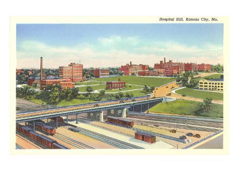
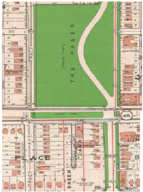
“Postcard of Hospital Hill showing the green space of City Hospital Park, Missouri Valley Special Collections”

Although intended to serve as public space at the city-funded hospital campus, declining race relations and political corruption fueled a tense segregation between the two hospitals that led to led to decreased utilization of the space. While Kessler began the planning and design of nearby Washington Square Park, hospital administrators transferred the park along with surrounding parcels of land to the Kansas City Board of Parks Commissioners. Kessler than had the authority needed to design a more functional park space and connect it to the boulevard system via Gillham Rd.

Existing Conditions

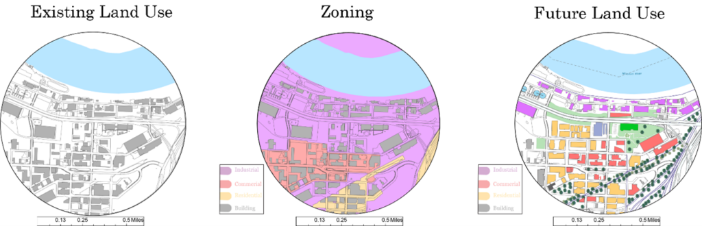
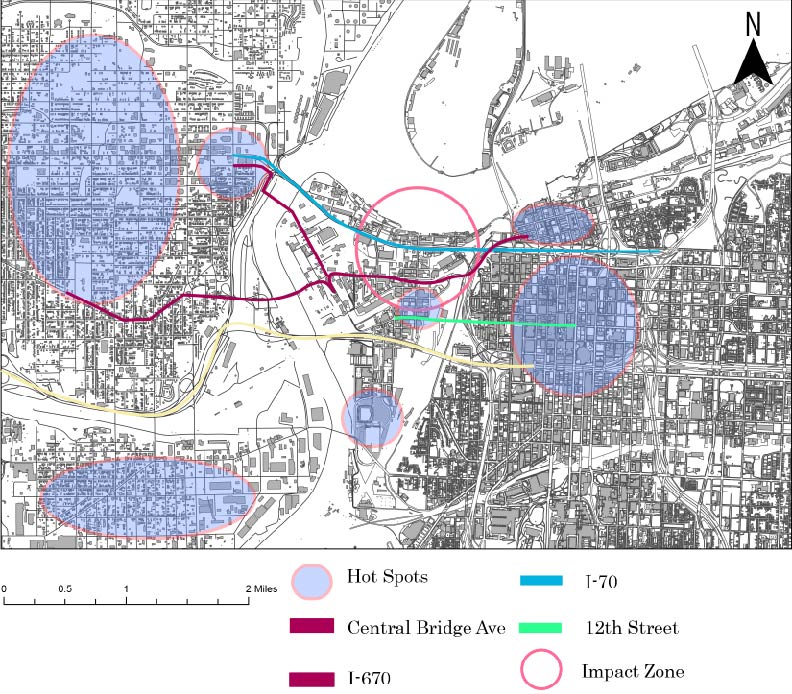
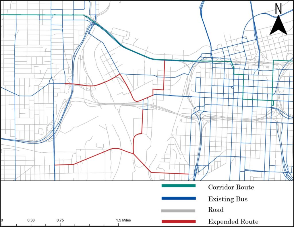
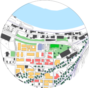
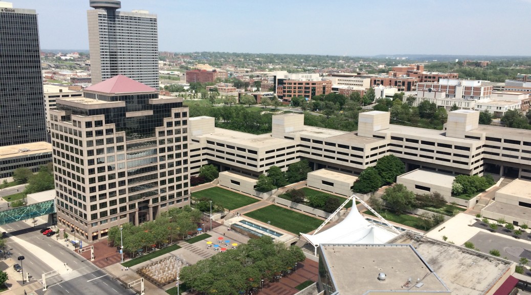
Kessler’s efforts at transforming the racially segregated buffer space of the former park was successful in 1942 as the newly designed park was christened with a new name, Hospital Hill Park. With the changing framework of hospital ownership and administration, the name captured the changing character of the area as multiple hospitals and educational institutions located around the former General Hospital campus. Despite overcoming the initial barriers of the former park, Hospital Hill Park faced a new set of challenges that would become further antagonized by the parks urban location and changing built environment. With large scale development occurring at Hospital Hill, Hospital Hill Park’s boundaries began to be pushed to the corner of 22nd St and Gillham Road and threatened with encroachment from nearby Children’s Mercy Hospital, which expanded to the park’s southern and eastern boundaries. At the close of the 1960’s, Donald Hall and executives from the Hallmark Cards Company identified the blighted commercial areas just west of Hospital Hill as the new location for their master planned corporate headquarters. Envisioned as a new ‘’uptown’’ retail and corporate center for Kansas City similar in nature to the Country Club Plaza, the new development of the planned ‘’Crown Center’’ development began to change the composure of Hospital Parks remaining untouched borders. Despite the park’s once strong connection to the rest of the boulevard system in Kansas City via Gillham Road, development from Crown Center dramatically altered the terrain and intensified the elevation difference between the park and neighboring development. Today, the current boundaries of Hospital Hill Park have been pushed to the limits, neighbored not just by development, but large-scale super block expansion at Children’s Mercy Hospital and Crown Center that has overlooked adequate connections to the park. Now diseccted by Gillham Road which experiences much higher levels of traffic than Kessler anticipated, the park sits isolated in an area of the city that has some of the highest density of potential users. In the census tracts making up the Hospital Hill and Crown Center Districts, there are nearly 23,000 employees. Of these employees, only 233, or 1%, live within the area’s census tracts. Additionally, of the remaining 99%, nearly 17,000 commute more than 10 miles from the offices and hospitals in the Crown Center District. In areas where there is a high concentration of commuters and employees, parks and public space play an especially important role in providing organic and accessible space to people outside of their homes.

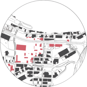
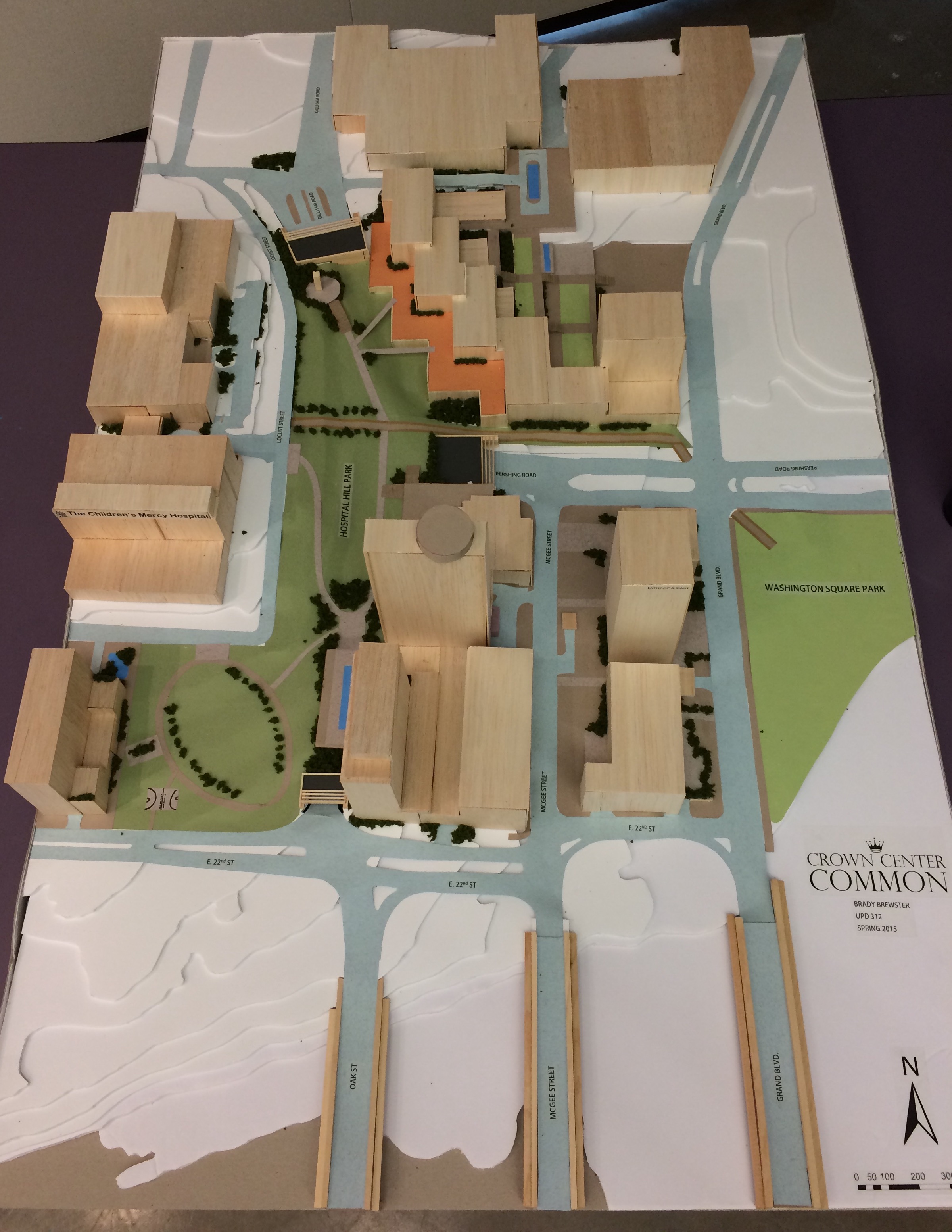
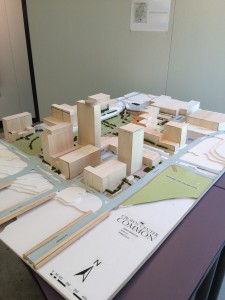
Crown Center Common, the 21st Century Design of Hospital Hill Park

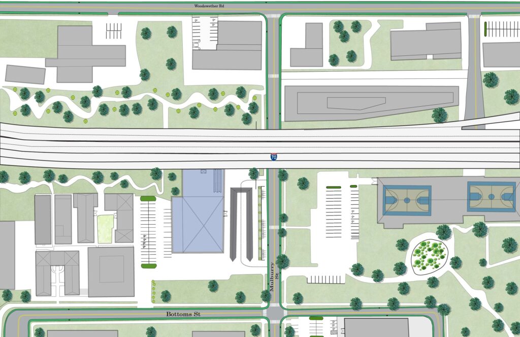
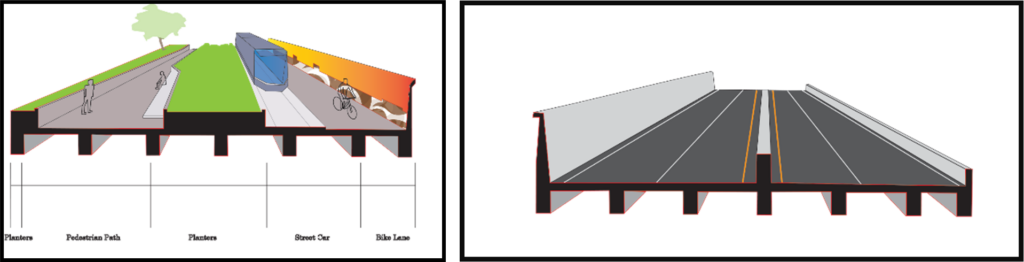
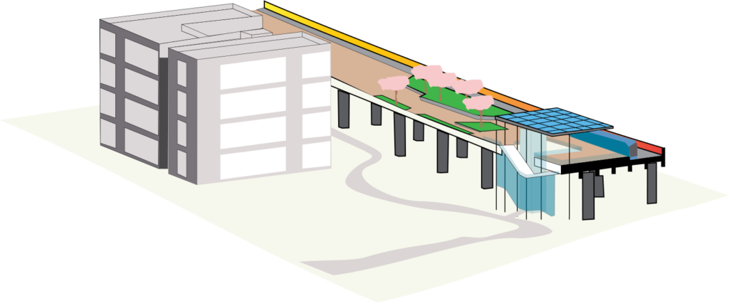
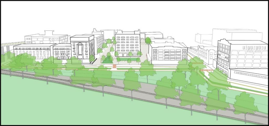
To address the current challenges to the park after 75 years of being overlooked and inadequately connected to its surrounding urban fabric, I envisioned an ambitious connection plan with Hospital Hill Park at the focal point. Taking note of the historical boundaries of the park, the plan calls for the addition of former park board land that has been marooned by the multiple traffic lanes of Gillham Road and Pershing Road. By sinking the existing traffic thoroughfares into a cut-and-cover tunnel, park space can be built above over the sunken roadway and expand the boundaries of the park from the edge of Children’s Mercy Hospital directly to the edge of hotel and office space at Crown Center. Removal of the roadway will also allow terraforming in certain areas of the park to create a more manageable pedestrian and bike connection between the two districts. A newly created bikeway winds through the organic park space to provide a new park amenity and further connect the park to the surrounding areas. By adjusting the elevation at which park meets built environment, existing development in Crown Center has the opportunity to connect into the park which is envisioned through the construction of a retail promenade at the Pershing Road Office complex.

IMG_7583

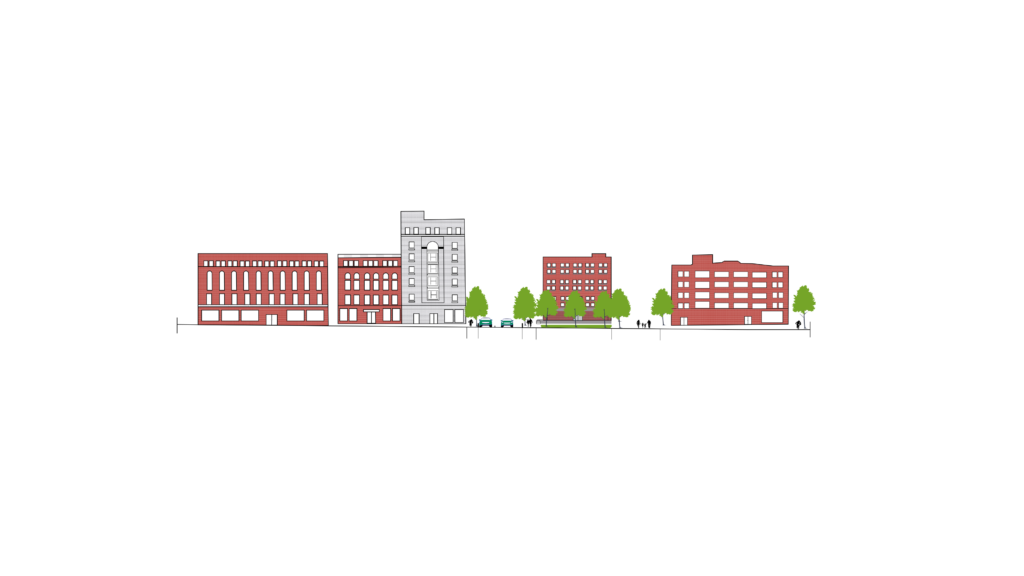
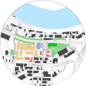
Unconstricted by the former roadway that paralleled the ground level of office space, the new park could meet at the various levels at which the Pershing Complex connects with Crown Center Square. Repurposed space from office to retail could be sustained through the direct access to Crown Center Shops and Square and the large parking structures that are submerged beneath the office complex. Additionally, the existing hotel that would border that park in this design, the Crown Center Sheraton, could bridge into the park by construction of a new outdoor plaza and lagoon, further increasing the park as an area amenity and increasing utilization of the park. New development at the site would be in response to the high level of commuting employees in the area. Two new residential mixed-use towers would be constructed to house more of the areas employees and increase activity and eyes on the park, benefitting the park in terms of both use and safety. Office space on the ground floor of the towers could accommodate commercial office or institutional use currently demanded by Crown Center institutions.

IMG_7577

Overall, the new vision of Hospital Hill Park would address the inattentive development that occurred around the park and reconnect the space into the Hospital Hill and Crown Center Districts. New connections would support a revitalization of existing developed space and propose an opportunity for the emergence of a new phase of residential and commercial development in an area sometimes thought of at build out. Such a second phase of Crown Center and the institutions at Hospital Hill could be supported by major stakeholders such as the Crown Center Redevelopment Corporation, Children’s Mercy Hospital, Truman Hospital, UMKC, and the various insurance companies that house their Kansas City operations in Crown Center. With a vested interest in the success of public spaces and the opportunity for catalyst potential, these influential stakeholders will play an important role in the reimagining of Hospital Park and its transformation into a 21st century park of Kansas City.