Long regarded as the ‘Paris of the Plains’, Kansas City, Missouri’s storied fountains and ornamented boulevards capture some of the elegance made famous by our European counterpart. Despite the acclaim our city receives for the beloved parks and boulevards system, such ambiance hasn’t always been the benchmark in Kansas City. Riddled with the grime and lewd behavior associated with the stockyard industry, one who found themselves in Kansas City before the turn of the century would see a much more savage environment than that of which our parks evoke today.
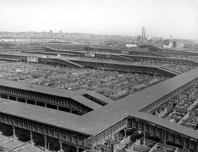
Kansas City, Missouri Livestock Auction: Although amassing great wealth for the region, the industry was unsightly and riddled the city with transients and crime at the turn of the century. Source: Missouri Valley Special Collections
The reincarnation of our city can be attributed not from the wealth or power of the stockyards but is the work of one man: George Kessler. Kansas City’s first landscape architect, Kessler was a jack of many trades and titles. Architect, planner, civic leader, and even lobbyist, Kessler’s early triumphs include petitioning Missouri state law to establish a city parks board and begin the issuance of municipal park bonds. Armed with the bureaucratic power and funding necessary to carry out his aesthetic desires, Kessler designed a parks and boulevards system for the city that came to consist of 2,668 acres of parks, 90 miles of landscaped city boulevards, and 38 miles of manicured park boulevards. The planning and construction of the park’s system faced an uphill battle at the time of conception, but eventually came to be beloved by citizens and envied by the rest of the nation. Today, however, Kansas City’s parks system face an entirely new set of challenges. Problems aided by decades of population decline and further fueled by the urban issues of the 21st century American city.
West facing view at 12th and Paseo Blvd. Many of the neighborhoods surrounding Kessler’s boulevards are tormented by issues of crime and depopulation. Source: Photo by Brady Brewster
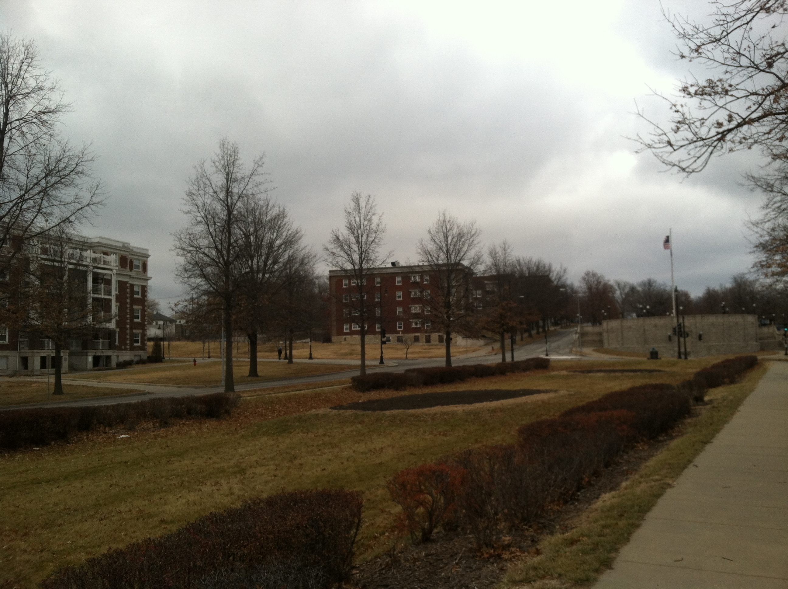
Almost 120 years after completion of Kessler’s plan, the dynamics of our city has changed. Although the parks are still beloved, many citizens today choose to enjoy the parks system through the lens of their automobile rather than from personal experiences within the spaces. As population and housing demographics have changed, the effect on Kansas City’s parks and boulevards has been devastating. Many of the historic parks are now found in areas perceived as crime-ridden and impoverished. Combined with population loss of the central city of Kansas City, Missouri, the vibrancy of the urban core is much different from when Kessler set his jewels of parks in the boulevard-laced necklace of the city. Despite issues of increased automobile usage and poor utilization by residents of the city proper, Kansas Citians still champion the legacy of Kessler’s parks and call for the creation of more. Through straightforward observation, the lack of users in our parks is clear. Even in an automobile-entranced city such as Kansas City, is it really the case that users don’t want to leave their car to enjoy a system so greatly praised and useable?
Budd Park in Northeast Kansas City: Devoid of users despite it’s setting in a dense neighborhood near multiple schools.
Source: Photo by Brady Brewster
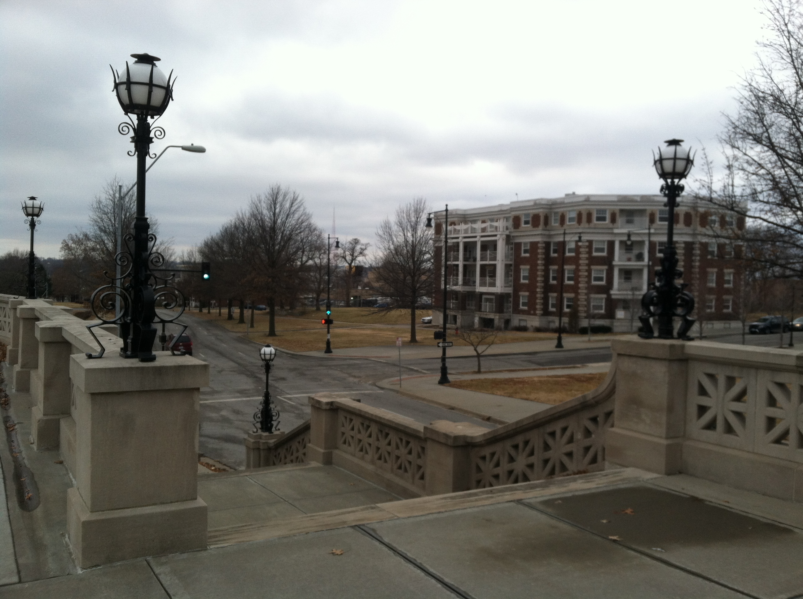
Paradoxically, two parks from Kessler’s original plan have seen a degree of developmental resurgence in the areas surrounding the parks rather than decline. Washington Square Park and Hospital Hill Park lie separated by the large scale master planned development of the Crown Center District. Union Station restricts the western boundary at Washington Square Park and the eastern boundary by Hospital Hill Park has developed into the sprawling complex of the Hospital and Academic institutions on the hill. In the changed dynamic of neighborhoods and park users in 2015 Kansas City, one wonders why even these parks lie empty at peak times of the day. With thousands of white collar and healthcare workers surrounding both parks which capture pristine views of the Kansas City skyline within just steps of their workplaces, such behavior speaks to utilization issue of Kansas City’s parks. Perhaps less people use the parks today not because they are bound to their auto or because they view the parks as dangerous but for other reasons. Looking more closely at Washington Square and Hospital Hill Parks, the issue is not with the density of residents or workers within walking distance to the parks but rather a problem of isolation and connections. A lack of accessibility via parking is especially evident at Hospital Hill Park. Combined with increased vehicular traffic in the area and lack of pedestrian connections, portions of the park that were once lively green space are now destined to mere median space dissecting two directions of traffic on Gillham Ave. Washington Square Park has the opportunity to be a showcase park for the Crossroads neighborhood, but poor connections to the street and office skyscrapers of Crown Center render the park isolated from the surrounding fabric of the area. The Link, a man made skywalk system meant for the sole purpose of connecting the Crown Center Complex to the surrounding areas, actually functions in a reverse role, creating a barrier between the park and Main St. Once served by historic streetcar lines, the reintroduction of rail to Main St. parallel to Washington Square Park will be an interesting study as to how model rail transit influences the park. In further study of Kessler’s parks and boulevards systems, I would like to examine how connections: transit, vehicular, and pedestrian influence utilization at the parks and what type of intervention needs to take place to restore these park’s to former glory. In greater focus, I would like to further explore how large scale development such as the Crown Center and Children’s Mercy Hospital developments have negatively impacted the park by neglecting such connections…..
Washington Square Park lies at the heart of a highly dense and developed mix of office, retail, and residential yet lies empty for most of the day. Connections such as The Link (pictured), lack of vehicular parking and pedestrian connections that are oddly placed relating to the surrounding fabric of the area may play a role…
As you’ll read in other posts here, several of us in this studio are natives or long-time residents of the Kansas City area. So, like for them, these aren’t exactly my first impressions of the Parks and Boulevards. Instead, they’re impressions based on two decades of living here and experiencing – or, as you’ll read below not experiencing, in a sense – the system.
Several things are important to point out about the Parks and Boulevards system, especially from the perspective of native: first, there’s a myth and a separate reality about the system; second, besides this cognitive disconnect, Kansas Citians seem physically disconnected with much of the system — a lot, if not most, of it doesn’t get used, as you’ll read below. The system exists as a type urban legend to many Kansas City — we’re largely unaware of all it has to offer.
We get to take on that challenge this semester and work to reconnect the city to one of its best features.
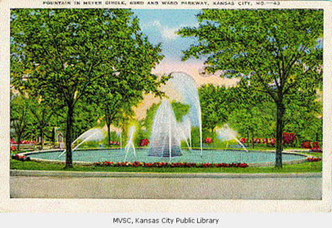
Kansas City’s Parks and Boulevards system was the stuff of postcards. “Fountain in Meyer Circle.” Source: Missouri Valley Special Collections. Date: Unknown, possible from the 1920’s.
The Myth
The Parks and Boulevards system is part of the shared experience of Kansas Citians. It’s an urban legend, in the sense that it’s passed on through the common spoken narrative, like creation stories and myths are shared across thousands of years among members of cultures around the world. We understand as young Kansas Citians that our Parks and Boulevards are something special – or at least are supposed to be. New York has its Central Park, St. Louis, Forest Park; but Kansas City is special because we have gems like Loose Park, Swope Park, and so on, which by themselves don’t quite offer the experience of Central Park, but when connected mentally as part of a system, a city-encompassing unit… well, that’s special.
Kansas Citians are also impressed by old things. (To be clear, we are not good at preserving them – and maybe it’s the resulting relative lack of historic structures that causes us to be taken when we do discover that some structure dates back to the early 1900’s.) The Parks and Boulevards System is an old thing. This plays into the allure of the legend.
But do Kansas Citians really understand the system? Myths, after all, are used to explain the poorly understood – do we know the facts?
If you were to ask residents, “What is the Parks and Boulevards System?” most would probably answer with the better-used parts of the system: Ward Parkway, Gillham Park, Paseo, Swope Park. There will be confusion: “Hold on, is Mill Creek Park a part of it? What about Broadway – it’s a boulevard, technically? And are there parks or boulevards north of the river…?” (The answers, by the way, are yes to all.)
They might just list off all the parks and boulevards they can think of – which would almost, but not quite, be correct.
Some people – long-time residents, more likely – might be able to add a bit of historical context, having possible read the small collection of written work on our fabled system. (Remember, we like old things. And we have a good public library system.)
Others, meanwhile, would describe the Parks and Boulevards as a historical artifact – as dead, archaeological, in the past. Which is too bad.
The point is, Kansas Citians, myself included, really don’t understand one of the most distinctive features of the city’s physical environment. Which is too bad.
Reality
So what are the facts, and what’s just myth?
A lot of it’s true, actually.
First of all, the Parks and Boulevards System is indeed old. It dates back to the 1890’s, when KC was about 40 years old and its city limits extended to just 47th Street.
And Kansas City’s Parks and Boulevards System is, in fact, pretty special – there’s some truth to this part of the legend. It was designed by a German-American landscape architect/planner, George Kessler, who would go on to become a leading name in planning and would significantly shape at least a dozen other cities with similar plans. His designs for Kansas City, though, were maybe most significant and most distinctive of all his work.
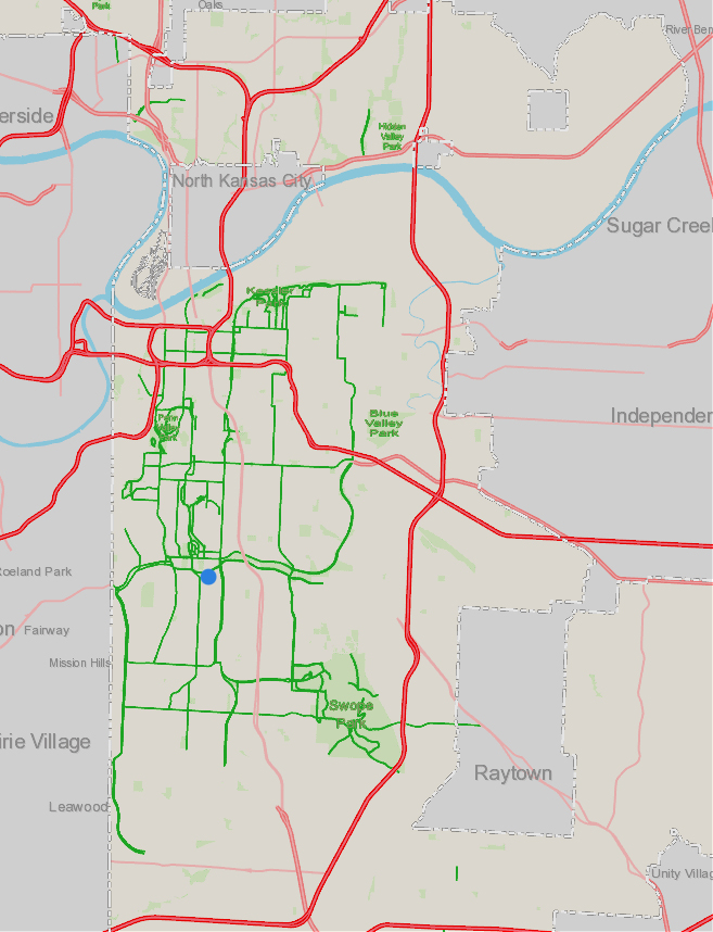
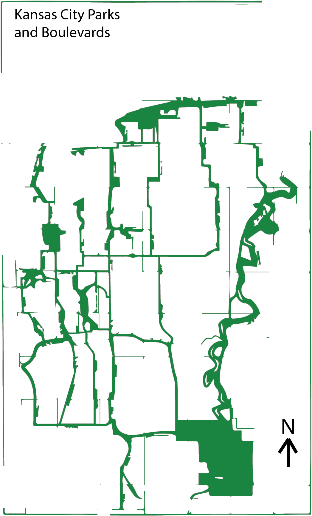
The Parks and Boulevards system, meanwhile, isn’t just a historical relic. In fact, the system is probably at its most extensive ever, especially with new parts of the system being added to the growing Northland. In the map below, the green is elements of the today’s system – which today include parks and boulevards, as well as parkways and roads, such as Ward Parkway and Rockhill Rd, that have been weaved into the system despite not being designated on maps as “boulevards.”
The extensiveness apparent in the map below shows that Kansas Citians are pretty much guaranteed, as long as they leave the house, to experience some part of the system on a daily basis. In fact, I can’t image a commute through the city (excluding those on highways) that involve at least crossing some boulevard or passing a park.
So in addition to still being in existence, Kansas City’s Parks and Boulevards System is also very much a part of our lives.
What’s in green is a park or boulevard. Source: KCMO Parcel Viewer.
But are we aware of that, as we take a drive through town? And that leads to a bigger question: I’ve said that the P&B system is at its greatest physical extent – but can we really say unequivocally that it’s at its height in a cultural sense? Do Kansas Citians embrace and (consciously) engage with their mythical Parks and Boulevards?
Alive and Well?
So, the system is alive – at least in the sense it continues to be maintained and expanded, and ostensibly, used. Whether it’s “alive and well,” is debatable, though.
By saying locals use the Parks and Boulevards, what we’re really saying is that people use the Boulevards, and not so much the parks. Sure during certain times of day, Loose and Mill Creek Parks get traffic. (Both are avoided after dark, despite being very centrally located, due to almost zero lighting.) People go to Swope for the zoo and Starlight Theatre. Maybe some disc golf.
The city’s parks are by no means unused; but at the same time, for the thousands of acres of parks that exist and that are maintained (which implies that somebody expects them to be used), KC’s parks seem to receive a smattering of traffic. (And remember, these aren’t exactly my first impressions – I’ve noticed this for about two decades living here.)
Brush Creek and Parks
Take Brush Creek Park – or as the city’s local Parks and Rec department calls it, “Brush Creek Greenway Park”. Anyway, it follows the flow of Brush Creek from Brookside Boulevard in the west to almost where the creek meets the Blue River (the “Big” one).
For non-natives of KC, let me just say this park is an incredible improvement over what used to be there. Transcendental. Since the days of boss Pendergast in the 1930’s, Brush Creek had been covered in concrete — with only a tiny rivulet of water in the middle visible — in an effort to control flooding.
The whole length of it.
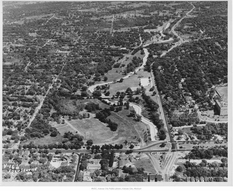
This is what that looked like going through the Plaza in the 1970’s, when the so-called flood-control solution failed, actually exacerbating floods that killed a few people nearby:
Source: Missouri Valley Special Collections, 1970’s
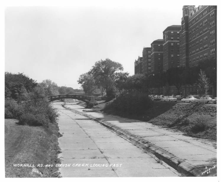
And to underscore how much creek the concrete covered, here’s a photo of the covered creek, looking east from 47th and Paseo, about a mile east of the above photo:
Source: Missouri Valley Special Collections. 1955.
It’s thought that those deaths got the gears of government grinding, and a revamp of the creek, directed by the US Army Corps of Engineers, was soon drawn up, and it began to be implemented in the ‘80s. Concrete was employed again, but this time it was used to build cascades, paths, and new bridges along the now “daylighted” creek (that’s the urban planning term for uncovering a body of water).
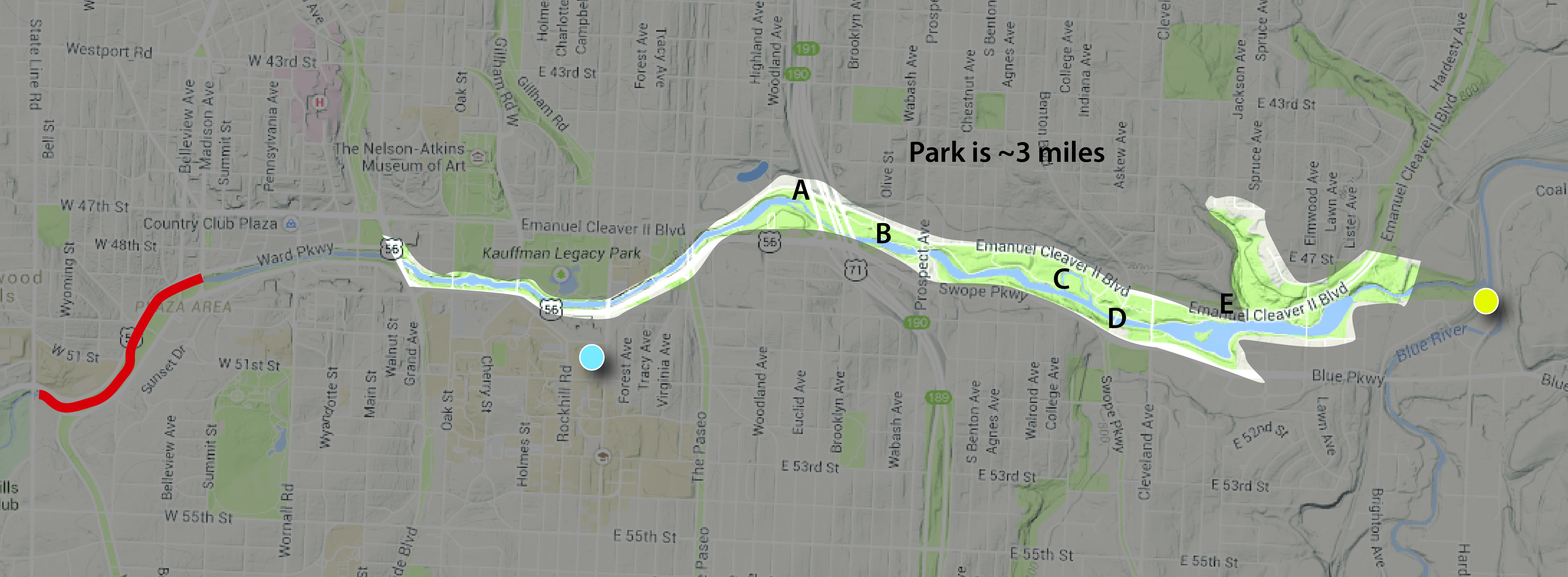
The park is highlighted. The yellow dot is the confluence of the creek with the Blue River. The blue is Katz Hall, home to fine members of UMKC Urban Planning + Design. The red is the portion of the creek that has yet to be “daylighted”. The letters correspond to photos below.
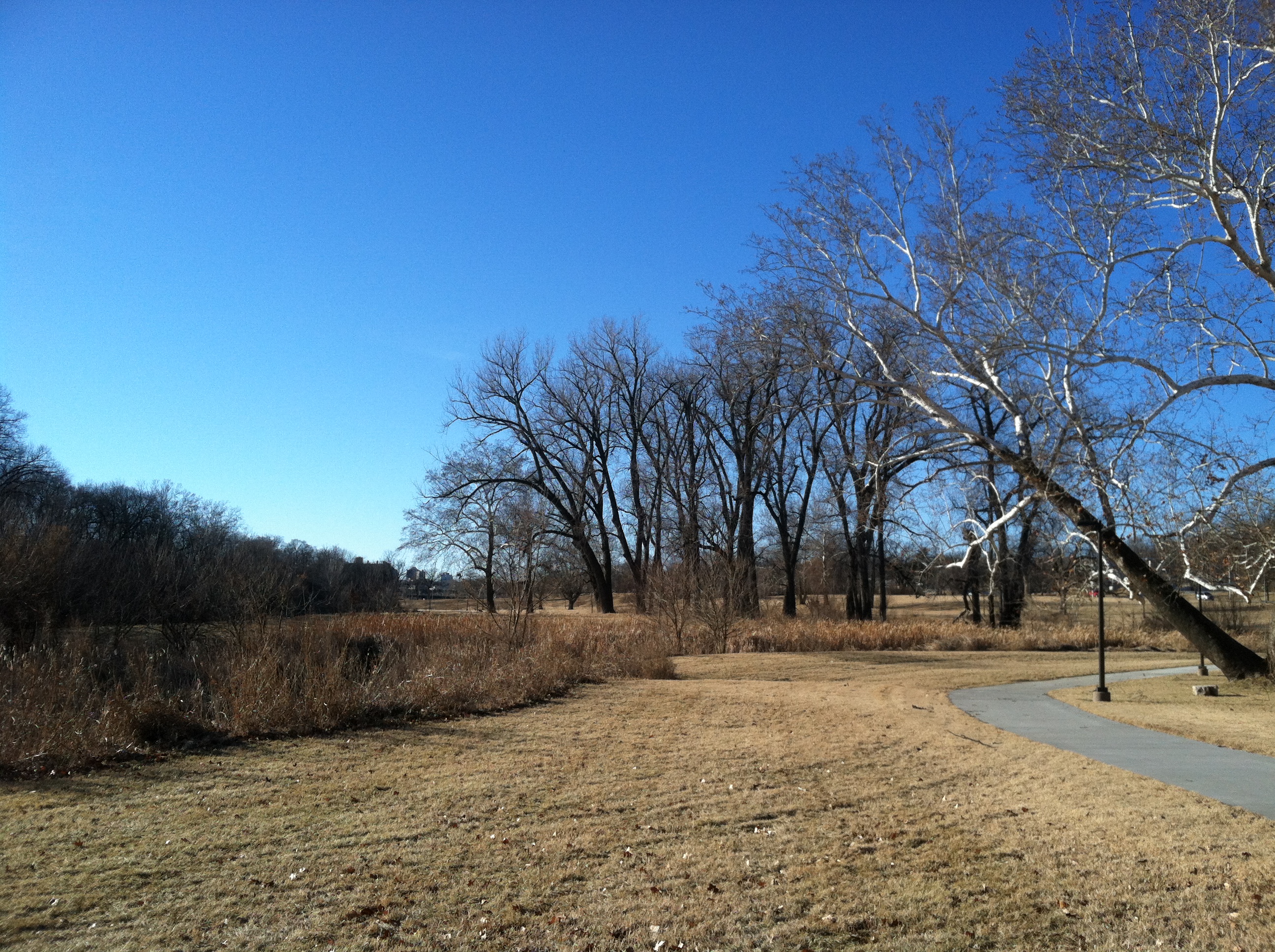
The Brush Creek Greenway Park encompasses, maybe, 9/10 of the improved creek. (Almost mile of the creek, between State Line Rd and the Plaza, is still covered in ‘30s concrete. It’s in red on the map. There’s another part of the creek through the Plaza that is not a part of the park.) Considering that, it’s a big park – about 3 miles long. And within those 3 miles is about 250 acres of open space – “park.” That’s a little misleading, too, because the Greenway Park runs through several other substantial parks – such as Theis Park – that aren’t counted towards that total.
Judged as a park – separate from its context – Brush Creek Greenway Park is a great park. You get basically three miles of uninterrupted trail along a decently scenic (ignoring the odd swirl of garbage) creek. There’s a lot of open space, some nice landscaping, waterfalls, fountains, and benches. Some decent views, too.
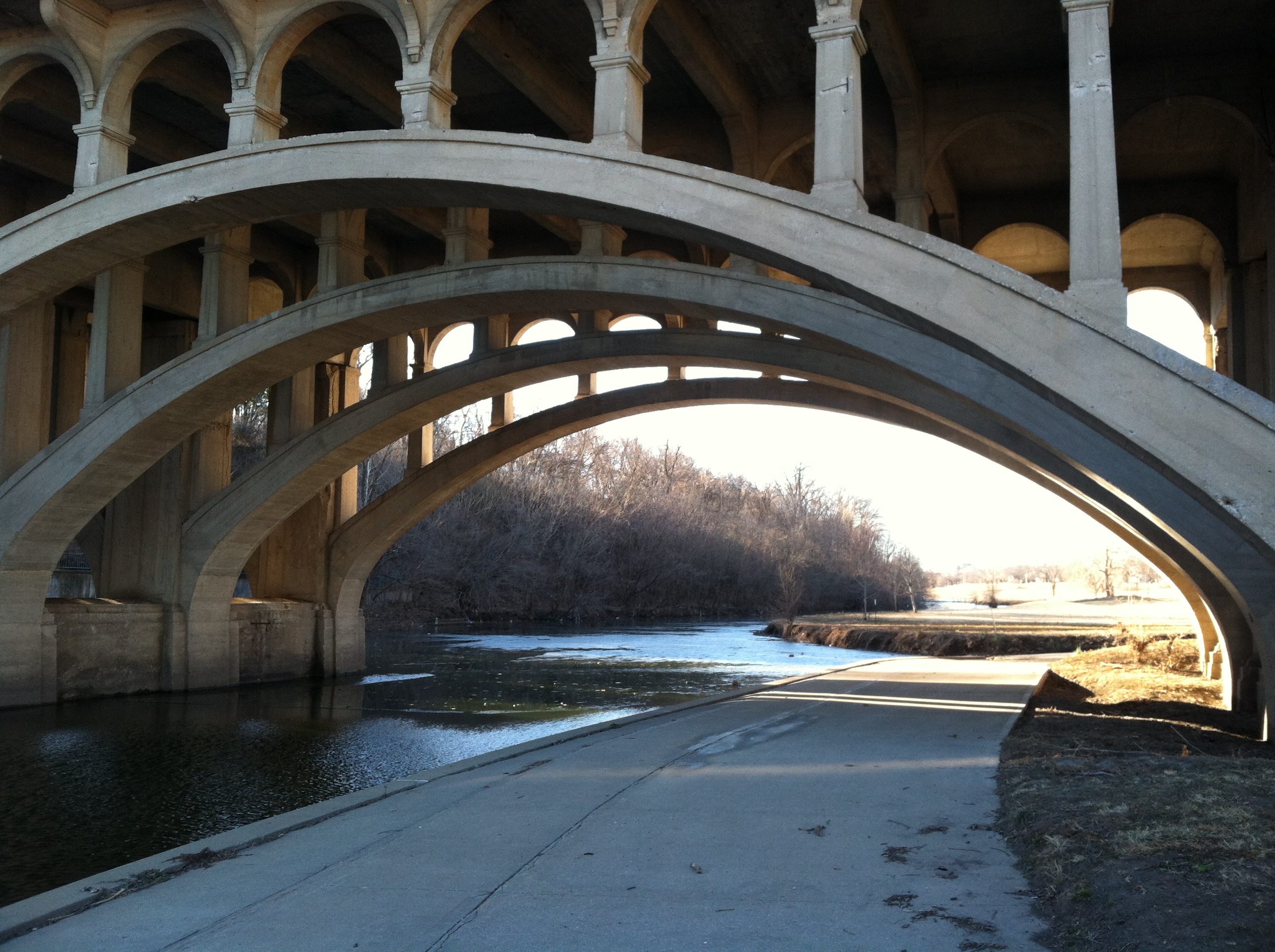
A – The park’s 3-mile trail is uninterrupted. Not even by 71 Highway.
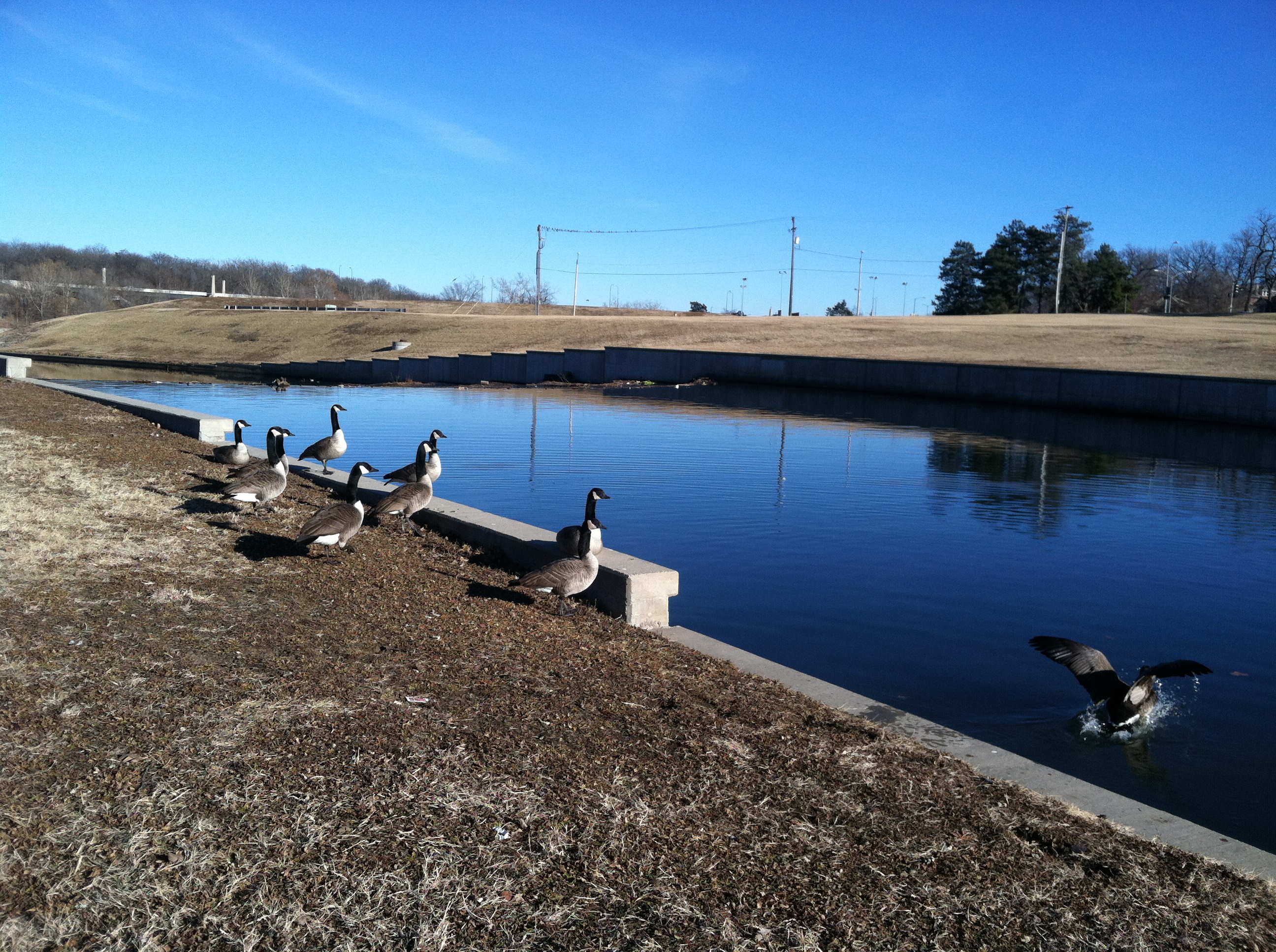
B- Plenty of visiting geese enjoy the park and views of the scenic, much-improved Brush Creek.
C – The park is very scenic. You feel like you’ve escaped the city, at times. (Actually, there’s neighborhoods on all sides here.)
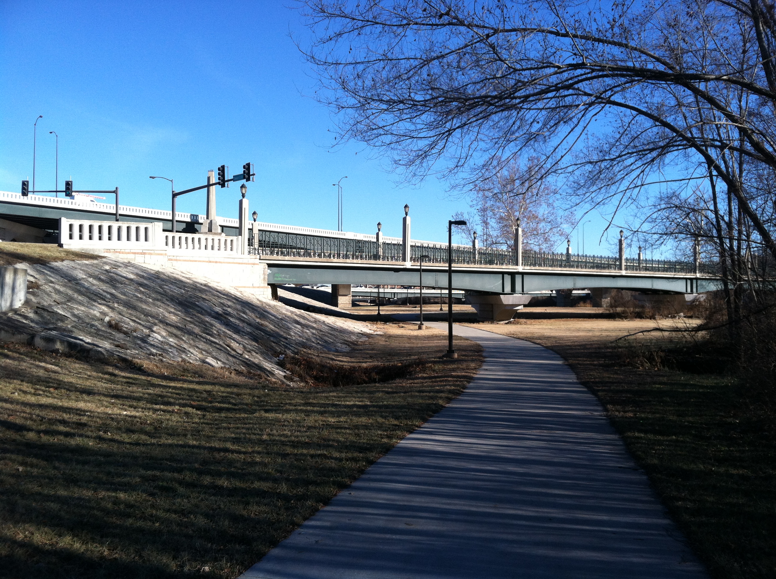
D – See? Very picturesque. This is the Benton Blvd. bridge.
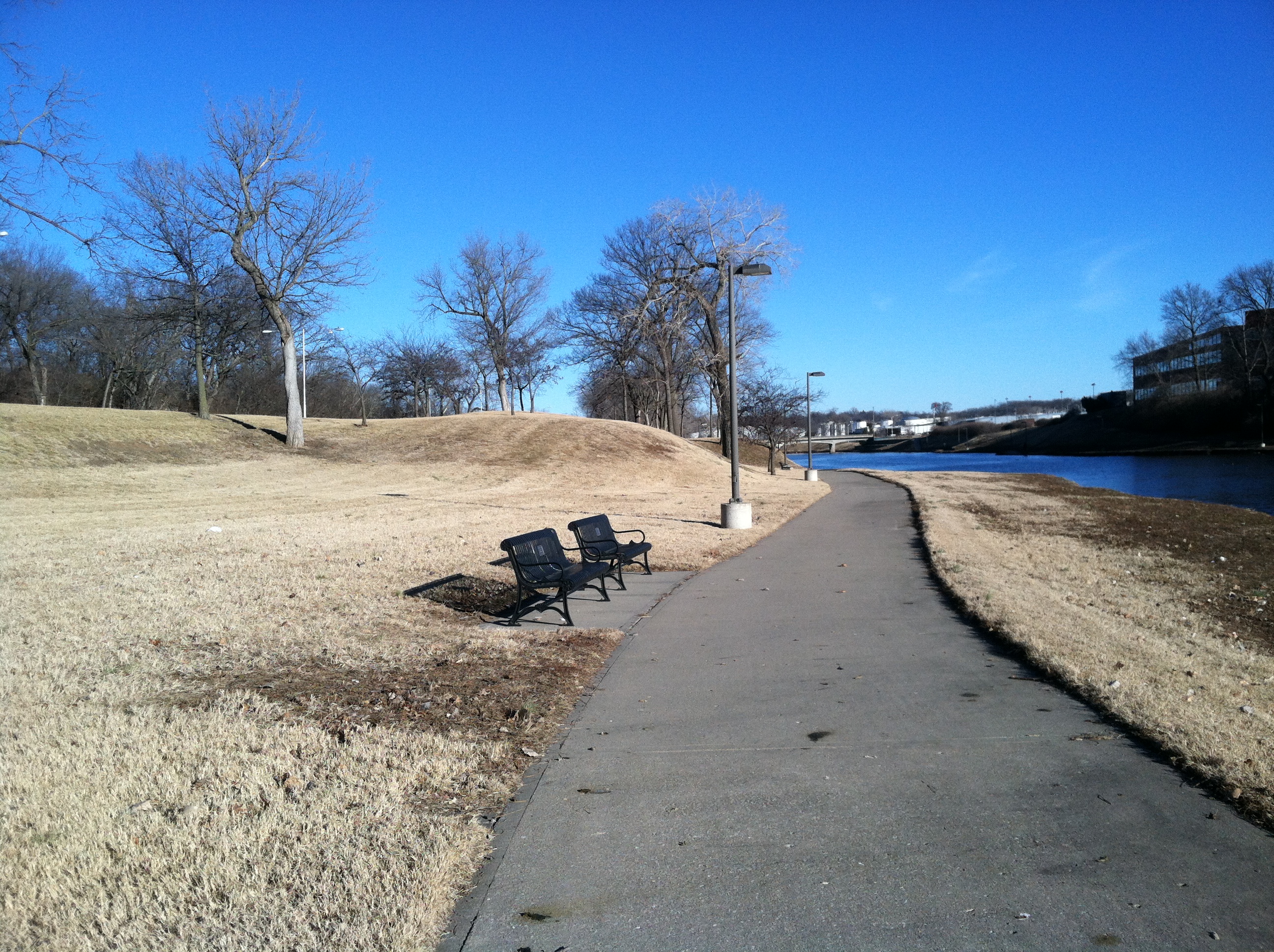
E – And there are plenty of benches, lighting. Any people, though?
But what else is the park?
It’s empty.
The other day I took a bike ride from Katz Hall (the blue dot on the map) to the end of the park, where the trail also ends. It was a 2.86-mile ride on which I basically saw all 250 acres of the park.
That afternoon, I saw five people in the park – and one was a city worker picking up trash, while another was a homeless man who appeared to be living under the Cleveland Ave bridge. So, really, there were two people using the park for recreational purposes. I rode basically the whole length of the park – out and back – and saw three park users. It was a very nice day – about 60 degrees in late January – and it was rush hour, when parks often start to get filled with people exercising/relaxing after work and kids playing after school.
Two hundred fifty acres and the recent target of, surely, tens of millions of dollars of improvements was being used by three people.
Is this representative of all Kansas City parks? No. But a lot of them, yes. Based on what we’ve recently observed, touring parks on the east and northeast sides of Kansas City, yes. Based on what I’ve observed of various parts of the Parks and Boulevards system over 20 years – even on nice days – definitely, yes.
Paseo and Boulevards
What about boulevards, though? I’ve already admitted these are well used, right? Sure. But does just driving through count as fully, consciously partaking in them? What if saying you’ve used the Paseo by driving down it was similar to saying you’ve been to the Grand Canyon because you’ve flown over it?
On one hand that seems extreme, because by driving down any boulevard, you’re obviously using it. And you’re probably enjoying the scenic view its trees and plantings offer. On the other hand, there’ s a lot more to a lot of these boulevards than most of realize — experiences most of us never have because we tend to fly through the Parks and Boulevards. Example? Paseo, near downtown.
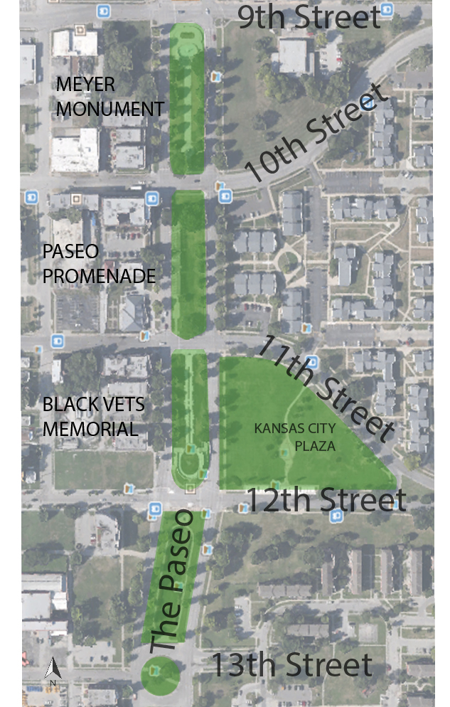
Paseo, for a good deal of of length, is more than just a tree-lined street. For several miles it has a substantial median, which works as park. On a stretch of the Paseo between 9th and 12th streets are some of the most attractive elements of the Parks and Boulevards system.
Some of the best parts of the entire Parks and Boulevards system are found in the median here. Too bad no one visits.
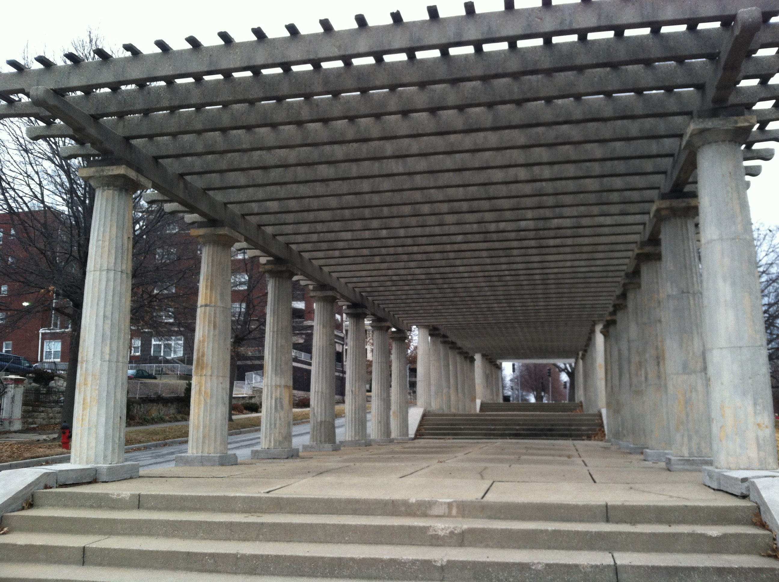
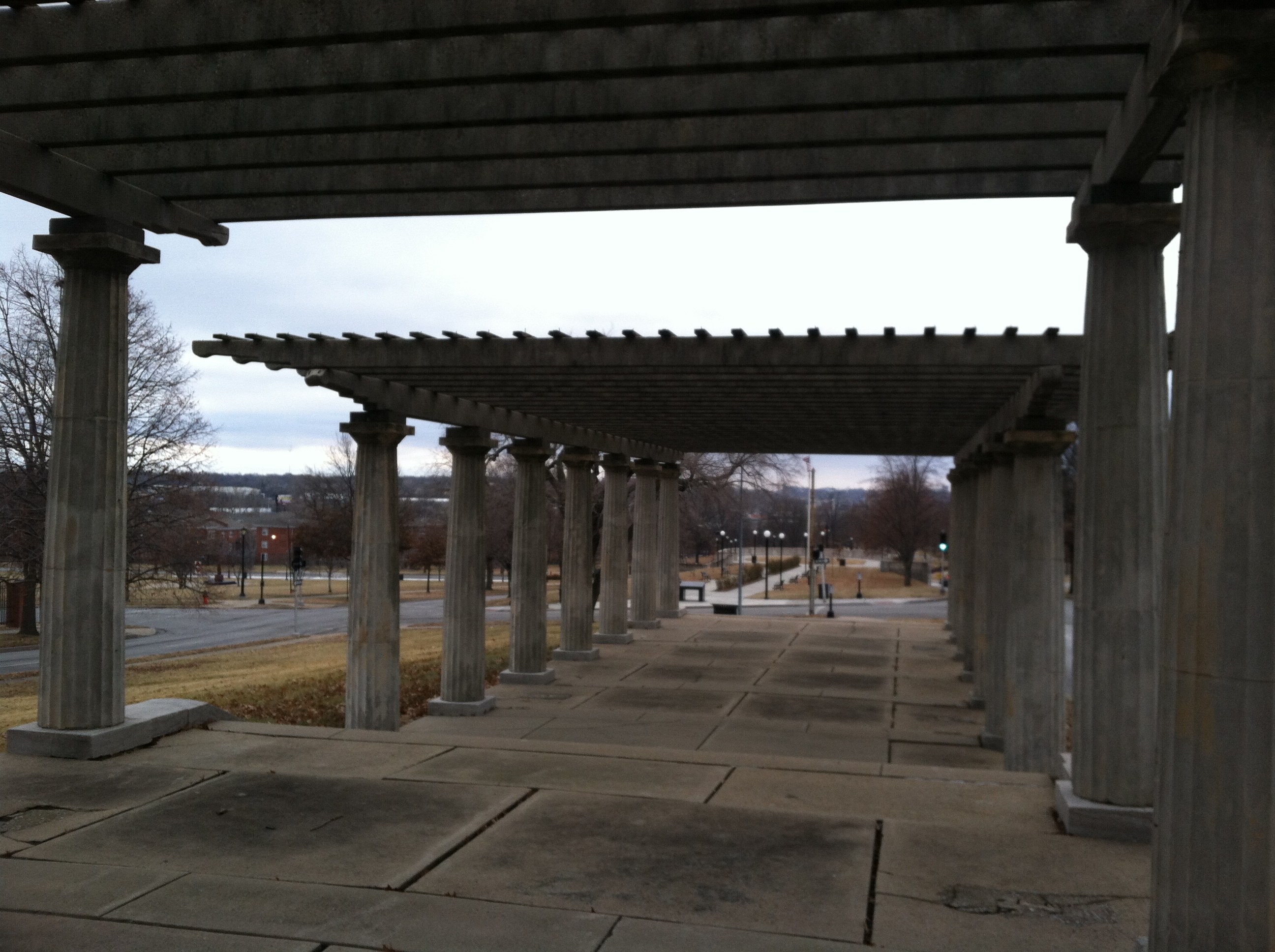
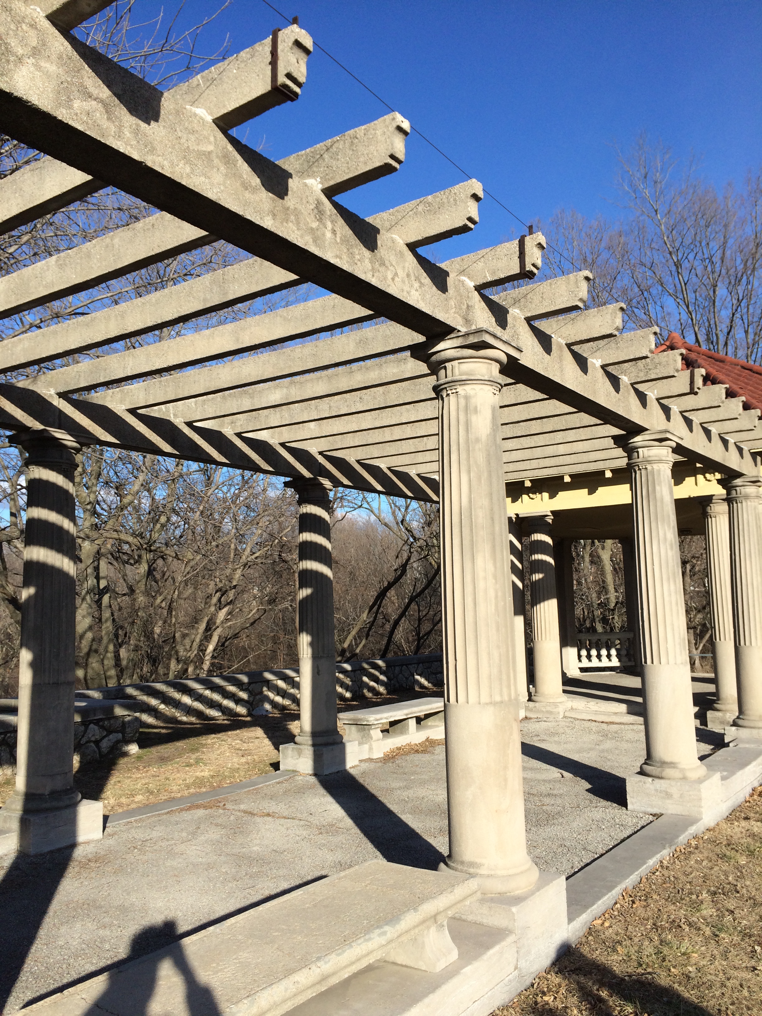
Exhibit A: The Paseo Pergola, located between 10th and 11th street.
Looking north, between 10th and 11th streets
Looking south, between 10th and 11th streets
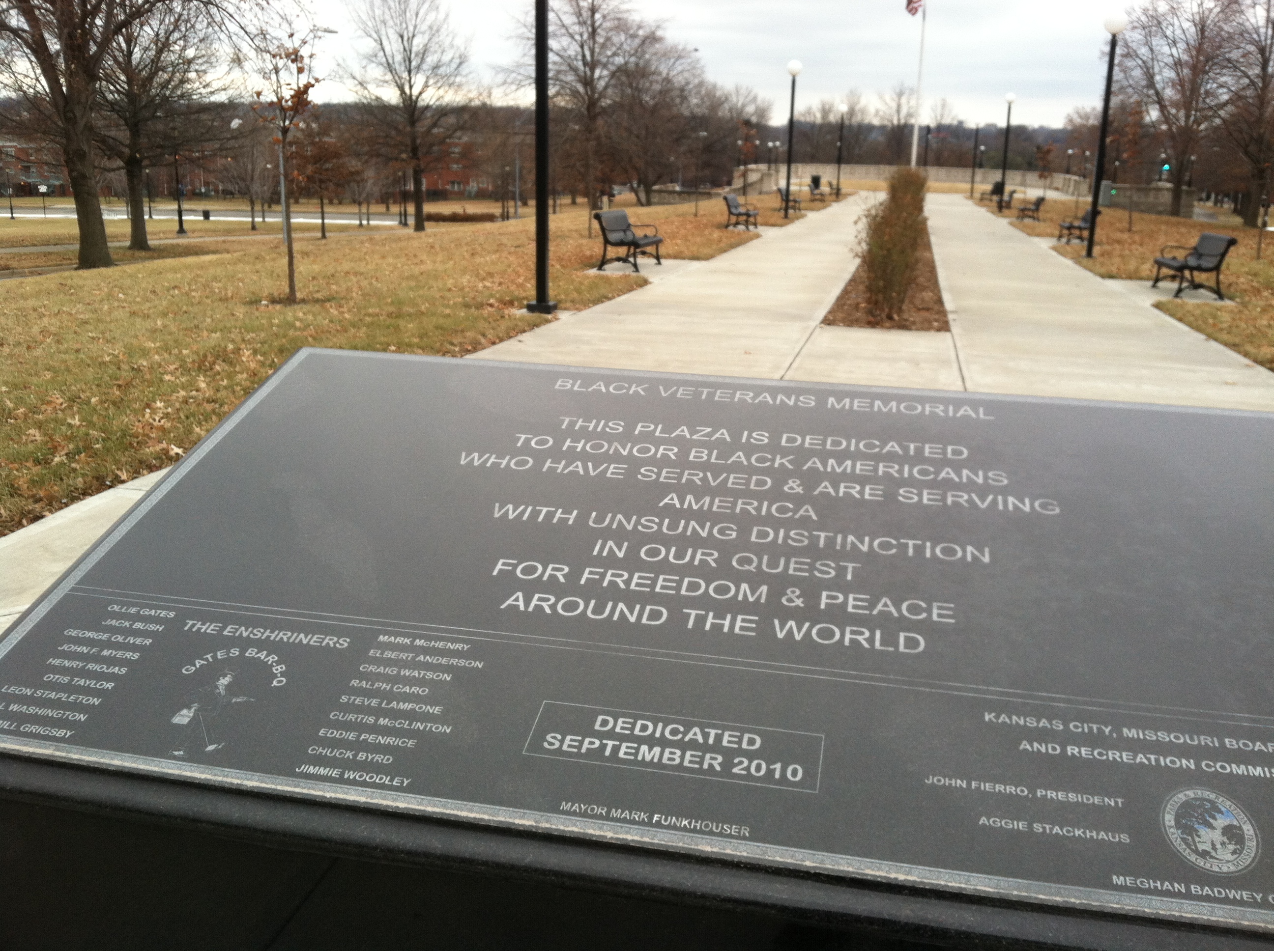
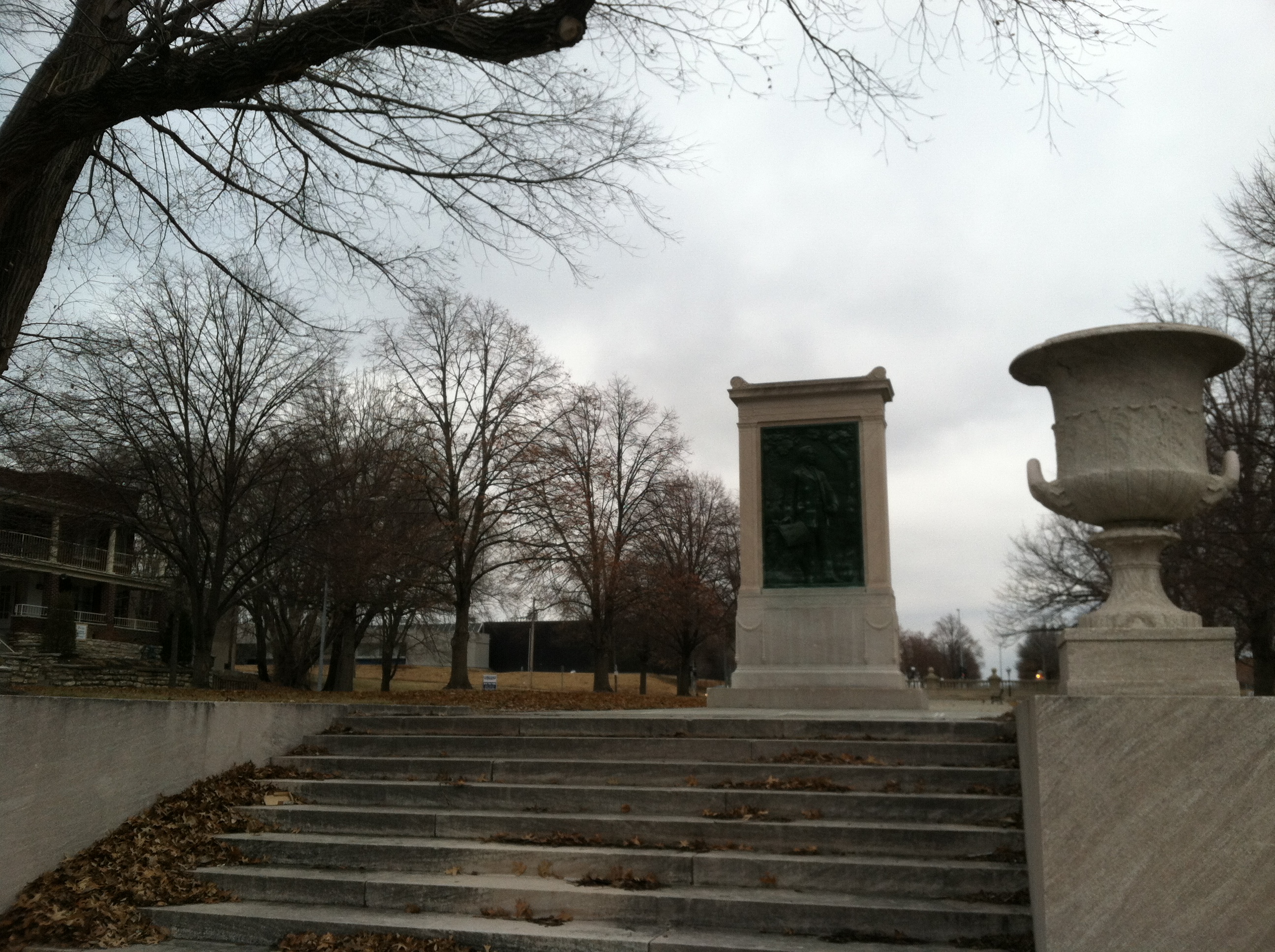
Exhibit B: The Black Veterans’ Memorial
Plaque for the memorial, north endLooking down from a “platform” at north end of the memorialLooking towards the platform from the south.
Exhibit C: August Meyer (co-designer of the Parks and Boulevards system) Monument
North end
In all, this three-block segment of the eight-mile Paseo is one of the most attractive, pedestrian-friendly, even “urban” spaces in the city.
And yet, no users were present — and I’ve rarely seen anyone there on sunny, warmer days either. There were plenty of people driving down the Paseo, but no one stopped to enter this park-like space.
Look around, though, and you might have the answer as to why no one was there: the urban fabric is in tatters. Some of photos above show apartment buildings — these once lined the entire street for about a mile. Now, they have mostly been demolished, replaced occasionally by industrial lots, incongrous and gated public housing, or just left vacant. There are no activity centers nearby, so hardly anyone’s walking along the street to begin with — those driving by are not stopping. (It’s really no different on Ward Parkway, which runs through a much “nicer” neighborhood — even there, there are no centers nearby, and people just drive by, not enjoying the amenities in the median.)
The same is the case around the Brush Creek Greenway Park. Here, though, there are mostly intact neighborhoods on both sides of the park, and attractive parkways/boulevards on either side. And yet, still no centers/destinations, other than the park itself. Plenty of people are driving by; no one’s stopping.
Going Forward
And that might point to the problem. We build new parks and beautify our old ones without giving thought to what really made them so great, what made them “work.”
The Parks and Boulevards were designed for a time when people took scenic leisure drives en masse. We don’t do that anymore. We drive to commute.
The Parks and Boulevards were designed for a time and when Kansas City had much stronger neighborhoods with well defined activity centers. We don’t quite have that anymore.
To the extent the Parks and Boulevards system was designed as an ornamental variation of an otherwise strictly functional road, it works. As a place where people relax, play, or gather, it mostly fails.
The system used to work — as you’ll see if you follow this blog throughout the semester.
But today, to say the Parks and Boulevards system works might be like saying a tree with half its limbs dead or dying is alive.
That’s the depressing part — taking stock of the the faded glory of one our city’s most distinctive, fabulous features
The exciting part is bringing back the glory, putting the epic back into the “myth.”
Illustration of the Parkways, Boulevards and Parks in Kansas City, MO
Our city was once like many other river cities of its type, dirty, pragmatic and some might even say ugly. As it expanded from the river, the gridding and subdivision of plots expanded south towards the undulating mounds of what now is Kansas City, Missouri. As man conquered new lands, there was often a manifest destiny mindset of forming our world to our whims. Yet, when George Kessler began to implement a new idea in the early 20th century, things began to change.
As a result of the City Beautiful movement, a progressive network of Parks and Boulevards was developed and constructed. These winding tree lined boulevards and parkways took full advantage of the natural topography of Kansas City. Instead of carving straight paths through the hills, the streets that Kessler help to implement curved back and forth creating a network of interlocking streets that lead the passenger through beautiful parks and vistas.
Characteristics
There are several defining characteristics that differentiate the Boulevards from Parkways. The Boulevards generally follow the gridiron of the street system whereas parkways may follow creeks or the natural topography of the city. While there are some exceptions — parts of The Paseo and Meyer – most boulevards don’t have medians in them. Parkways generally have large medians where there is space to play and back in older times, room to park. Boulevards are also very symmetrical and while parkways are sometimes symmetrical in certain areas, they are generally asymmetrical as they wind around the curves of the land.
Topography of the Parkways in the Plaza
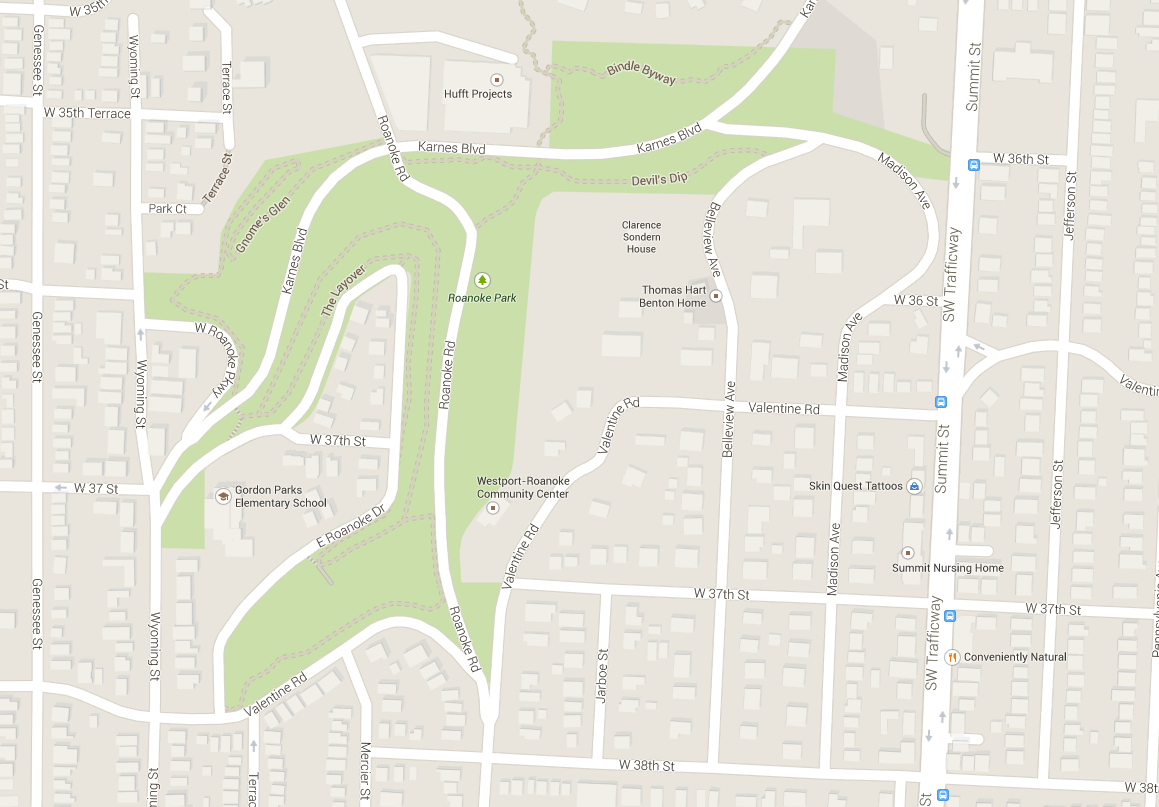
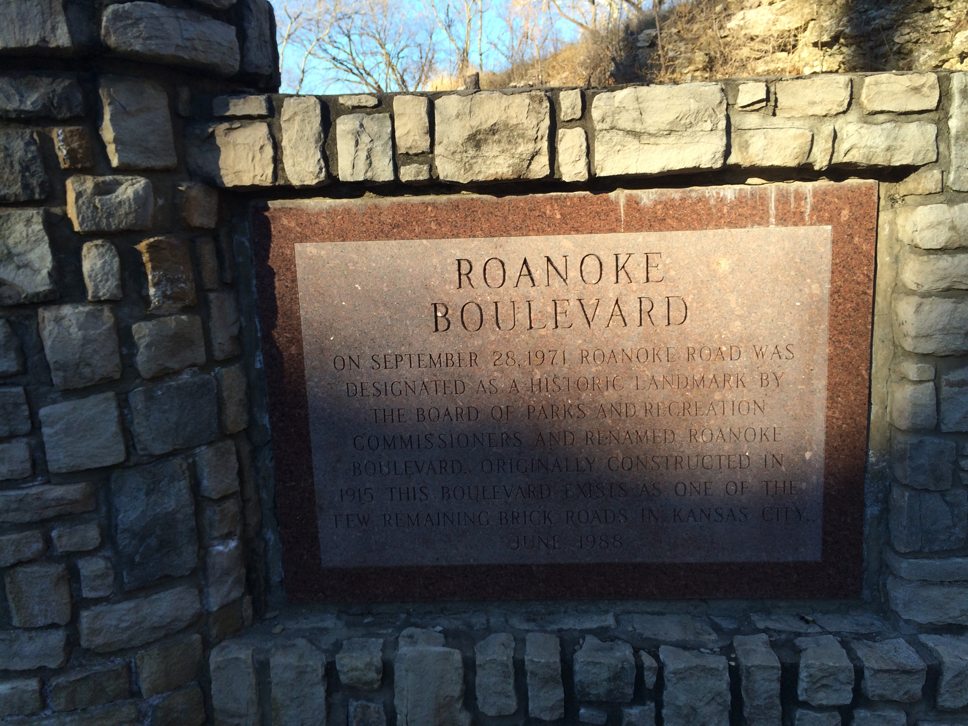
Roanoke Parkway and Park
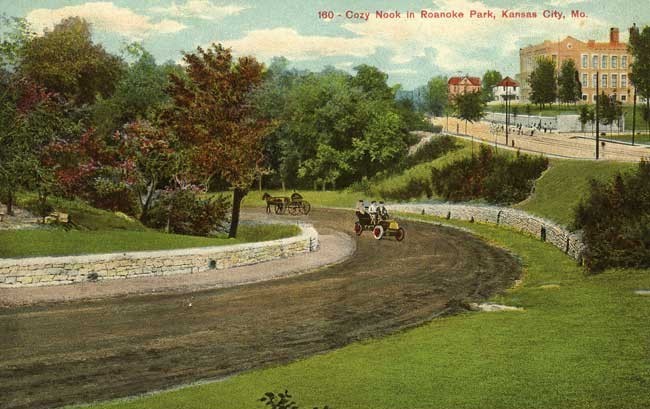
Roanoke Parkway is disparate from the Roanoke Park. The short parkway is essentially a straight road that connects Westport Road diagonally to 47th street in the Plaza. The video shows a sped up journey one would take going north-west. There are apartment buildings that line the street on either sides and the street is lined with beautiful trees and the setbacks from the street allow a wide view when traveling by foot along the road.
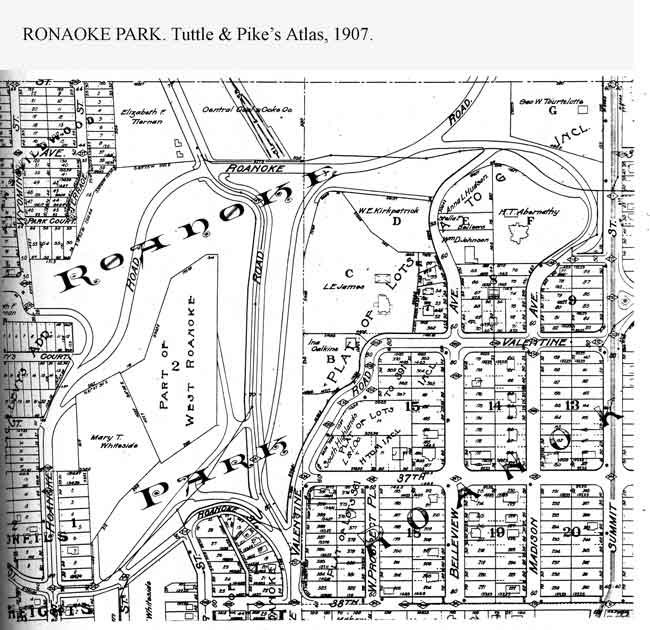
1907 Atlas Plan of Roanoke Park
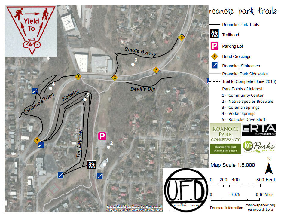
The park associated withthe Parkway is Roanoke park. Built in 1907, it is one of the oldest parks in Kansas City, Roanoke Park has an interesting shape as it tucks itself inbetween the Westport and Midtown areas.
With its beautiful trails, playgrounds, sustainable progress and a Community Center, Roanoke Park stands as a shining example of good park design. From its trails to its wide open spaces, the park offers both passive and active recreation.
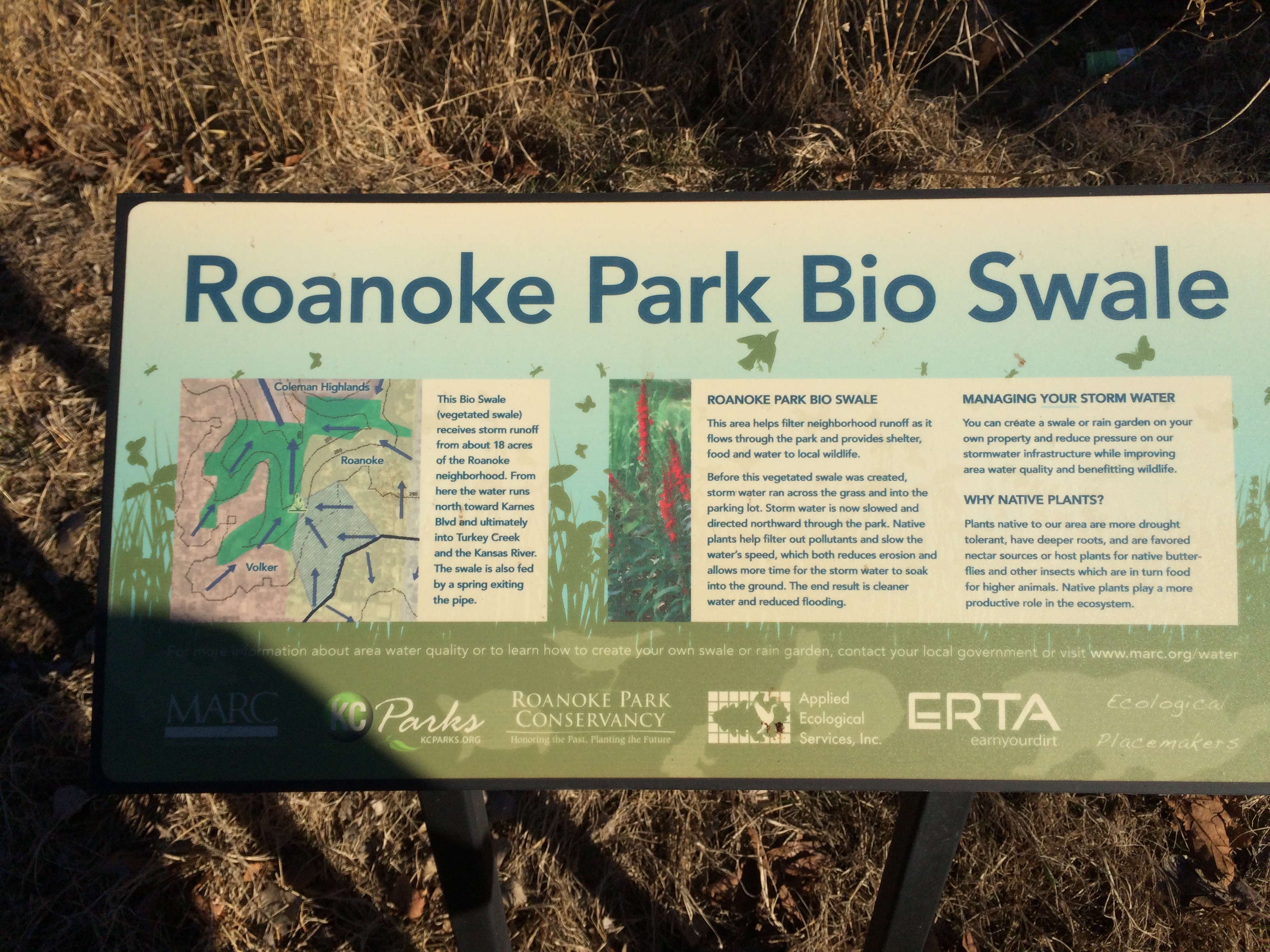
Trail MapHistory of the Boulevard
Sustainable Development
Moving Forward
I have lived in this city for 20 years and while I have never been formally taught about Kessler’s vision with the parks and boulevards, I have spent a great deal of time enjoying their beauty. As our class took an excursion to explore some of the eastern parts of the system I realized how little of the streets and park I had actually experienced. Even on a January day, there was a great attractiveness inherent in many of the parks. The Kessler Park near Cliff Drive was quite impressive, it stands as a great example of the City Beautiful movement with its Romanesque columns and its concrete pergola.
“While parks are of inestimable value in making a city inviting to desirable residents and visitors, furnishing pleasant drives to those who can afford these luxuries, adding to the value of real estate, and promoting the general prosperity, these are matters of small consideration when compared to the imperative necessity of supplying the great mass of the people with some means of recreation to relieve the unnatural surroundings in crowded cities.” – Kessler
Kessler Park Pergolas – City Beautiful Movement
The system of parks and boulevards laid a framework for Kansas City. Its good bones provide unique drives and generally pleasant experiences when getting around the city. There are areas of improvement though. How can we explore what styles Kansas City wants to represent in the future? Should we maintain the style of the City Beautiful movement or should we create our own movement as we move further into the 21st century?
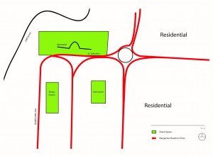
The Parks and Boulevards system in Kansas City, Missouri is one of the largest systems in the world. When August Meyer and George Kessler moved to Kansas City in the middle to late nineteenth century, Kansas City was a dirty and unwelcoming place to be. Due to the success of the Stock Yards and Rail Road expansion, the population of Kansas City grew at an astonishing rate. When Meyer became the President of the Commission of Parks, he helped lead the way for the implementation of the Parks and Boulevard systems with the help of George Kessler, who was the lead designer.
When someone visits Kansas City and is shown the Parks and Boulevards system for the first time they are usually blown away by how large the system is as a whole, and how truly beautiful it is. For the everyday driver who lives in Kansas City, the system may only be viewed for the purpose of being the fastest way to commute back and forth to work or the fastest way to get from point A to point B. Most people do not appreciate its true beauty. If you asked a citizen that lives in Kansas City, what the difference between a Boulevard and a Parkway is, or when the last time they went and walked around Cliff Drive was, you may be disappointed. But what I would ask them, is to name three Boulevards that are not Broadway, Emanuel Cleaver, or Brookside.
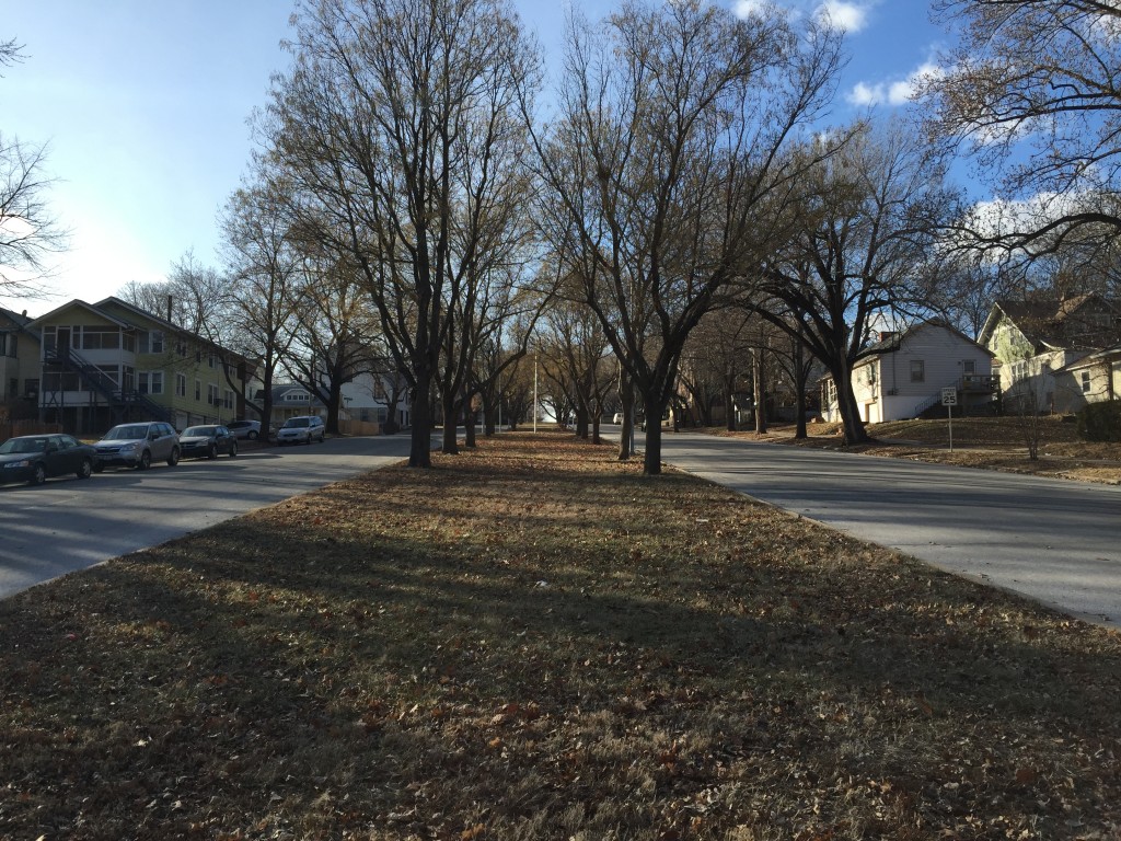
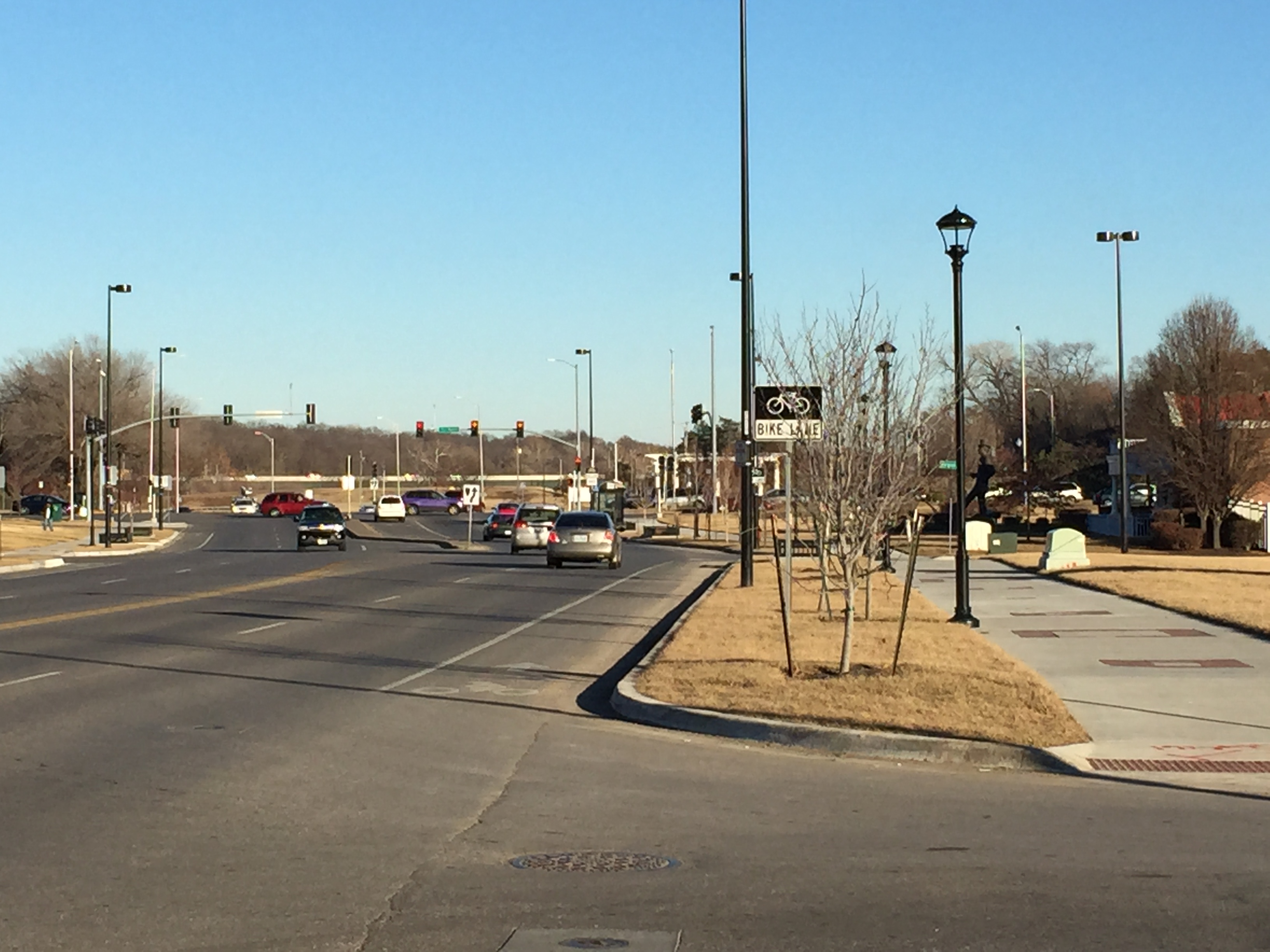
When it comes to describing the Parks and Boulevards system amalgamation, people like myself may be surprised to learn that the system is actually comprised of Parkways, Boulevards, Avenues, Roads, and Drives. Image 1 is a great example of Kansas City’s Parks and Boulevard system. The photo, which is the Budd Park Esplanade, was taken looking west of Budd Bark in the Northeast neighborhood.
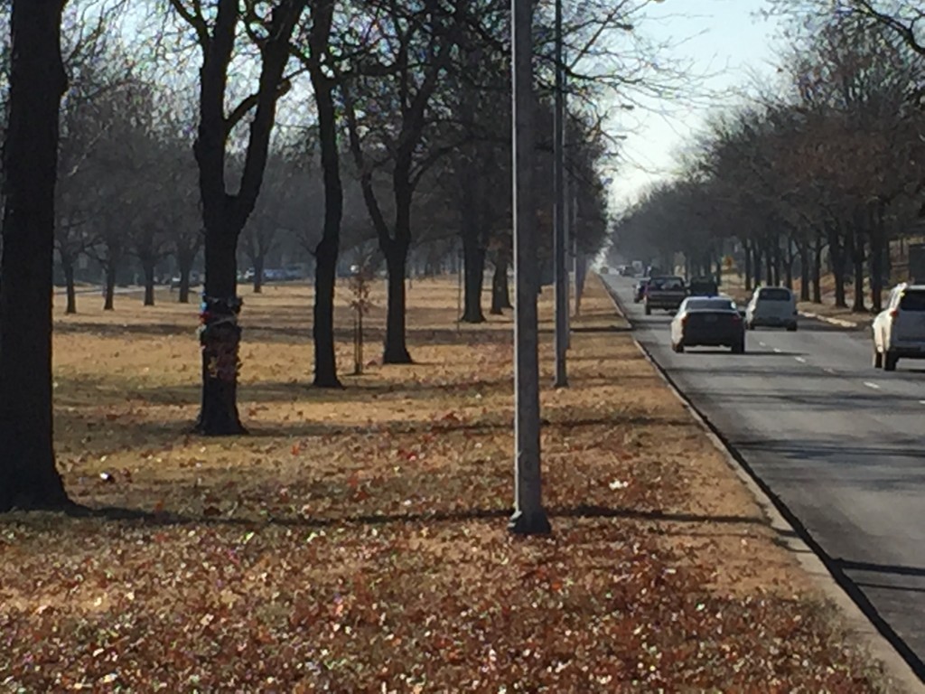
It is known for its picturesque center median and being the main entrance to Budd Park from Van Brunt Boulevard. Image 2, which is another great example of the Parks and Boulevard system, was taken looking south down Paseo just south of East 51st Street. I would like to tell you that it is one of the most magnificent Parkways is Kansas City, but I can’t, because it’s not. Neither is it a Boulevard, or an Avenue. It is just The Paseo. This is just one example of why it is so hard for someone to know what type of thoroughfare they are actually driving on.
According to the City of Kansas City’s Major Street Plan, a Boulevard does not have a center median. Only Parkways have center medians. And yes I understand there can be exceptions, especially when it is needed because of the geography, but this section of Paseo was obviously planned to be like this or it wouldn’t have such a wide median.
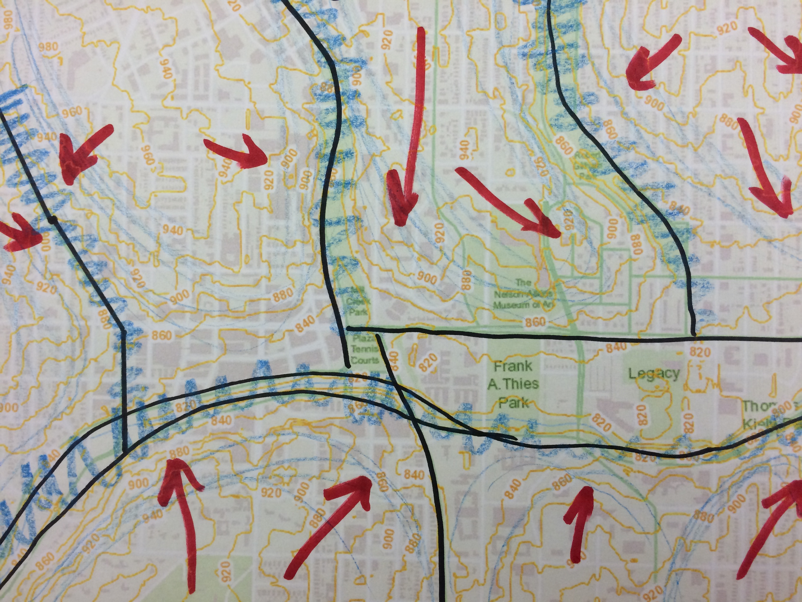
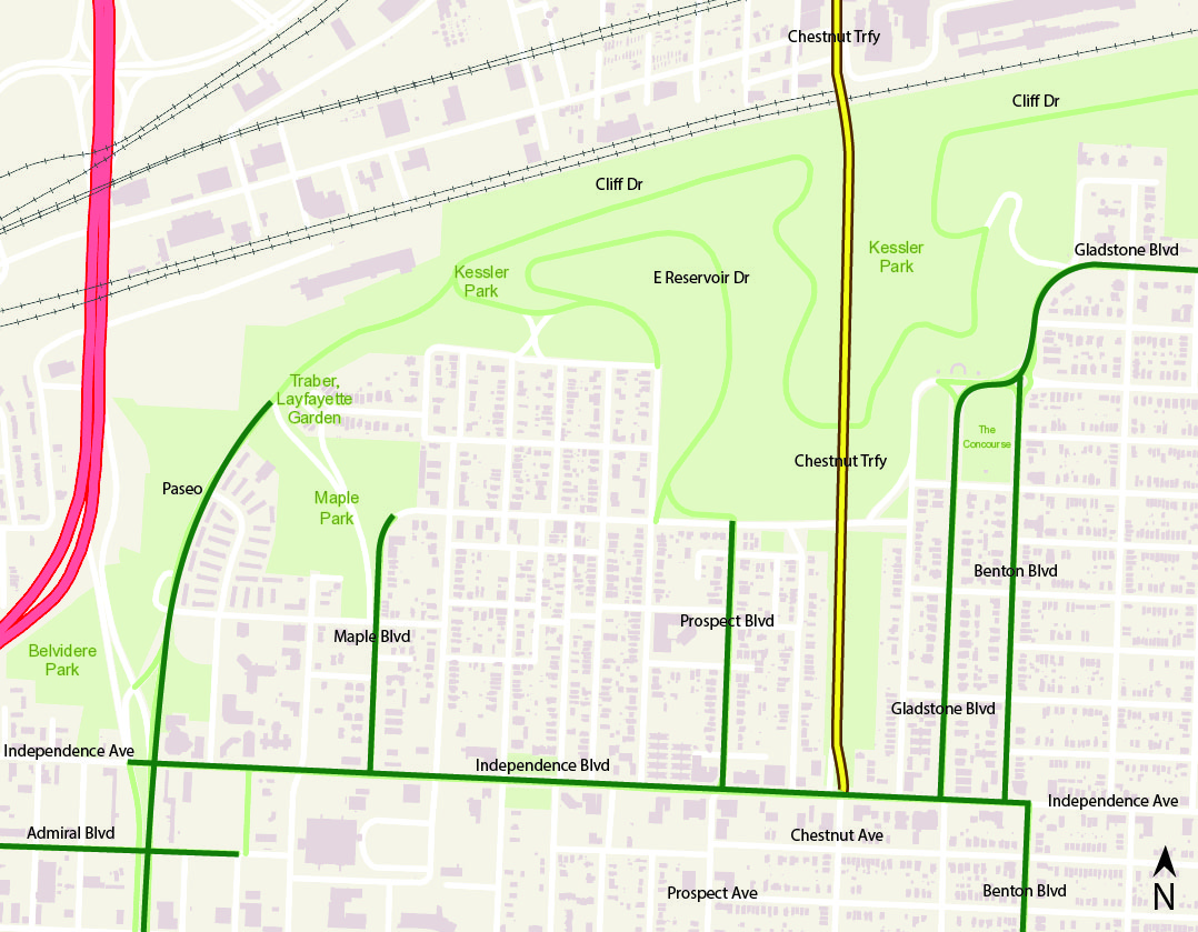
Diagram 1. Source: KCMO Parcel Viewer
Diagram 1 is a major area of the Parks and Boulevards system around Cliff Drive Park. In the diagram I have highlighted and labeled important sections of the system. But what I am interested in, is how and why some street names change along the system. A good example is Independence Avenue, as you can see from Paseo to Benton Boulevard, it is labeled Independence Boulevard, not Avenue. This is fine, and I believe it was planned to connect to the other Boulevards. Another example is Chestnut Traffic way. It shown as part of the Parks and Boulevard System from the railroad tracks down to Independence Boulevard, but why is that section of the road not changed to Chestnut Boulevard or Parkway? Then when you look at Prospect Avenue, the name is changed while apart of the system.
Diagram 2. Source: KCMO Parcel Viewer
In the next diagram (Diagram 2), I have highlighted major parts of the Parks and Boulevard system along Brush Creek. In the diagram, I have Parkways highlighted in yellow, and boulevards highlighted in green. As you can see a couple of the streets were highlighted in both. Roanoke Parkway according to the Kansas City Major Street Plan, should not be named a Parkway because it does not have a center median. It would be better fit as a Boulevard. The other street I have double highlighted is Emanuel Cleaver II Boulevard. Image 3 shows you what Cleaver looks like just east of Troost Avenue, and it is a great example of a newer generation Boulevard.
However Image 4 was taken looking from Clary Boulevard looking north on Cleaver. But what you see is a vegetated median which again should be labeled as a Parkway, but why isn’t it?
These are all great examples of how the Parks and Boulevard system can be confusing to people that would like to explore it but do not know much about it. Hopefully the City will edit the street names for everyone’s sake!
I did not grow up in cities. Until recently I have always lived in or near wilderness areas- areas that have few major roads and where nature and man meet in very different ways than they do in Kansas City. The Parks and Boulevards system is a very intriguing idea to me. To have to actually make an effort to bring nature to a city is still a strange concept. Nature and beauty has always just “been there” no one had to add it back in but it is something that has become more and more necessary as our cities grow and our access to nature becomes less obvious.
Access to green space on a daily basis has proven to be beneficial and vital to the mental, physical and emotional well-being of humans as was discussed at length in an article titled Urban green space, public health, and environmental justice: The challenge of making cities ‘just green enough’. For example, there are strong links between child behavioral problems and access to green space activities or lack thereof and that interaction with nature and animals is important to child development (Wolch, 2014). The ways in which these concepts are surfacing vary from green building designs to improving connections between the city and parks. Kessler’s vision for Parks and Boulevards system may have been conceived of nearly a century ago but it has very relevant and applicable components today.
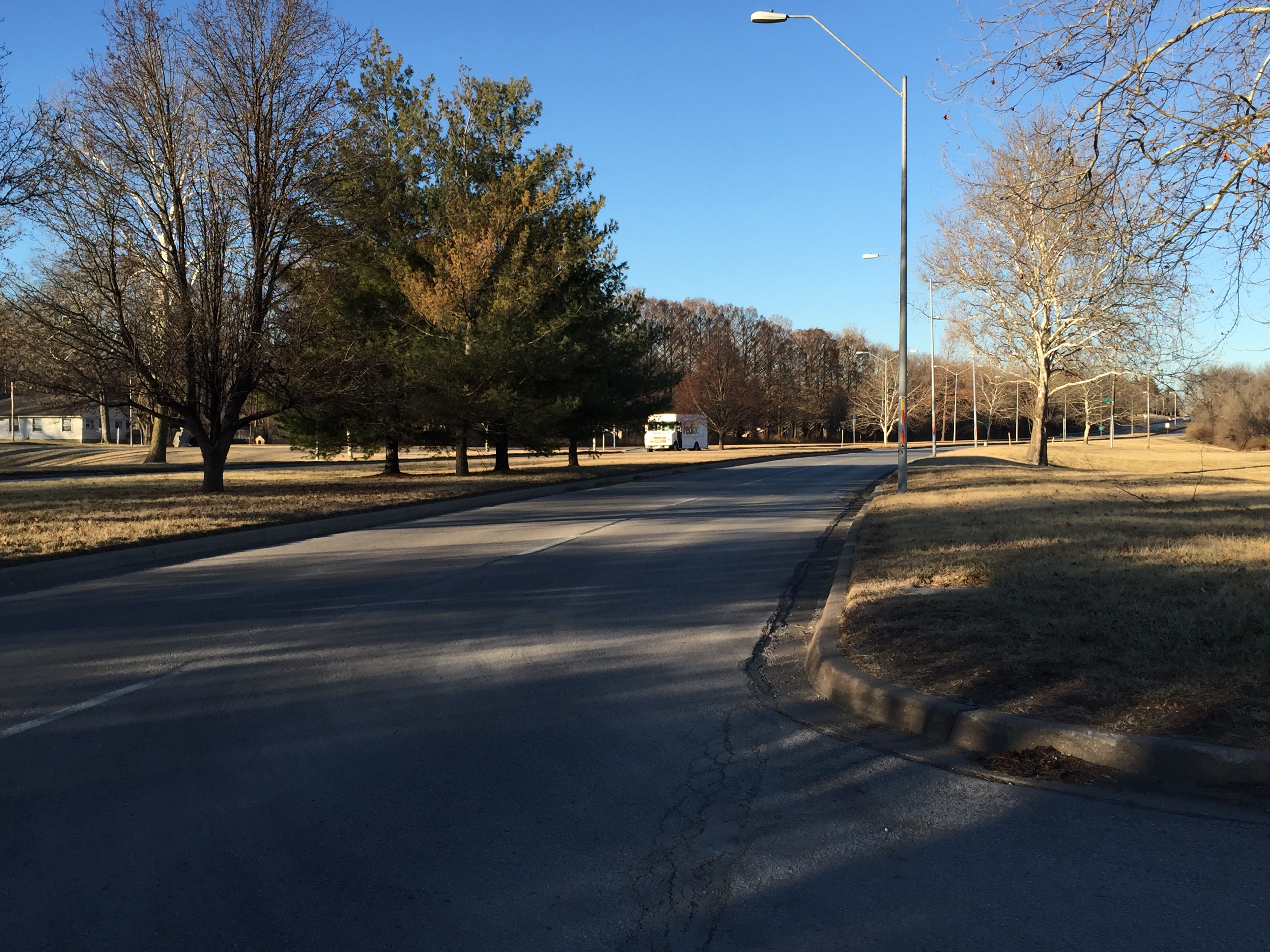
Troost Lake
While driving the Parks & Boulevards system in Kansas City, with a little bit of background information in tow, I can imagine what it was like in the 1940’s to go for a leisurely family drive on a Sunday afternoon and perhaps stopping along the way at Troost Lake for a picnic (Yes, I said Troost Lake). The slowly curving, wide lanes winding through beautiful homes, parks and memorials along the way. With as few cars on the road as there was then I can imagine this to have been a pleasant and enchanting excursion. Today, though there are strong remnants of past intentions evident, we are not living in the same century and many things have changed since the P&B (Parks & Boulevards) system was envisioned in the early part of the 1900’s.
Many of the neighborhoods and destinations that this system runs through and to are now run down and not as well maintained as they could be and are for the most part underutilized, with a few exceptions. The whole system feels disjointed and confusing and while driving through it there doesn’t seem to be a natural flow of the connecting boulevards. I don’t live near the system and when I owned a car I avoided it because it was inefficient, so prior to being given the background on parks and boulevards system I really didn’t understand what was happening with Kansas City streets at all. I found it unclear, fragmented and seemingly random. For instance, the pavilion structure on Paseo between 11th & 12th, it has always seemed arbitrary and out of place to me. I didn’t understand the purpose of such a structure in that particular location, and the people that first introduced me to Kansas City couldn’t give me any information on it either.
Paseo at 11th & 12th
“Do people go there? What do you do there? Why is it there? Why would someone spend a bunch of money building something like that that no one ever uses and can’t use?” None of my tour guides could answer those questions- they only laughed and took me to Loose Park. Clearly the idea of the parks and boulevards has been lost on this city and its new residents.
I do not own a personal vehicle and I rely largely on public transportation, walking or cycling to destinations so the appeal of such a car-centric system is largely lost on me in the first place and it also causes me to be much more sensitive to issues with alternative transportation. There are bike lanes and sidewalks that randomly start and stop, as if someone started a project and midway through and got distracted by something shinny somewhere else and moved on. There is a serious lack of parking at the many stops along the P&B system so if you are driving it seems as though no one wants you to actually stop. I can’t tell if these memorials and parks were designed to have people visit or not. Many of them have benches which would make them seem as if they were welcoming to the public, or at least were once, but the access to them now is hazardous at best especially by bike or foot and lack parking otherwise. (at least this is my experience with the few that I visited) Though there are clearly attempts being made to improve and maintain this system in Kansas City, the overall feeling is one of confusing unimportance.
Kennedy Memorial on St. John AveRenovation efforts made at the Kennedy Memorial
An example of this is at the Kennedy Memorial at St. John’s avenue and Bellefontain Ave. It is an absolutely amazing structure that I would love to go spend my lunch break at. It seems to be well maintained and it appears that there is work being done to repair and reinvigorate the site, but getting to it would be an absolute nightmare if you weren’t in a car.
There are no sidewalks or bike lanes and a confusing parking situation. Are you supposed to stop here? Am I parked in the street? There is a tennis court and another green space next to it as well as residential area and a very busy street separating all of these things with no way to cross it safely. There are many missed connection opportunities that could bring this space to life in a different way. I would go there if I could get there alive.
Accessibility issues with Kennedy Memorial
Another, just odd personal realization I had while wandering around these parks was that I I have an aversion to walking on lawns, and I’m thinking I’m probably not the only one that does. I feel like I’m walking on someone’s nice white carpet with muddy boots- any minute I’m going to get in trouble! Some of the stops along the way have this don’t tread on me feel to them. Like Bud park. It is a beautiful and huge space with lots of paths and grass… should I walk on it? What does one do with all that lawn? It’s like a painting. It serves no purpose other than to be seen, but it is sure missed when it isn’t there. If these are really supposed to be actively used how do we promote their use?
Budd Park
Though the idea of introducing and maintaining nature in an urban context is a different concept for me it is perhaps more valuable and necessary in an an area like Kansas City than the places I grew up. Overall, once I understood the big idea behind the P&B system, I found it to be beautiful and loaded with potential. We are fortunate in Kansas City to have so many parks available to us and it is sad to see so few of them actually being used for their intended purposes any longer. The system as a whole is not necessarily valued as the amazing resources for activity, community engagement and overall health and well-being of the residents of Kansas City and it should be. It is time to refocus its value, involve the communities in positive ways and update the system so that it can be move into this century and beyond. And though it is highly unlikely that any of us in Kansas City will have the experience of crossing paths with a black bear on our walk through Budd Park the experience of the walk itself is no less valuable and vital.
Wolch, J. R. (2014). Urban green space, public health, and environmental justice: The challenge of making cities ‘just green enough’. Landscape and Urban Planning (125), 234-244.
Living and growing up in the Kansas City Area, the concept of parks and open recreational space is nothing new to me. However, it wasn’t after beginning this project, visiting and surveying multiple parks throughout the area that I really began to feel and understand the complexity of Kansas City’s Parks and Boulevards System.
One of my immediate observations in researching the public space throughout the city was not only the number of parks, but the contrast of park conditions. Between both the quality of park space, and the use of park space, it is evident that some parks throughout the city are better utilized than others, and depending on the time of year, or even day, the number of park-goers in each park can be drastically different. Take for example, Budd Park, which I visited on a sunny afternoon. As you can see, when I arrived, the park and its surrounding were completely bare. However, shorty after school let out, it quickly began to fill up with younger aged kids, and their parents.
Looking east from Budd Park- Budd Park EsplanadeTrash along Troost Lake Shore
On the other hand, we have Troost Lake, which was visited on a different day, around the same time. Not only was this park completely empty, aside from residents across the street, but it was poorly maintained in comparison to other locations in Kansas City’s park system. The path around the lake was nearly non-existent and muddy, and the shores of the lake were littered with trash, dead fish, and animal feces.
So why is that? Why are some parks better maintained than others? Why is there a crowd of people at this park, but nobody at that park? In my opinion it’s all about the amenities that a park has to offer. Some go to socialize and relax, while others use them for physical activity. Another thing that was clear to me was the range of activities promoted by each park, from passive activities to active activities. While several parks around the area simply house trails that promote walking, jogging, or biking, such as Mill Creek Park, others, such as Gillham Park, just south of 39th Street offer amenities such as tennis courts, playgrounds, and even a baseball diamond.
This is the blog of the 63rd Street Studio, a product of the the Spring 2014 UPD 312 (Junior-level) Urban Planning +Design Studio II in the Department of Architecture, Urban Planning + Design at UMKC.
for more information contact: frischm(at)umkc(dot)edu