This design concept considers the possibility of an east to west BRT route traveling from Independence, MO to Village West, KCK. The location of this particular hub is near the intersection of State Ave and College Pkwy in Kansas City, KS. In this particular stretch, the route travels west on State Ave, turns north on College Pkwy, and then resumes its route west again on Parallel Pkwy. The area overall is relatively low in activity compared to its eastern acquaintances closer to KCK and KCMO. A declining commercial strip hugs State Ave, while newly constructed logistical warehousing occupies the southeast corner.
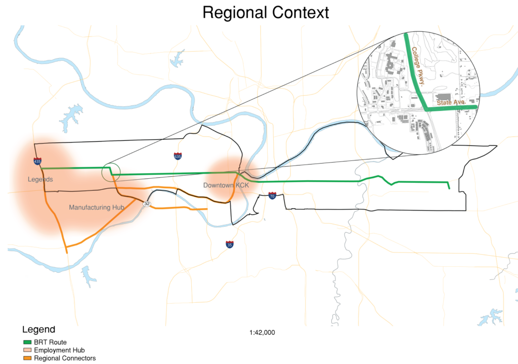
The area has one unique asset however, and serves as the backbone of this design concept. Kansas City Kansas Community College is located in the northwest corner of the intersection, where roughly 3,500 students attend on campus during the school year. The campus presents a unique opportunity to construct a mobility hub to provide both regional and local connections to students.
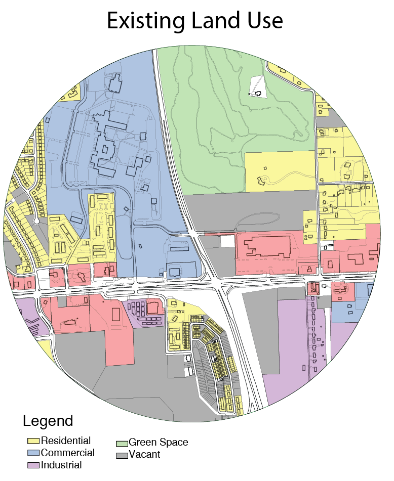
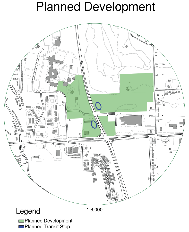
The conditions of the area encourage the epicenter of the hub to be just north of the major intersection, where College Pkwy meets Delaware Dr. There are a few driving forces for this center. Firstly, it provides convenient proximity to the campus. Secondly, it takes advantage of large swaths of vacant land on the east side of College Pkwy. Lastly, it prioritizes safety by keeping distance between the hub’s center and the high traffic intersection of State Ave and College Pkwy. Locating the hub closer to the intersection was decided against due to the potential challenges of merging a BRT route directly into a large intersection while simultaneously changing route directions from east-west to north-south.
Another factor of this decision was the recognition that College Pkwy is one step away from becoming a freeway. Indeed, south of State Ave, College Pkwy turns into Turner Diagonal Fwy, which serves as the main connector to the area for commuters that are traveling on I-70. I expect that vehicles traveling on College Pkwy routinely reach speeds upwards of 60 MPH, considering the official speed limit of 55 MPH.
Due to the traffic conditions, there lies a major fork in the road in terms of potential design. One may either see the high speed traffic as an opportunity to implement traffic calming measures, or one may embrace the existing infrastructure and present design solutions to compliment the existing site. This design chose the latter. There is likely the case for the former solution; in my opinion, it is the more attractive solution, and will likely be effective in the majority of cases. In this instance however, there is no evading the immediate connection that College Pkwy has to its conjoined twin: Turner Diagonal.
Because of this condition along with the quest to produce an effective mobility hub regardless of location, the primary design considerations for this hub were safety, transit specific amenities, housing options, economic stimulus, and local connections.
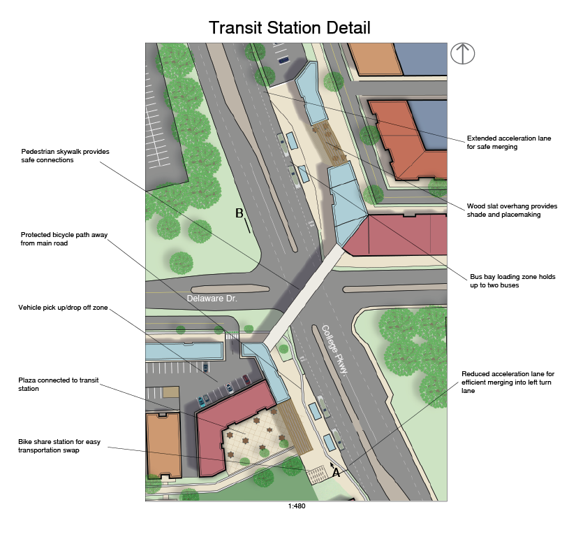
Safety considerations were primarily implemented in the nearby development of the transit stops. Both the east and west stops are developed inwards towards the center of each block, rather than adjacently along College Pkwy. Each stop features a grand gateway leading into the block that feeds commuters into public and commercial spaces, complemented by pedestrian and bicycle infrastructure that connects to the rest of the development. Besides safety, this design choice overall goes with the grain, as opposed to against the grain of development. Developing inwards, rather than adjacently along an arterial road seems counter-intuitive. However, the lack of development and existence of major facilities along the north-south arterial presents very little opportunity for expansion or developing infrastructural connections along College Pkwy. Additionally, this concept blends with the campus environment, where pedestrianization dominates compared to the rest of the existing site. Embracing the significance of safety further is a pedestrian skywalk that connects the two transit stops from the second floor of each respective transit facility.
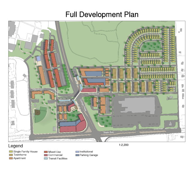
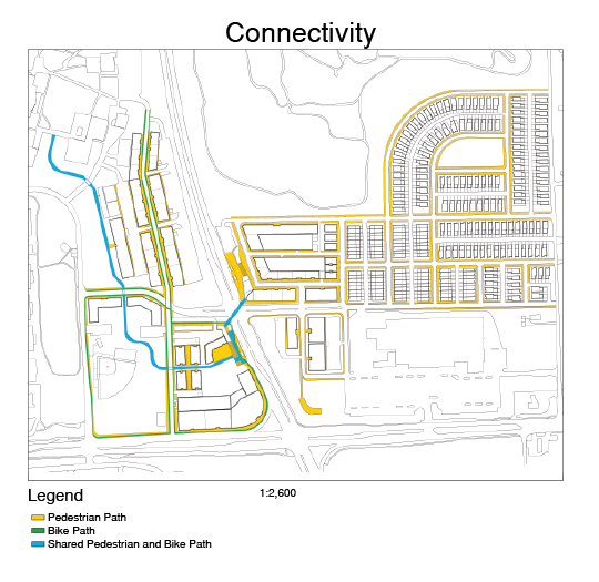
The design embraces the traditional mobility hub concept of an area meant to handle the transfer of varying types of transportation. The design expresses this primarily through its robust bicycle and pedestrian infrastructure, which features a shared pedestrian and bicycle path beginning centrally with the skywalk, and traveling northwest until its eventual connection to the community college. The transit sites feature a bike share system, vehicle pick-up/drop-off zones, and transit specific commercial development meant to include a welcome center (resembling an all-in-one space resembling a community center), as well as vendors such as bike shops. Each stop has a slightly different public/commercial space connected to the stops. The western stop leads immediately inwards towards a commercial plaza, while the eastern stop leads inwards towards a small, mixed use corridor.
The mobility hub design is not only meant to connect commuters to commercial development and the community college, but also to the planned residential units. Residential units nearest to the transit stops are strategically placed: Close enough to provide convenient access to the hub for those who value transit, yet far enough that a “residential feel” is still intact. Overall, the development includes slightly over 1,000 residential units taking the form of five available housing types: Single family homes, townhomes, six-plex colonnades, three story apartment buildings, and two-over-one mixed use units.
Single family homes take a large part of the available real estate in the eastern half. They are meant to act as a buffer between the denser development of the hubs center, and the low density character of the nearby neighborhood in the northeast. They are constructed in a new urbanist fashion, choosing to embrace connectedness to the street over disconnection through large setbacks. Short, 10 ft setbacks, combined with rear-loaded garages encourage pedestrian focused street activity. Recognizing the demand for private space, in addition to the quest for connectedness, the private spaces take influence from Christopher Alexander’s half-hidden garden. 15-20 ft private spaces on the side of each home provide a space that feels private, yet also provides some connection to the street. although this limits the overall potential density, the closeness of the property to the street took priority for establishing a sense of community.
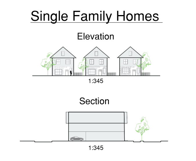
The rest of the housing development was designed with a similar philosophy of establishing community, although through density-favoring approaches with communal outdoor spaces rather than individually private ones.
The entire development is planned to grow in four different phases over a fifteen year time-span. After a small demolition phase which will include some minor grading, development will begin in Phase II with the transit stops, immediately adjacent residential and commercial, as well as the road and path infrastructure to lay the foundation for Phase III. The third Phase will fill in the infrastructure set by the previous phase with the majority of residential and mixed use development. The end of this phase will also lay the road infrastructure for Phase IV. The last phase will finish the SFH housing development in the northeast, and will finally recognize the intersection of State Ave and College Pkwy. to be a viable zone for pedestrianization.
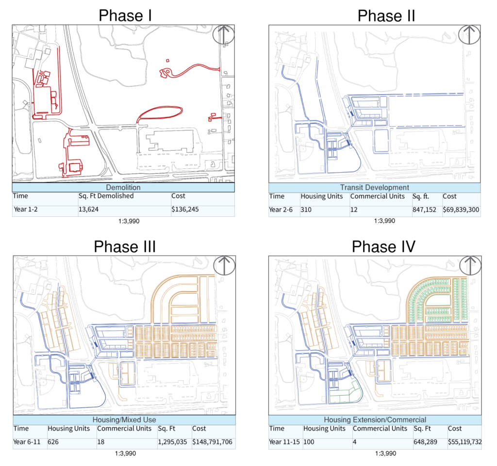
After the BRT route has been well established, and the initial development has had time to increase consumer demand, the development of larger commercial fronts along the northwest corner of the intersection will be appropriate. This will likely mark the time when traffic calming measures along the major intersection will see higher demand as development trickles south across State. Ave, particularly on the west side where there are potential connections to the community college waiting to be made.
Overall, the hub represents the potential for innovative, transit oriented development in the Bi-State Corridor. The hub presents solutions for connectivity, housing, commercial, and pedestrian safety in the areas while also blending into its environment. The development will be a $273,000,000 investment that will prove to be well worth it as it continues to drive development opportunities well after its completion.