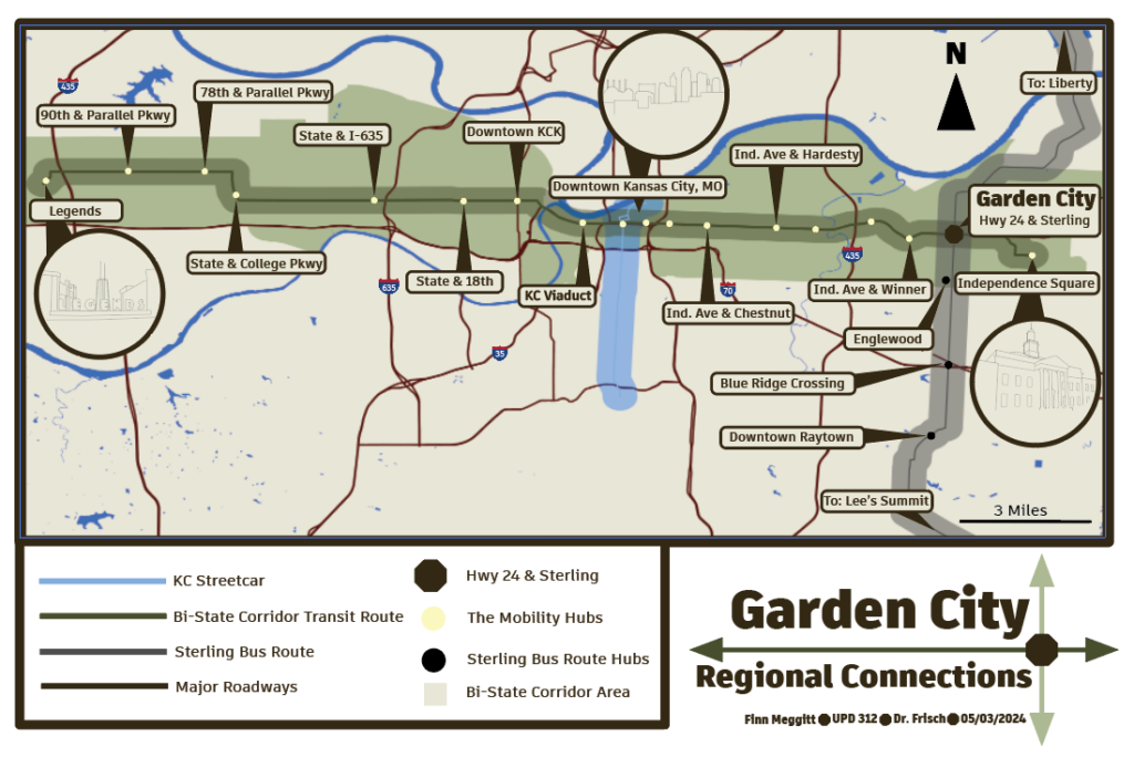
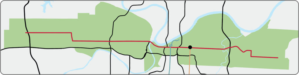
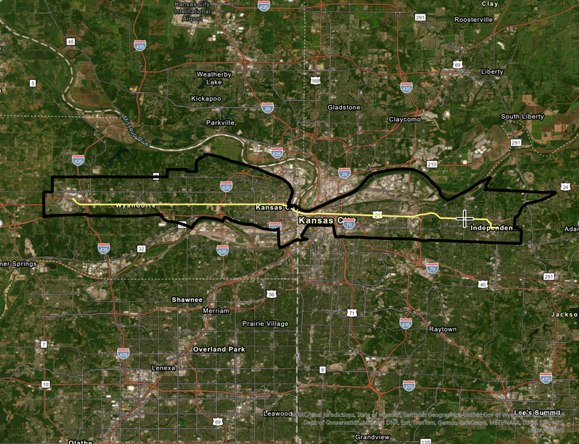
The regional connections board explains the context for the Bi-State Corridor transit network and its respective mobility hubs. The proposed corridor goes from Independence Square to West Village, or the Legends. This map also includes the proposed creation of a Bus Route from Lee’s Summit to Liberty which will connect this mobility hub to Englewood and Raytown.
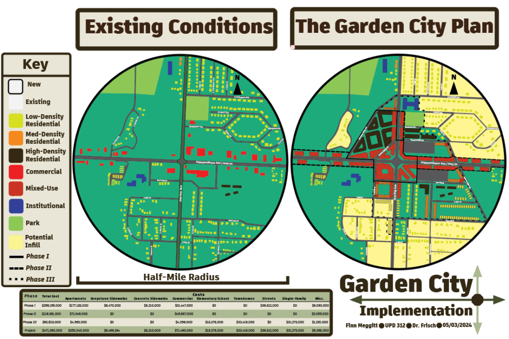
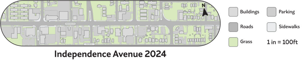
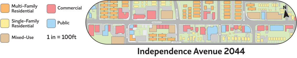
This shows what changed from the existing conditions to the development. The mobility hub currently supports an unplanned area of suburban and exurban housing in combination with commercial pads and strip malls with large front and side setbacks. The area changes into a dense core which can support transit, unlike the current existing conditions. This density will help keep out of the flood plain and create a more sustainable area which will make residents healthier.
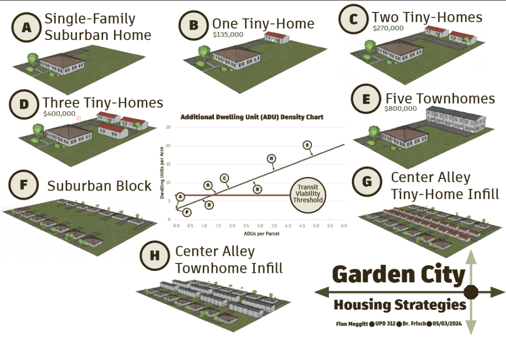
Housing board which illustrates how many ADU’s would be necessary to create the necessary density for transit in suburb and borderline exurban areas. A through E are free market solutions which allow residents to freely manage a construction project in their own backyard. F through H are solutions where the government eminent domains your backyard and turns it into housing.
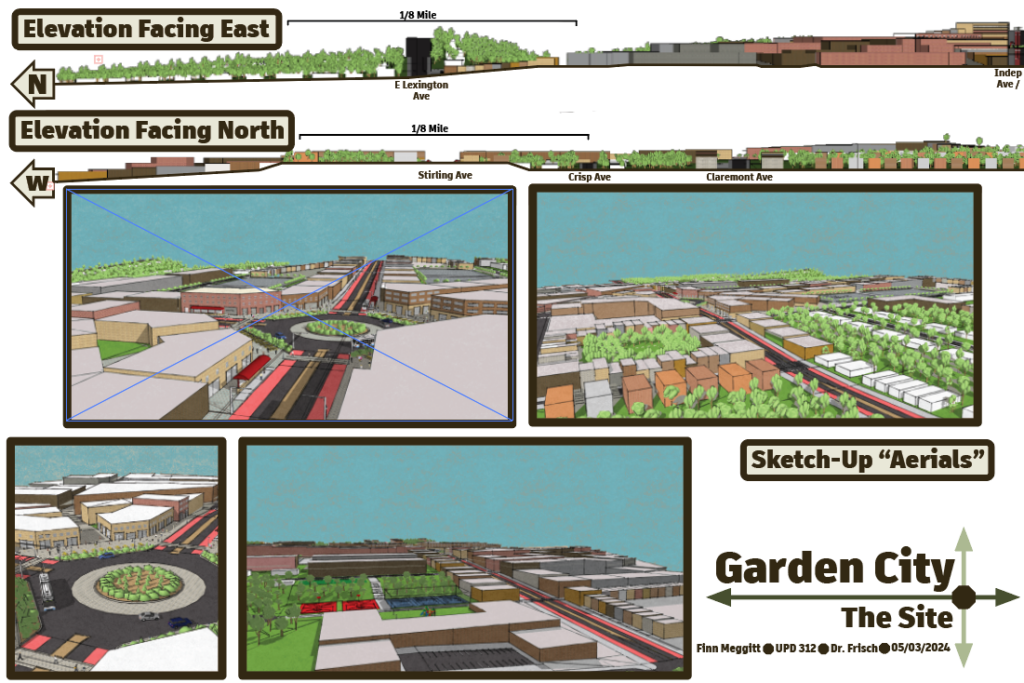
This board shows what the project looks like. You can see the greenery and more forested and lower and medium density buildings which create more private areas for families. You can also see the elementary school on this board as well as the dense core of the project area.
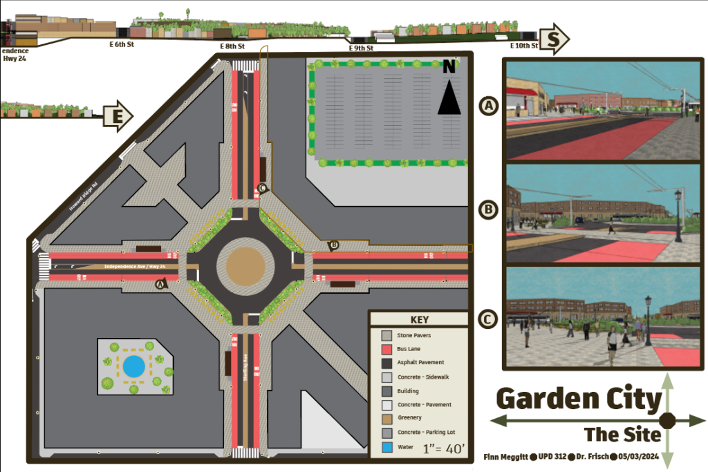
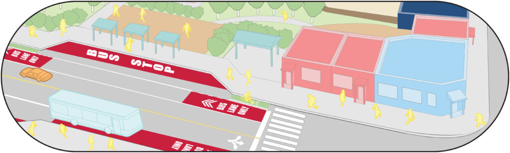
This is what the center of the mobility hub looks like, its the right board. The board shows the human scale of the mobility hub as well as the four bus stops within the mobility hub. The perspectives are labeled on the mobility hub and you can get a complete view of the center of the mobility hub. The area has bulb-outs, planters, raised crosswalks, and bus lanes.
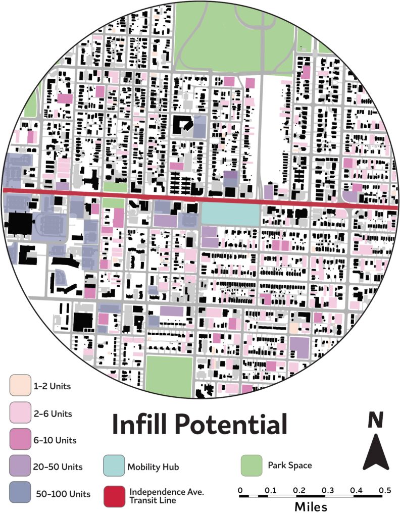
Project KC Moves is a design for one section of the larger Bi-State Reinvestment Corridor Transit route. It combines the goals of sustainability, re-imagined housing, community strength, and improved mobility in a design centered around a mobility hub at the intersection of Independence and Prospect Ave.
What is the Bi-State Corridor?
The Bi-State Reinvestment Corridor is a project created by Missouri Representative Emanuel Cleaver II and Kansas Representative Sharice Davids using federal money from Bipartisan Infrastructure Deal. The main goal of the project is to create a rapid transit line from one side of Kansas City, to the other. Along with this transit line, this project provides an opportunity to invest in our city; specifically, to improve transportation, housing, workforce development, and green infrastructure. Project KC Moves is one part of the larger Bi-State Reinvestment Corridor.
The goal of Project KC Moves is to design one of the 10 potential mobility hub sites identified in the corridor. Along with the creation of the core transit stop, Project KC Moves also design the structure of development as is spreads throughout the corridor. This includes reimagining housing, Independence Avenue, and mobility in the area.
Existing Community
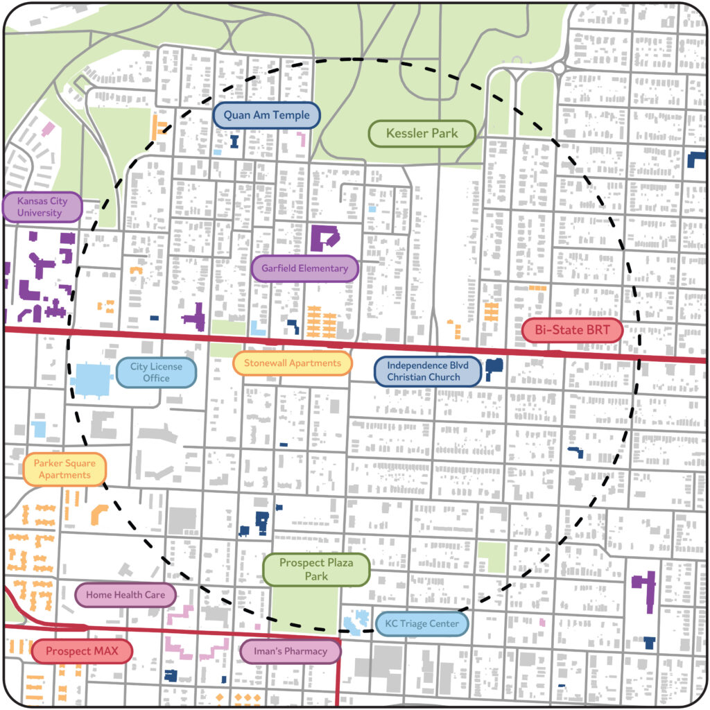
The project area centers around the intersection of Independence Ave. and Prospect Ave, and the half mile radius around it. The existing neighborhood is unique in that it is already densely populated and heavily developed. The area contains many churches, schools, parks, and small businesses.
The vision for Project KC Moves is to combine the existing assets of the neighborhood with the resources of the Bi-State Sustainable Reinvestment Corridor to create a walk-able area well connected with different modes of transit.
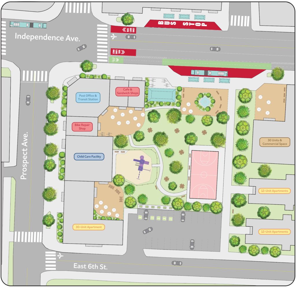
Mobility Hub
Some of the center features of this mobility hub include a combination Post Office and Transit Stations. The station will function as a normal post office, but also hire someone to be in charge of the mobility, as well as answer any questions about transit. On either side of the station are small commercial shops, including a bike repair shop, and a sandwich and cafe, encouraging people to fully inhabit the space. Below that is a large child care facility to support families in the area. Below that is a 30 unit apartment building model after the Pendleton Arts Block, just a couple blocks away from this development. The central area of the mobility hub acts as a park space to be used by anyone in the neighborhood, whether they be waiting fro transit or not.
Independence Ave.
Outside of the mobility hub, Project KC Moves invests in a larger section of Independence Avenue. After the twenty year implementation period, Independence Avenue will have many more commercial buildings right on the street, creating a more coherent pedestrian experience. Because of the importance of considering the needs of the community, Project KC Moves uses existing buildings wherever possible, and always draws inspiration from the neighborhood.
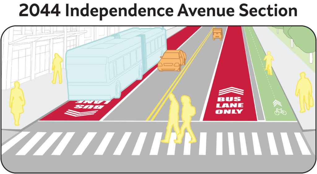
Along with the building morphology, Project KC Moves also invests in the street infrastructure, ending with a final design including a single, two-way bike lane and two bus only lanes, reducing the car traffic down to just one lane per direction. While this is an ambitious plan, its implementation would truly get to what it means to be multi-model, and would give the freedom to residents to choose their form of travel.
Housing Strategy
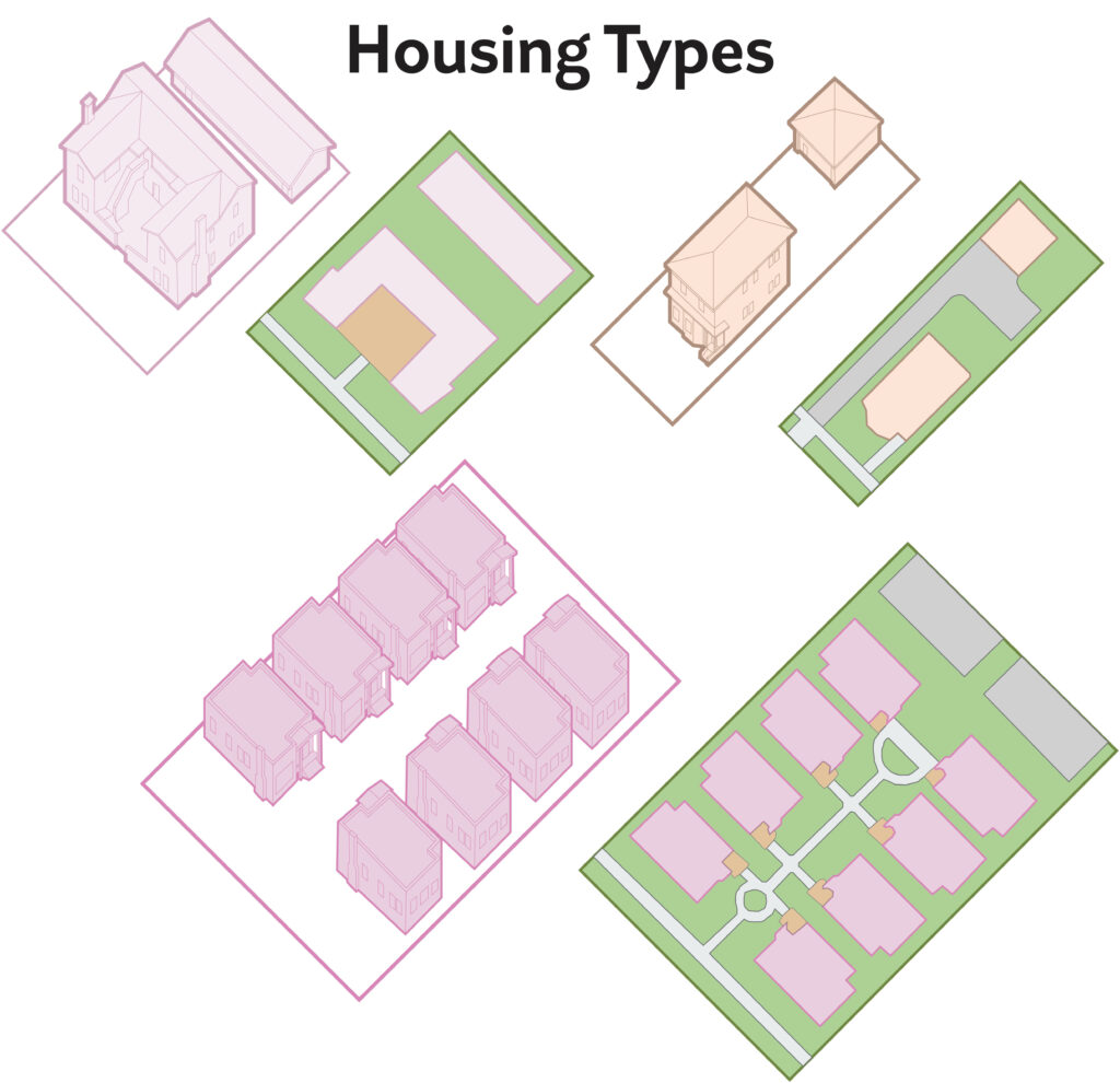
Project KC Moves’ housing strategy begins by highlighting all the empty lots with the half-mile radius of the mobility hub, and then sorting them by size. For each size, Project KC Moves suggests a different housing infill type. Implementing this strategy would increase the number of units in the area by over 2000, creating the kind of density needed to support a transit line.
By 2044, the Independence and Prospect Ave. area will complete its infill process. Project KC Moves uses several different housing footprints to fully utilize the space and to increase density. By only utilizing the densest housing Project KC Moves keeps costs down in utilities and land acquisition.
Conclusion
As places with Kansas City are faced with more challenges from climate change, they will need to look towards projects, like Project KC Moves, that allow people to live more sustainably. Projects that overall increase density, encourage use of transit, and create greater connectivity will be the key to transitioning to a greener city. Project KC Moves commits to these challenges and implements their solutions at a human scale.
For elements of the public realm I was assigned to focus on street furniture and figure out what makes good street furniture? Is it more than just a place to sit or can we make it an interactive public feature to all. I did my research by going to places in my section of the bi-state corridor and really looked for these places that are more than just a place to sit.
Above are the six images of the Places where I found examples of street furniture. This ranges from actual street benches on street car stop and at the river market to different furnishings such as a statue in the median and even a fountain that can offer seating. These elements are great in focusing of where our ideas and design can move towards making great street furniture.
Above are my first to boards of my presentation. If you can notice I tried to make these boards with as much detail as possible, even adding small hints of street furniture at the top of the boards with a bench and a street light and even some recycling bins these are things that I’ve tried to add as street furniture is about the details and how they are minimal but when you focus on them you realize they matter. I believe that makes good street furniture, not the intricate design that may be outlandish, while it is nice to have great designing and unique street furniture, functionality is an important part of it. In the public realm having street furniture such as a bench to sit or rest is important as well as a bin to dispose of trash and/or recycling and some shade from the sun or rain are basic elements of street furniture that should always be kept in mind when designing a place for the public to sit. An example of how we can improve an area with street furniture are our street car stops, they don’t have enough room to sit there’s only one bench on the stop and any attempt to sit on the concrete would be physically uncomfortable for most people to squat down and sit. Just by adding a bigger sitting area and standing room people would be able to not have an uncomfortable time waiting for the street car. This would also include additional trash and recycling bins to make sure riders keep it as clean as possible.
Street furniture is everywhere and I believe after this project i can say that I have grown an even better understanding and appreciation of street furniture and howe it is an important part of urban design that should not be undervalued or overlooked.
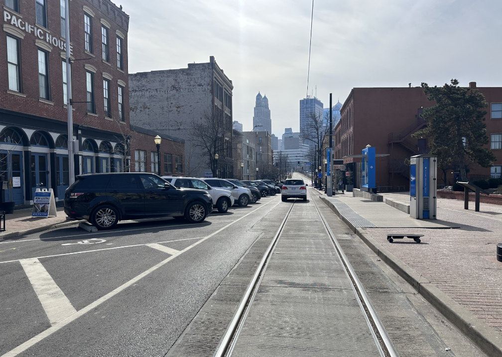
For my section of the corridor I was able to ride around and explore the river market neighborhood. In this neighborhood I was able to understand the role that public transportation plays. I was also able to pick out how the street car is a great resource for the residents in the neighborhood. It allows for people to commute across the downtown area and soon into the plaza. In relation to the corridor it is a great example of how expanding our transit system to neighborhoods like the river market.
In these pictures above you can see that the different materials that go into the street and its surrounding area, going from brick to pavement to asphalt. This bring is it together to allow for public transit to work while also still allowing for vehicular traffic to occur.
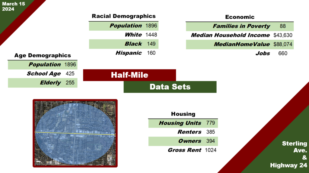
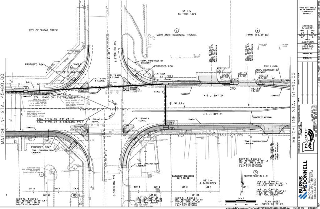
My selected mobility hub is at the intersection of Sterling and Hwy 24 (Independence Ave.). The area is suburban in character and is in an awkward spot between the older, historic Independence and the Blue River Valley.
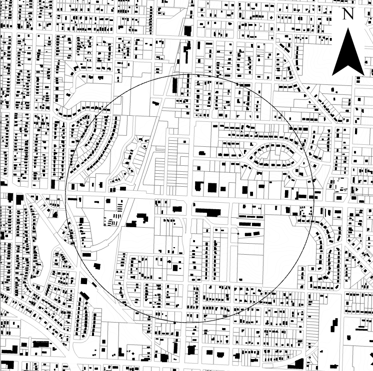
The area has a low, non-diverse population. The area is affordable with low rents allowing people with tighter budgets to live here. This aspect of affordability is important to the development of the area. The area also doesn’t have many jobs, there are 10,000 people within one-mile and only 2,700 jobs. The only change in the data between one-mile and a half-mile is that there are more people of Hispanic and Latino descent within one-mile.
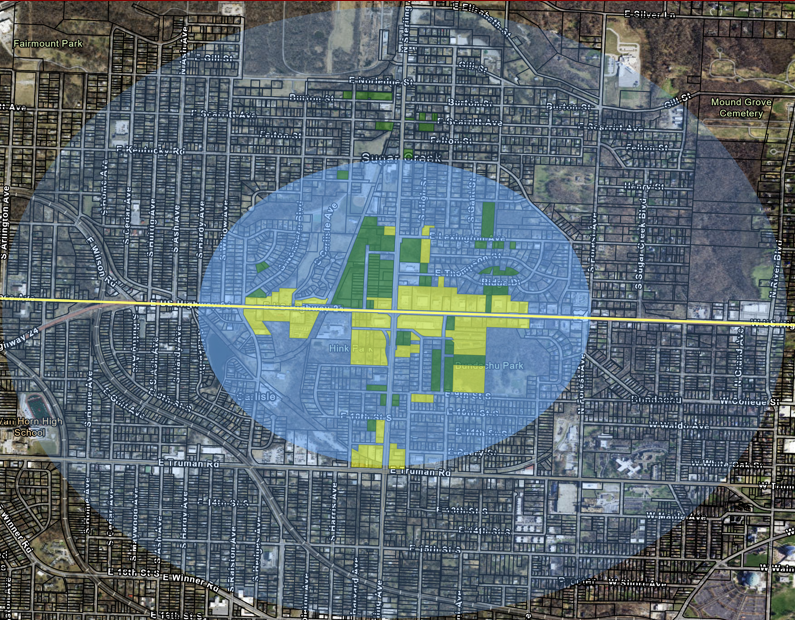
The areas in green a vacant lots that are prepared for development and the yellow are lots that are underutilized and could be redeveloped with ease. There is a lot of opportunity for redevelopment within the half-mile area.
City of Independence, City of Sugar Creek. (2006). Sample Concept for U.S. Highway 24 and Sterling. City of Independence. Retrieved 2024, from https://issuu.com/cityofindepmo/docs/us_24_highway_corridor_strategic_plan.
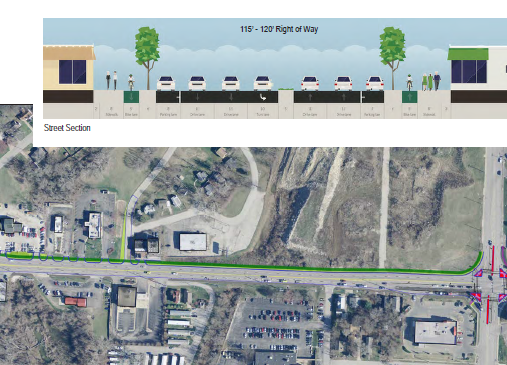
The above image is at the intersection of Hwy 24 and Sterling, my mobility hub. The area, since 2006, has been reimagined as a mixed use area that can support density. This also explains why the Four Trails Neighborhood was demolished between 2007 and 2009.
MARC, MODOT, City of Independence. (2006). Fairmount District Plan. MARC. Retrieved 2024, from chrome-extension://efaidnbmnnnibpcajpcglclefindmkaj/https://www.marc.org/sites/default/files/2022-09/PSP_Projects_2017_Independence_Fairmount_District.pdf
The MARC 2017 plan also designates this area as mixed-use and in the image above demonstrates the improvements to the intersection to facilitate the type of development they want to see. Neither the 2017 or 2006 plans have come to fruition until recent intersection improvements.
City of Sugar Creek. (2014). Four Trails Landing Replat.Jackson County Public Records. Retrieved 2024, from https://aumentumweb.jacksongov.org/RealEstate/SearchResults.aspx?pg=2
The above plan is what was mapped out in the previous MARC plan, illustrating that planning efforts have had a more significant impact in recent years. There might be energy for further development of the area.
The figure ground above illustrates the amount of opportunity for the area as there is a lot of vacant land, and according to recent research, is usable and safe to develop on. Safe, developable land is less common in Sugar Creek than other jurisdictions. The plans from previous years show that the area is ready for development and that there is political will to reimagine the area completely, giving infinite leeway for how this area can be reimagined.
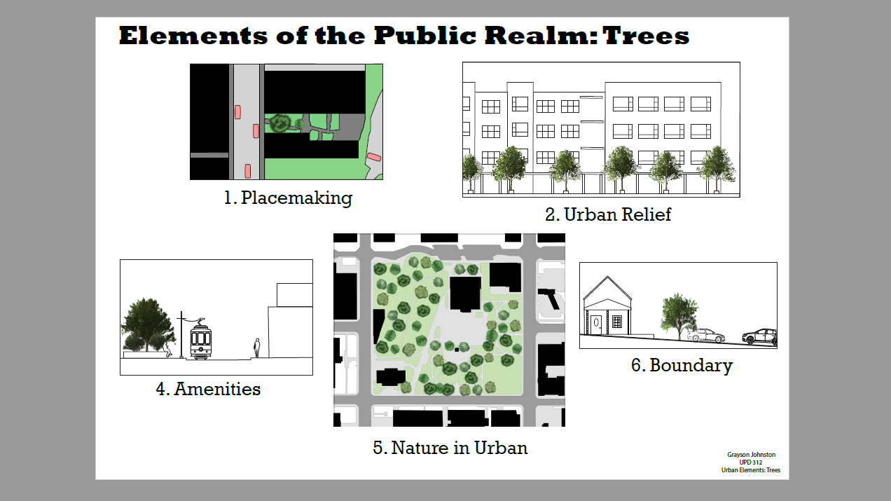
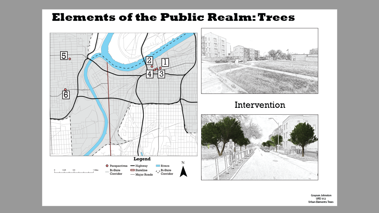
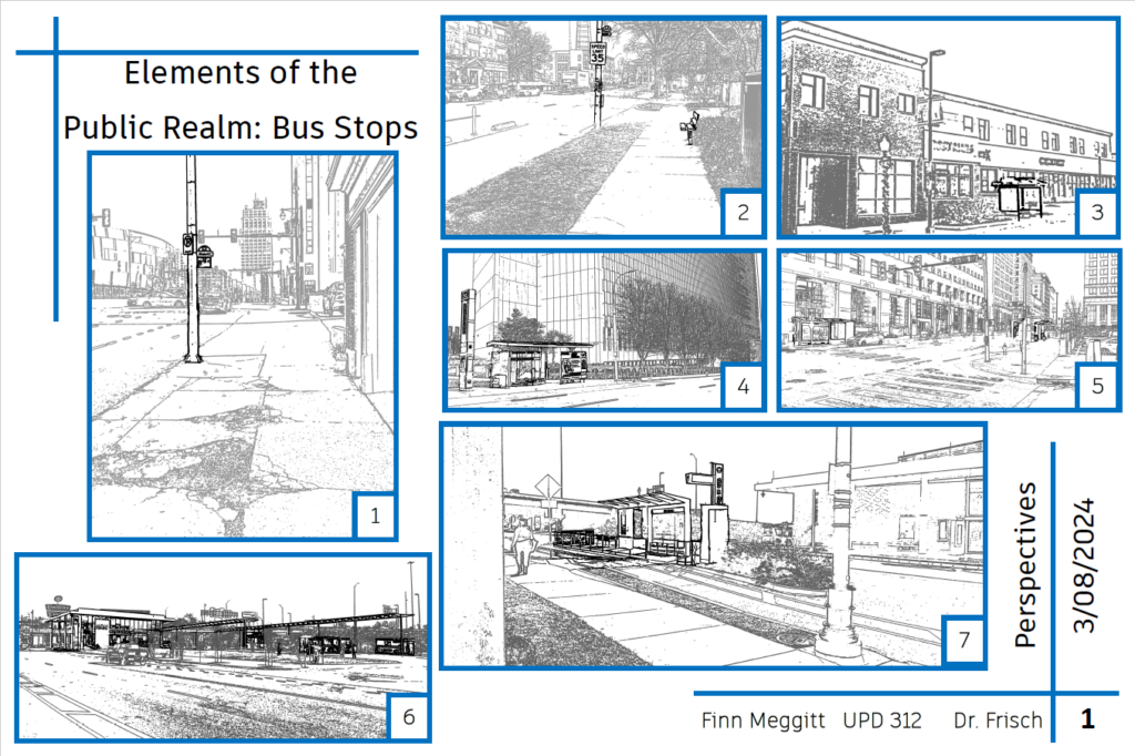
The Elements of the Public Realm project was an urban theory project I completed in the second semester of my junior year at UMKC’s Urban Planning program. For this project, our studio split up and all took different public elements, such as street furniture, transit stops, bike infrastructure, and mine: trees. The goal of the project was to find examples within Kansas City, and use those examples to create a theory of that element. So for my project, I defined the theory of urban trees with the boards below.
I valued this project because it allowed me to advance my skills with image manipulation. As this project was on a particularly short deadline, advanced my skill with Adobe Photoshop and Illustrator to produce these image at high quality. This project additionally allowed me to advance my skill with Illustrator by compelling me to create sections and elevation using the program. My favorite part of the project, though, was presenting this project to explain the theory of it. For most projects I have completed, the goal is to create something presentable and consumable for the public. Alternatively, this project required us to think more like academics and less like public servants, which was a welcome change. Focusing on planning from the point of view of theorists advanced my understanding.
Through this project, I found several different uses that trees tend to follow within the public realm. These uses, as pictured below, include Placemaking, Urban Relief, Framing, Amenities, Nature in an Urban Setting, and Boundary.
My first impressions of the region were that this are has a lot of good development to work from. This neighborhood has a lot of character and sense of “place” which is an important thing that planners can’t really create with the snap of their fingers. I think my development strategy will basically be infill with very little demolition.
The elements of the public realm project was intended for us to analyze the built environment by focusing on the smaller details that make up the built environment. Of course, you can’t focus on everything, so we were all given one small aspect and we analyzed that aspect.
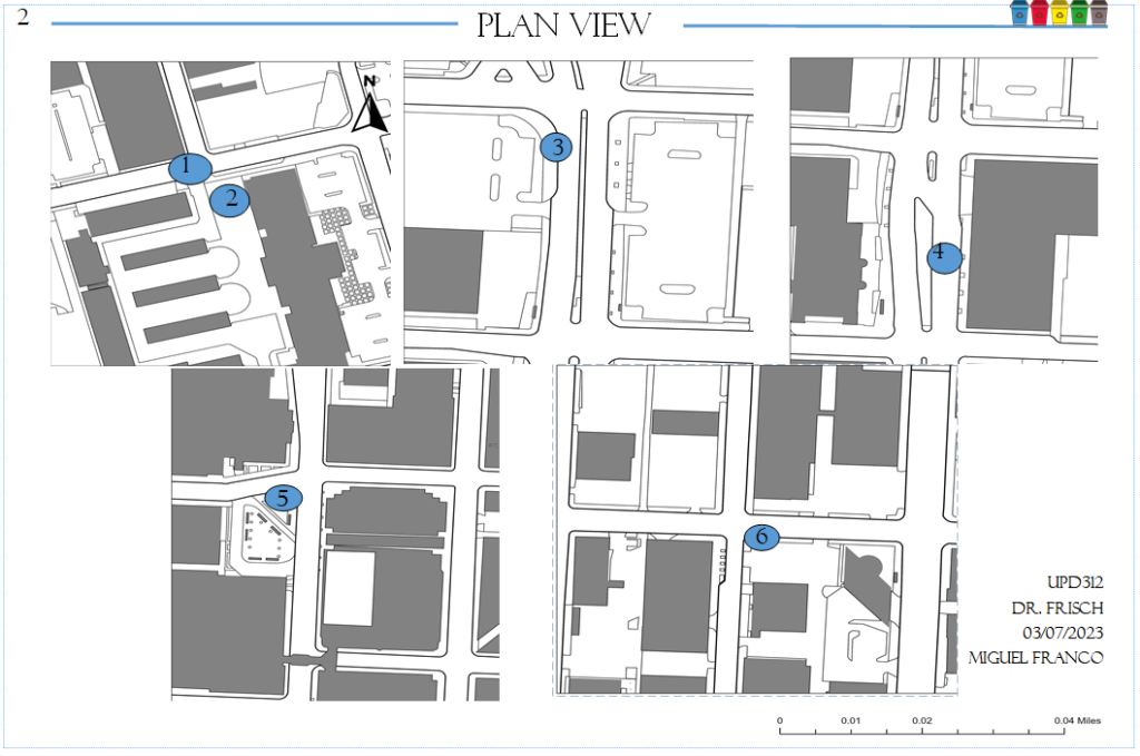
The first board illustrates perspectives of different bus stops from around Kansas City. The perspectives demonstrate the built environment and what makes a good bus stop. The stops go from the worst bus stops, to the best bus stops. The first image is a bus stop around the south loop in downtown Kansas City and the bus stop sign is hidden behind a no parking sign, is adjacent to a highway, and has the picture perfect example of a collapsing sidewalk. The second image is a better bus stop with a bench, that is also in the shade. The bus stop sign is also visible to both pedestrians and bus drivers. The one noticeable issue, and this is the main problem with bus stops, is that they are developed as an after thought when designing the streetscape. The bus stop is behind a protected bike lane. The third image is a bus stop that is completely covered, has some planters, a trash can, and is adjacent to a new mixed-use development. The fourth image is the bus stop next to the federal building. The bus stop is larger than the previous and is better covered and has more seating. The stop also has a trash can and has the metal tower to signal where the bus stop is. The bus stop arrival clock on the tower has been removed however. The fifth image is the first bus stop that was kept in mind when designing the street. The bike lanes go behind it, it is around stuff, and the bus stop is covered and has seating. The infrastructure of the built environment support these bus stops. The sixth and seventh images are of bus stops around the East Village Transit Center and they are examples of great bus stops. They are at grade, have trash cans, supporting active transportation infrastructure, planters, time, bathrooms, railings, and other types of supporting infrastructure. There is one flaw however, that will be touched in the next board.
Board two gives context for the location of the bus stops. The East Village Stops, or numbers 6&7 were the examples of fantastic bus stops in the previous board, but there weakness is illustrated here as there is quite literally nothing around them except a drive-through bank, highways, and parking lots. It was stuffed over there away from everything and it serves more bus lines than anywhere else in Kansas City. The site plans show the infrastructure and whether the bus stops are adjacent to stuff well. The black buildings contrast the other sites to the East Village site, which builds into the last board.
Board three has a section and detailed plan view that illustrates better why bus stop seven is a quality piece of infrastructure. Using the previous information that site from the last two boards and how the only problem that it has is that it’s isolated to create an argument for the intervention. The intervention for this project was to move the East Village Transit Center in front of Union Station. The large site plan gives a few aspects of what makes a good bus stop. The plan is to remove the parking lot in front of Union Station, as there are a lot of parking garages in the surrounding area already, and to add several other bus stops on the surrounding streets. This plan will put bus users front and center in Kansas City. The area around Union Station is a touristy area and is the cultural heart of the city. Moving the transit center signals perfectly a change in direction of Kansas City.
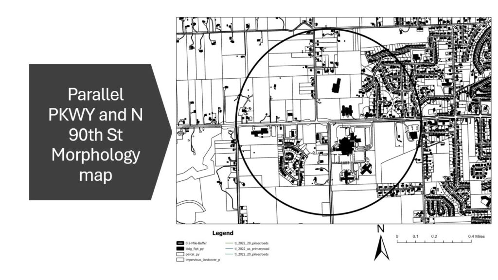
When we started this project, we picked our own proposed locations of mobility hubs within the bi-state corridor. My Area turned out to be at the intersction of Parallel Park Way and North 90th street. I started my study by analyzing the area and making a research on Demographics, housing, ways of commuting to work, and some economic analysis.Then i visited the site and took multiple photos which i will demonstrate later.
Figure 1 a morphology map of my area within half a mile radius.
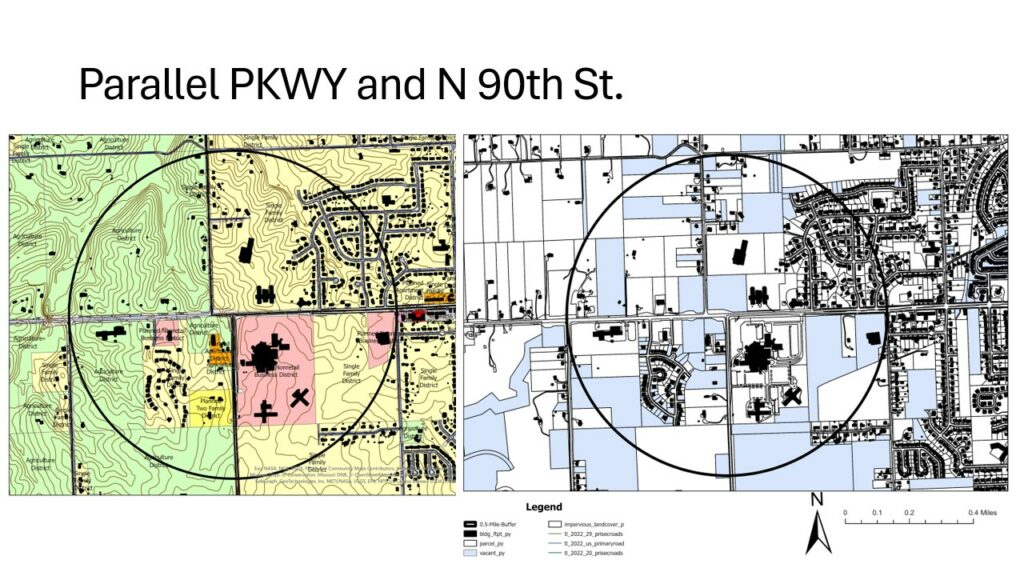
Figure 2 ( to the left,Current zoning of the area ) (to the right, morphology map with vacant parcels)
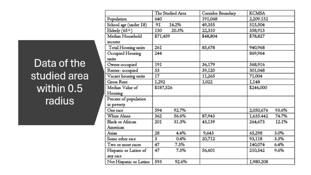
Figure 3 Data analysis for the area within half a mile radius compared with the bi-state corridor and KCMSA.
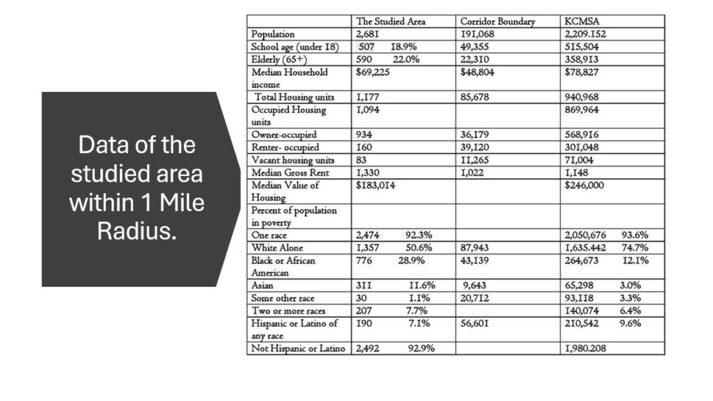
Figure 4 Data analysis for the area within half a mile radius compared with the bi-state corridor and KCMSA.
Figure 3 & 4 show how different my area is from the rest of the corridor. My area which is at the intersection of Parallel Pkwy & N90th St. in Kansas state is demographically have high numbers of white people than any other race comes in second place are the black or African American people while the rest of the corridor is much more diversified especially around KCK downtown and KCMO Area or compared to the metro area.My area has also higher number of Gross Rent compared to the Corridor or KCMSA and higher housing value.Median Income is also higher in the area than the corridor’s median income and almost close to the Metro’s median income. Housing structure there is more owner occupied than renter occupied and good amount of vacant lots compared to other dense ares in the metro or within the corridor like Downtown KCMO and Downtown Independence. The more we go West, the less density it gets how much residents there are per square mile.
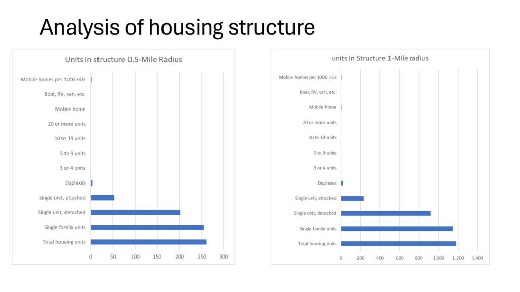
Figure 5 Housing Structure within 0.5 a mile and 1 mile.
according to figure 5 types of housing in my area whether we are looking within half a mile radius or within a mile, the most dominant type of housing structure is single-family units with single- family units detached having higher numbers than single units of attached. a few scattered duplexes and a very few mobile homes .
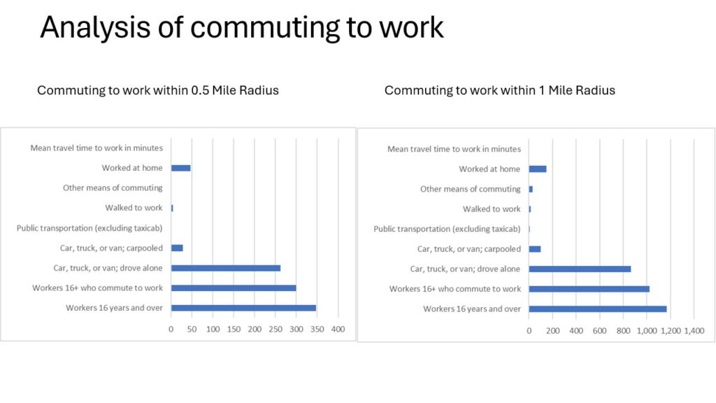
Figure 6 Analysis of commuting to work within 0.5 a mile and 1 mile.
The most common way to go to work around the specified area in KS state is by car, truck or van, so having your own vehicle. smaller number carpooled or worked from home and even very smaller number walked to work.
Figure 7 Inflow- outflow analysis
In figure 7, it shows that the number of people that worked and resided in the area are only ten with 1,433 coming from other areas and 692 of the residents of the specific area, work at other employment centers outside the studied area.
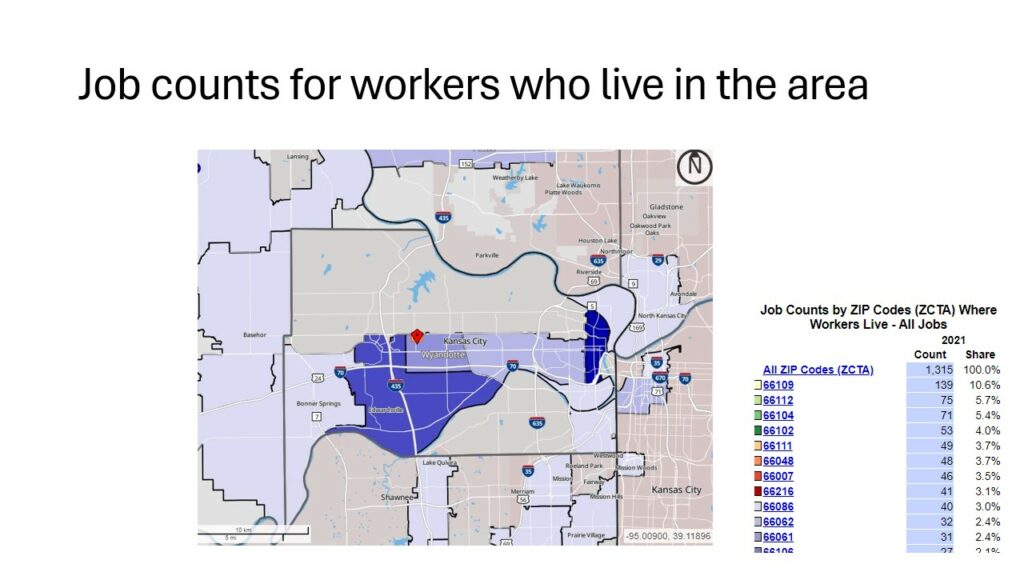
Figure 8 Job counts analysis for workers living in the assigned area
Figure 8 shows where workers who live in the specified area, where they commute to work according to zip codes.showing the highest numbers of jobs around Downtown KCK and Edwardsville.
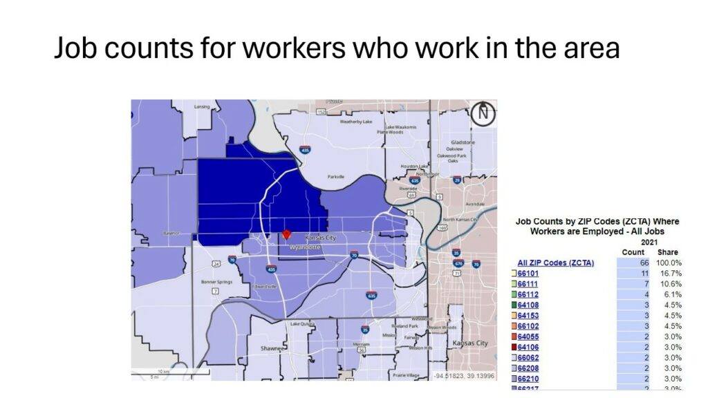
Figure 9 Job count analysis for workers working in the assigned area
Figure 9 shows where workers working in the specified area, where they live according to zip codes.showing the highest numbers of residential groups just north of the specified area at Leavenworth, Lansing, Basehor and Bethel.
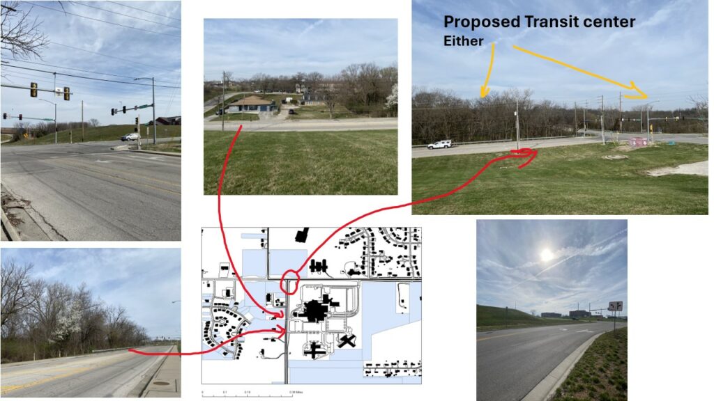
Figure 10 photos of the site.
Figure 10 is multiple photos of the site around the intersection of Parallel Pkwy and N 90th St. along with some views of both sides of 90th st.
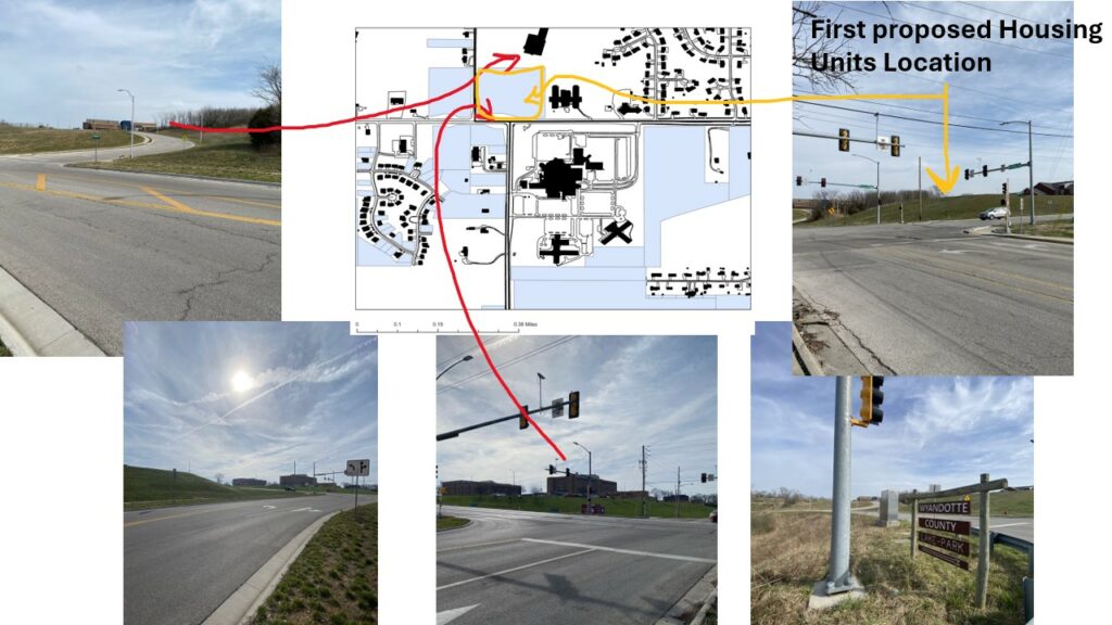
Figure 11 photos of the site.
Figure 12 photos of the site
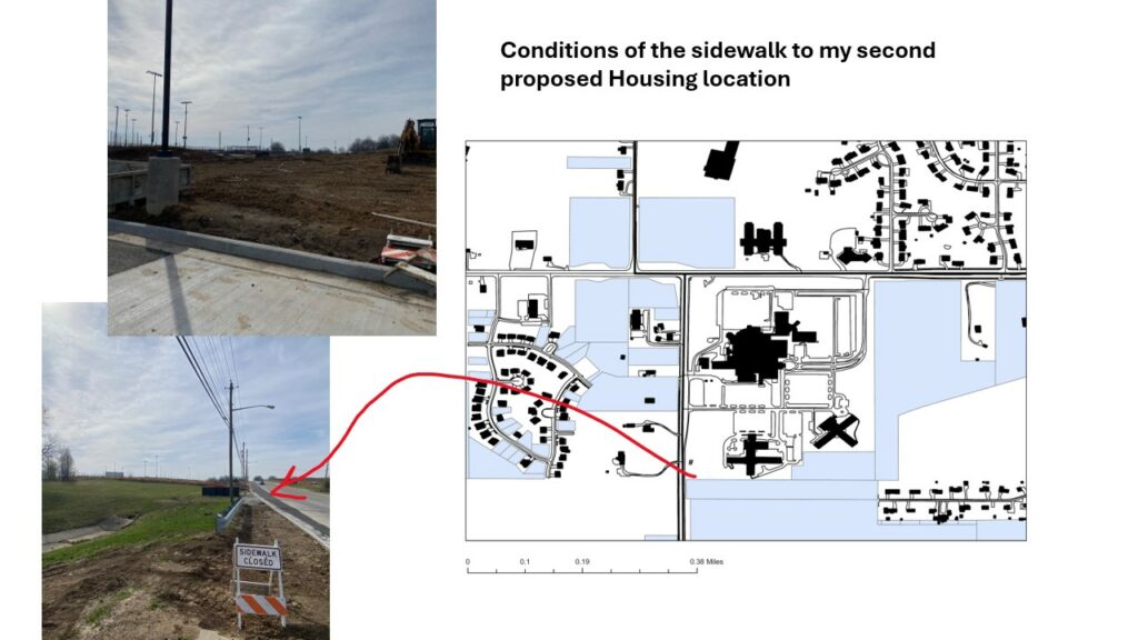
Conditions of the sidewalk around the Providence Medical Center.
Figure 13 photos of the site
more photos south of the Hospital and adjacent to the clinics in the south and then on the other side the Compass Minerals Fields.
The next steps after analyzing the area, would be to think and work on multiple ideas for development and redevelopment of the assigned areas.
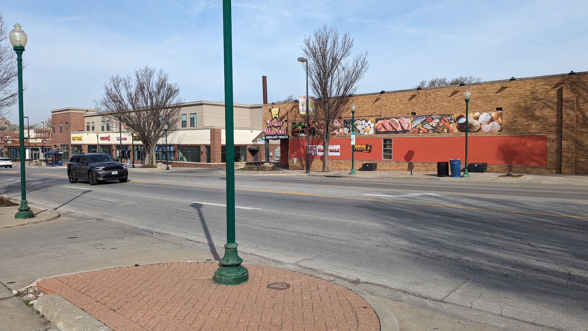
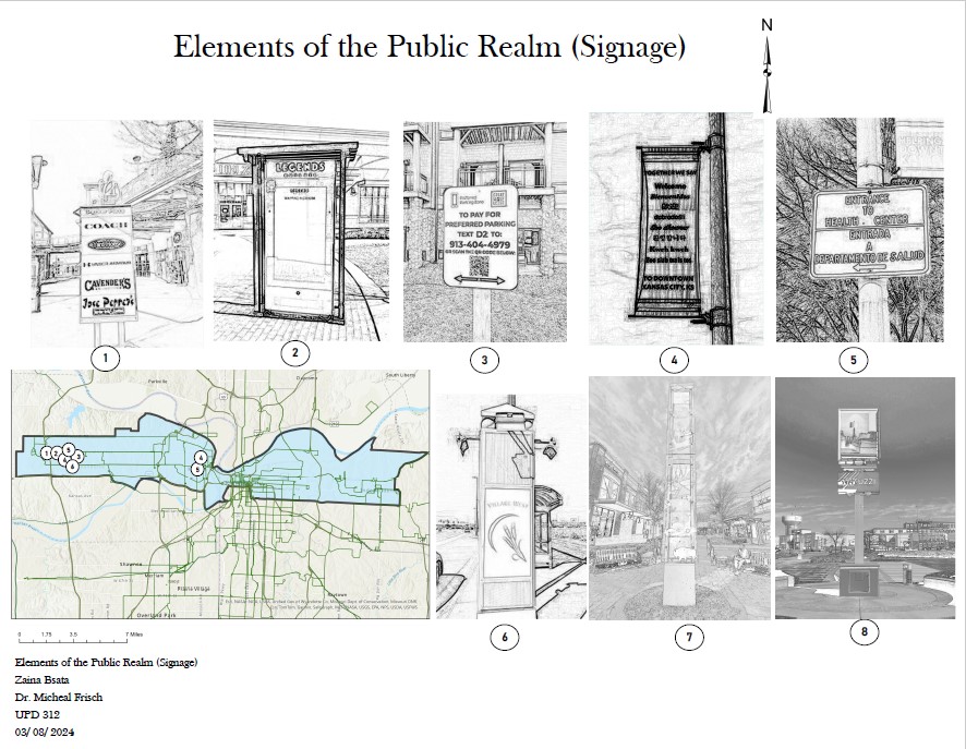
For this project, we were asked to take photos within our assigned area or outside the assigned area but still with The bi-State Corridor boundaries.I went ahead and took multiple photos, most of them within my area which is the far West side of the corridor and multiple others i thought were important and critical in illustrating my points. First we need to identify what a Public Realm is? A public Realm is for every one, it consists of starts, parks, green spaces and other outdoor spaces that are available without charge with everyone having access to. Public Realm is not isolated but it is within the context of it’s surrounding buildings whether private or public.Three key factors influence the public realm, which are, the buildings that define the space, the space itself, and the residents who live in those places.My assigned element of the public realm is signage. Signs are visual graphics created to display information to a particular audience.It is the Design or use of signs and symbols that convey the message.The term signage is documented to been popularized between 1975 and 1980.Then, it came to use in the 20th century to describe a class of signs typically for advertising and promotional signs.
Figure 1 First board ( 8 photos captured within Corridor boundary)
The first board (Figure 1) shows multiple photos i took within the corridor boundary, with most of them in and around village West-located at the far west of the corridor- some at KCK Downton and some around The Kansas City museum in the state of Missouri, with an adjacent context map to show the locations of my photos. I rendered my photos using photoshop to give some certain effects to my locations and emphasizing on certain points of the signs that will later on develop my theory on the signs and my findings.photos number one and two are chosen in the Legends outlet in KS, one shows how signs can reflect prominent figures of the area, two is just the closest basic example i could found in the area for navigational signs. Number three is great example to show hierarchy of the design with a white background and a QR code and it is taken in Great Wolf Lodge, KS .Number four and five are taken close to the Wyandotte City Hall, KS on Ann Ave, that area is more diversified than Village West where the legends outlet is, so we have multiple languages spoken there and that is reflected on my two signs.Number six is in the Village West area and it is a good example of identifying the place, aesthetically beautiful with the ability to add some features to it in the future like Music and Wireless internet access.Number seven is in the Legends Outlet, and it is a good example of defining public space with advertising simultaneously with the names of stores being displayed on, plus the proportionality and emphasis ( 7 principles of design). Last Photo was taken at the parking lot of Nebraska Furniture Mart, great way of defining and dividing the parking lot with definitely unique way of looking at it and some possible features to add as well in the future.
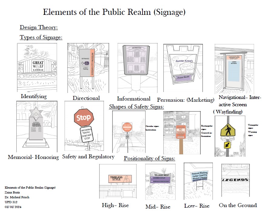
Figure 2 ( My Design Theory and what i’ve developed)
The second board (figure 2) shows the types of signs that i’ve discovered and put together, either with traditional ones that we all are familiar with or with new type of signages that are getting popular. Signs has seven types, they could be Informational, directional, identifying, persuasion, Navigational(interactive screen), Memorial and safety and regulatory. Identifying is to indicate services and facilities at the area such as room names and numbers. Informational, conveying information for services and facilities such as maps.Directional, showing the location of facilities, services and key areas such as directional arrows. Persuasion, promotional signage to persuade users of the merits of a company like highway signs and billboards.Navigational, maybe interior or exterior with interactive screens, most likely found in tourist attractions sites and museums with other ways of dynamic “wayfinding”.Safety and regulatory, signs giving warning or safety instructions such as warning signs, traffic signs and exit signs.Memorable and Honorary signs, those are dedicated to remember the service of a certain group of people or honoring beloved family members. There are different shapes of signs as well, they could be circular ( instructions), Triangular(Warning signs) and Rectangular (General information). Positionally of the signs affects a lot as well. Signs could be positioned very high like billboards and highway boards, Mid-Rise like identification boards, low-rise like informational boards or on the ground like identifications sign.
Figure 3 ( sections and my design intervention along with a perspective)
In figure 3 i had two sections illustrating the relationship between a human’s scale in relation with boards scale and specifically their height. First section is the scale relation ship between human and highway boards. Second section is the relationship between human and mid- high and low boards. My boards also contains to the up far right, traditional dimensions of well know boards. A perspective to the far left side.Then my design theory was about adding features to signs that are related to the Bi-State Corridor Goals and Marc’s goals. One of the goals is Broadband access, and with that i’ve added some new features to my navigational sign like wireless internet access. Other features could be added like light features and music. Another goal with the Bi- State corridor is security enhancement. With that i’ve added some features to my navigational sign like facial recognition cameras and connection with the police. License Plate readers could be added to signs or light poles that are adjacent to signs. Pedestrian crossings could be enhanced a lot as well by adding those new features to pedestrian crossing signs , light, connection with police centers and license plate readers.
Signs are always improving and they’re could be new ways of showing them in the future with new functions and far more features than they incorporate now.