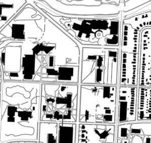
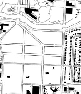
While studying my historic assigned are, which is MLK Blvd to 52nd St. from Holmes to Forest, I noticed some changes to the area through the years. in 1925 map, we can see that the university didn’t exist yet in this area. we can see that Holmes is going through MLK Blvd and it goes above Bruch Creak. Also, 51st St was still connected, and it didn’t get divided yet. In 1970 map, I noticed that some of the university building started to appear, as the UMKC is developing. Holmes cut it connection to MLK Blvd and stopped in the middle of the university where the library is. 51st St also were separated than its connection on Oak St. Moreover, in the bloke between Troost and Forest, we can see that there were still single-family houses exist. these houses are owned by the university, and it would be used to expand the university boundaries in the future. In the 2023 map, which is the current map of the university, we can see that the university is complete with all its buildings. If we compere the maps between 1925 and 2023, we will notice the differences in land use and streets connection and we will see how far the university development got. Comparing the 1970 and the 2023 maps, we will see that there are some streets have changed and there more buildings appear in the area while some of the buildings in 1970 got expanded like the library.
In conclusion, understanding the history of the university and how it changes through the years will help us understand the university urban environment. These historical analyses would help us understand the land use of the university and it would give us ideas to develop it. Also, this analysis helps us understand the timeline of the UMKC Volker camps and how this area come together to shape the university. We can be more aware of the university walkability and assets from these analyses which provides to us precious information.