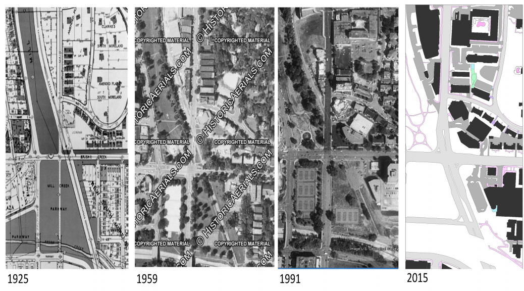
The maps above highlight the change in structures, impervious surfaces and land use along Main Street from 45th to Brush Creek over a 90 year period. Along Main Street, until 1991, you can see narrow and deep commercial buildings lining the street between 46th and 45th. As time past, many buildings were replaced with those of much larger footprint (American Century Investments, Holiday Inn and 2 E. Cleaver BLVD), a result attributed to car oriented development. One of the most notable details is the reconfiguration of Mill Creek Park. If you notice, in 1925 the park actually extended to Brush Creek only later to become tennis courts. Take note of the land where the Fountain View apartments are located in the bottom right corner of the 2015 map. Looking back in time you can see that area was built originally as single family homes and smaller apartment buildings. Another noticeable feature is the presence of the Dodson streetcar line that also served heavy rail into Westport from the south. This line operated until the mid to late 1950’s and has since been completely removed during the alignment of Brookside BLVD and Main Street. To sum up the transformation over time, structures have been rebuilt at larger scales, new structures have erected on vacant lots, impervious surfaces like streets have grown and widened and land uses have changed completely from residential to commercial or have been increased in their intensities. We are more familiar with the most recent map and the way the street along this stretch looks and feels. Its obvious that it has been built to serve the automobile and can be rather hazardous and unpleasant for the pedestrian to maneuver along this stretch of the corridor.