The Kansas City Missouri Parks and Boulevards system was the first plan initiated by the city that focused on future development. One of the most ambitious boulevards was the southern boulevard connecting the east side of 31st to the west side of 31st, Linwood Boulevard.
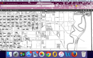
On the far east end of the boulevard is a reserved green space in the shape of a triangle: Linwood Blvd to the North, 31st to the south and Raytown Road (eventually, Van Brunt & Emanuel Clever II). The natural drainage towards Brush Creek at this point served as the natural ending point for Linwood Boulevard. In the earliest depiction of this area from 1895 (Figure 1) shows that it is not within the city limits and Linwood Boulevard did not formally stretch to there yet. In 1897 Kansas City MO annexed Westport MO, effectively lengthening Linwood Boulevard the maximum length natural features permit (referring to the natural barrier, the Blue River). Immediately following the annexation, in 1899, the Parks and Boulevard System plan officially began.
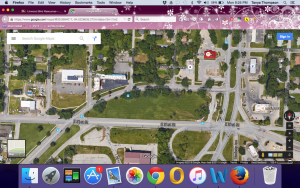
Linwood Boulevard spanned 3.43 miles ending with a natural green space Kessler describes as, “a park like effect, and an appearance differing radically from that of the ordinary residence street”. This area, at the end of Linwood, has been and continues to be nothing but a green space (Figure 2).
(Figure 1)
(Figure 2)
Quote: http://www.georgekessler.org/images/1893_Plan/1893_Plan_Improvement.PDF

