Campus planning
UMKC Campus’s Future (Dalton’s reading)
As Dalton’s text mentioned, Campus Planning has become more and more important overtime because older universities use it to redevelop space to serve new disciplines and increase student access. Campus planning has three geographical scales: The campus, campus community interface, and the larger campus district. This shows that campus
planning offers many opportunities for university and community planners to work together. As it helps to cover a wider array of institutions and issues.
University of Missouri Kansas City is considered a city school, where it is within the city and its roads and facilities are closely related with the city. It is a place where students come to attend class and commute back home (if they don’t live in the dorms). The buildings are spread out around UMKC boundaries and most of them are cut off by streets that are used by drivers who are usually not students, during rush hour to avoid traffic (not safe). The campus’s edges and boundaries are sort of undefined, the welcome sign is at an intersection on one side and the other big entrance is a big set of stairs leading up to the student union.
The main mode of transportation is cars (because Midwest) but also because living close to campus is almost impossible for a broke college student, the Volker Campus area has some of the most expensive rent prices in Kansas City, so for many students living 20 minutes away and commuting to school by car is the best option. Campus needs better walkability and connectivity within its boundaries and around students’
residential areas. This could be done by expanding the quad between Royal hall, Flarsheim hall and Haag hall towards other parts of campus, adding more stop signs on streets such as Troost to slow traffic and high speed drivers, creating better on and off campus public transport as well as adding better and bigger entrances and signage to welcome new
students.
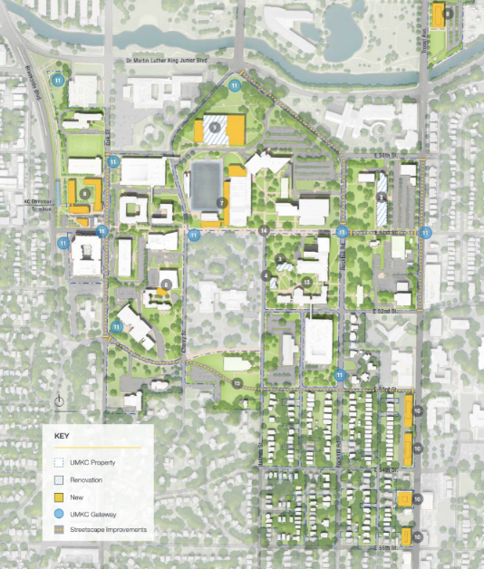
Scanning through the UMKC masterplan I recognize that the master plan’s main focus is the university and its borders and the plan is usually illustrated by the university’s governing board. It includes: background analysis, guiding principles, design framework, site plan, land use, transportation, infrastructure and implementation. Some of the proposed future plans that caught my eye are; the extension system for the streetcar on main street that will open in 2025 and will be available from campus, which will make it easier for students to access public transport without relying on their own cars, as well as a developed bus system that will provide service every 15 minutes, the downtown area plan that will create a walkable downtown and adding more student residential buildings close to campus.
This shows that UMKC master plan is in scale of Dalton’s plan, because it focused on the future of the physical campus financially, as well as increasing its student population, greater diversity, and openness to the community. Through expanding the downtown streetcar, provide better bus service, better walkability, which will therefore provide safety.
Dalton, Linda C., et al. “State of the Art in Planning for College and University Campuses: Site Planning and Beyond.” Journal of the American Planning Association, vol. 84, no. 2, 2018, pp. 145–161., https://doi.org/10.1080/01944363.2018.1435300.