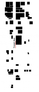
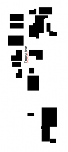
In 1950(figure ground on the left), the area from 18th street to 22nd street on Troost had a lot more buildings and Troost Avenue was still a straight street. Although it is hard to tell in the 2017 figure ground once Troost intersects with 20th, it curves up and is a bridge that goes over 22nd. I only had two intersections with streets, 18th and 19th, because of how the road has been altered. The map from 1950 was also before the highway was put in to the west of Troost. I believe the highway was a major thing that drove businesses away and the bridge as well because it was a complete reconstruction of the road. The area now is not cared for and majority of the buildings or just objects in that area have graffiti on them. Nobody is out on the streets and I barely saw anybody driving there. It is an industrial area with scrap and salvage yards lining the block. Everything that is a business is either locked up, has a fence with barbed wire, or advertises that they have security cameras. You can tell on certain buildings where the rest has been torn down or where the original windows have been taken out and replaced with conventional ones or just covered with brick completely. You can also tell where two building became one and were just painted the same color. Train tracks run through the area and there was no residential area from 18th to 22nd.

