Palestine and Egypt

A New Map of Palestine, or the Holy Land, with part of Egypt.

(photo courtesy of the LaBudde Special Collections)

This beautiful map of Palestine and Lower Egypt reflects growing European interest in the region. This map is based on an earlier map meant for Napoleon Bonaparte’s information and used surveys of the region meant for the English Admiralty. This updated map made use of additional surveys of the region, including an American survey. While meant to be an accurate picture of the region it was just as much meant as a map and guide to the places mentioned in the Bible and shows routes taken by the Israelites during their history and well as major biblical landmarks. Also given are details on the size of the Pyramids. Detailed engravings and vignettes make this map as much art as reference and a real jewel in the LaBudde Special Collections.


Terra Incognita

The collection of maps in the LaBudde Special Collections never fails to interest and astonish me. Here we have a map from 1513 that is the first printed map to show the Americas, broad swatches of which are simply labled “Terra incongnita”. A whole new world about to be explored.

One of the first maps to show the Americas.

One of the first maps to show the Americas.

“Martin Waldseemüller ‘Tabula Terra Nova’ from Claudius Ptolemaeus Geographia, Strasbourg, 1513. One of twenty maps containing new information gathered from many travels and voyages of discovery, which earned the work the title of ‘first modern atlas of the world.’ It was also the first printed map to show part of America.”–Cf. Martin Waldseemüller ‘Tabula Terra Nova’ WWW site / British Library Board, August 22, 2012

Finlandia-Swezzese

Map of the Gulf of Finlad Region ca. 170-?

(Photo courtesy of the LaBudde Special Collections)

This map may be small (just 19 x 27 cm.), but it is a true gem amongst the maps to be found in the LaBudde Special Collections. Hand drawn in ink on just one side, the map leaves no clue as to who drew it, when, or why. Centered on the Gulf of Finland and showing the countries and regions surrounding it. Swedish owned Finland comprises the northern bulk of the map, Sweden having rule over Finland since the 16th Century. Curving around through Karelia and the northern parts of Russia we see St. Petersburg and the Russian naval island of Kronstadt. St. Petersburg was founded only in 1703 by Peter the Great and so it’s inclusion on this map offers a clue to its dating. We also see a little mentioned region of Northern Russia named “Ingria” which was made a province of St. Petersburg in 1710 and was home to many Lutheran Finns at the time this map was likely drawn. West of Ingria we come to Livonia, or modern day Estonia, with the cities of Narva and its capital Reval (spelled Revel on the map). Revel is known today as Tallinn and is the oldest capital city in Northern Europe. Further down the coast we come to Riga, once a powerful member of the Hanseatic League but under Swedish rule at the time of this map. Also shown are the numerous islands and smaller towns that helped make this an important commercial region in Europe at the time. The detailed penmanship of the maker is just exquisite and it seems a shame that a map showing a region of Europe in flux must go uncredited to its maker.

  — Contributed by Garth Tardy, Library Specialist.


1817 map reveals the growth of a nation

A portrait of our growing nation can be found on the map entitled “Map of the Northern Part of Missouri Territory” dating from around 1817. The war of 1812 had just ended and the country was growing westward into the new territories. The map shows the area around St. Louis well settled and a spray of just created counties spreading westward. Perhaps the map’s most interesting feature is the marking of regions in both Illinois and Missouri as “Military Bounty Lands.” Military Bounty Lands were areas set aside to be given to eligible veterans for their service in the war of 1812. These were created by three different acts passed by Congress on December 24, 1811; January, 11, 1812; and May 6, 1812. Under these acts, non-commissioned officers and soldiers serving for five years, or their heirs, would be entitled to three months pay and 160 acres of public land as compensation for their military service. The map is definitely a snapshot of a young nation growing and expanding.

Garth Tardy, Library Specialist, Special Formats

Slave state or free state?

This map from LaBudde Special Collections shows again just how exciting and historically interesting maps can be. Drawn in 1851 and published in 1854, the map shows the state of Missouri as well as the area to its east: the highly contentious Nebraska territory, with no sign of Kansas as yet. The westward drive for expansion and the building of railroads meant that there was a lot of pressure to develop the territories.

There was a fight about whether Nebraska would be a slave state or free state. Congress fought like cats in a bag over the issue. Finally in 1854, in defiance of the Missouri Compromise and not without much animosity, the Kansas-Nebraska Act was passed which created the two territories, and launched us well on our way to the Civil War. This map captures the region just on the brink of all of that. Add in the Missouri counties census figures from 1840-1850 of freedmen and slaves included on the map and you have a dynamic portrait of a regional crisis about to explode on the national scene.

Garth Tardy, Library Specialist, Special Formats

Border War map tells a story

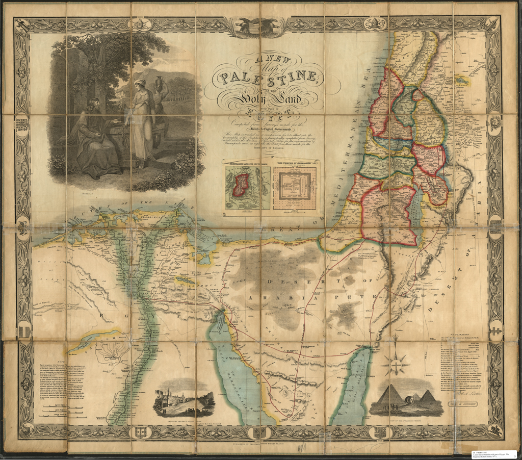
At first glance a map can seem a rather dull thing. Surely a map holds only the driest of data? Not so the map from the Miller Nichol’s Special Collections titled “Johnson’s Missouri and Kansas.” At first glance it’s a rather typical map showing squares and boxes, squiggly lines for rivers and railroads and all the usual map things. There are even a few black and white drawings of wagon trains and Native Americans to spruce the map up a bit. Then when you realize the map is from 1860 the drawings take on a new significance. These are drawings of what was current life for people on the frontiers of Missouri and Kansas. Add to that the building struggle between the free and slave states and Missouri and Kansas’ imminent Border War the map takes on a whole new life, steeped in frontier living, the movement Westward and the politics leading up to the Civil War.

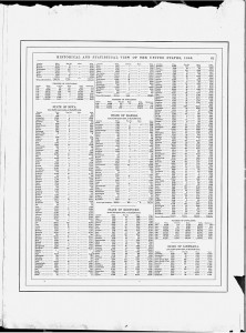
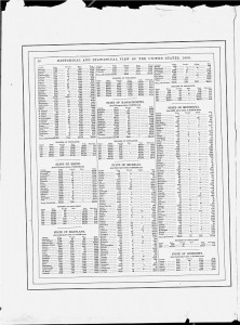
This map has yet more value to researchers than just the images. When the map is turned over it shows that it had been detached at some point from a larger publication titled “Historical and Statistical View of the United States 1860”. Sounds dull right? Not so! Statistics for populations of White, “Freed Coloreds” and Slaves are given, county by county for 1860 as well as for each census year available for the following states: Indiana (partial), Iowa, Kansas, Kentucky, Louisiana, Maine, Maryland, Massachusetts, Michigan, Minnesota and Mississippi (partial). Slavery statistics are hard to come by and this map unexpectedly provides a treasure trove of information. Being from Maine originally, I was intrigued to see that while there were no slaves in my home county of Aroostook (slavery having been outlawed in 1783) there were 26 freed slaves living there. As well as the fact that census data shows that between 1830 and 1840 two slaves were counted. One begins to wonder who owned them, what business the slave holder had in Maine and why he left. The numbers start to become real people. The fact that such data is given at all on such map probably indicates a strong Abolitionist view on the part of the publishers. Research material can come from many unexpected places and this map is certainly one of those rare gems.

2011-09-27_Missouri-Kansas_MapBack1(000-back01)2011-09-27_Missouri-Kansas_MapBack2(000-back02)


Garth Tardy, Library Specialist, Special Formats