Palestine and Egypt

A New Map of Palestine, or the Holy Land, with part of Egypt.

(photo courtesy of the LaBudde Special Collections)

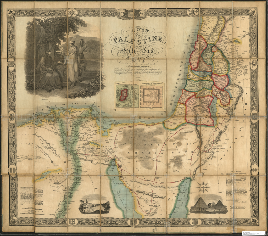
This beautiful map of Palestine and Lower Egypt reflects growing European interest in the region. This map is based on an earlier map meant for Napoleon Bonaparte’s information and used surveys of the region meant for the English Admiralty. This updated map made use of additional surveys of the region, including an American survey. While meant to be an accurate picture of the region it was just as much meant as a map and guide to the places mentioned in the Bible and shows routes taken by the Israelites during their history and well as major biblical landmarks. Also given are details on the size of the Pyramids. Detailed engravings and vignettes make this map as much art as reference and a real jewel in the LaBudde Special Collections.


Indiae Orientalis, insularumque adiacientium typus

Printed in 1570 this map of South East Asia by Abraham Ortelius shows what map makers did and didn’t know about this region.

Abraham Ortelius' 1570 map of the region.

Abraham Ortelius’ 1570 map of the region.

“… Ortelius’ map of SE Asia, Japan, and the Philippines, etc. The map includes Beach and other information drawn from Marco Polo.The map also includes a portion of the West Coast of North America, including several mythical names in California. Based upon Mercator’s world map of 1569.The difficulty of mapping this archipelago was such, that for centuries to come maps of this area remain faulty. Sumatra and Java are heavily oversized, and the Philippines are incomplete and without the Northern island of Luzon.The mermaids, who are beautifying themselves rather than heeding the whales’ attack on nearby ships, are based on those occurring on Diego Gutierrez map of America.”–Cf. Old map by Ortelius…. WWW site, June 20, 2013 (http://www.swaen.com/antique-map-of.php?id=13648)

The birth of an icon

Photo courtesy of the LaBudde Special Collections.

Photo courtesy of the LaBudde Special Collections.

With “Ornements en plomb & cuivre repoussé” by the foundries of Maison Monduit & Bechet and Monduit, Gaget, Gauthier & Cie we see history literally in the making. This set of 10 photoprints highlighting the foundries’ work was commissioned for the 1878 Paris World’s Fair or the (Exposition Universelle) and shows various buildings such as the Palace of Justice that they worked on. Also in the photos are two showing what is arguably their most famous work, the Statue of Liberty. One photo show’s her torch-bearing arm under construction in a workshop with a small scale model nearby and dozens of workmen.


Photo courtesy of the LaBudde Special Collections.

Photo courtesy of the LaBudde Special Collections.

The other photo shows the completed head on display at the World’s Fair, which was set up June 30, 1878 for display in the garden of the Trocadéro palace, while other pieces were on display in the Champs de Mars.
These two photos are an incredible piece of both American and French history and are definitely one of the treasures of the LaBudde Special Collections.

Terra Incognita

The collection of maps in the LaBudde Special Collections never fails to interest and astonish me. Here we have a map from 1513 that is the first printed map to show the Americas, broad swatches of which are simply labled “Terra incongnita”. A whole new world about to be explored.

One of the first maps to show the Americas.

One of the first maps to show the Americas.

“Martin Waldseemüller ‘Tabula Terra Nova’ from Claudius Ptolemaeus Geographia, Strasbourg, 1513. One of twenty maps containing new information gathered from many travels and voyages of discovery, which earned the work the title of ‘first modern atlas of the world.’ It was also the first printed map to show part of America.”–Cf. Martin Waldseemüller ‘Tabula Terra Nova’ WWW site / British Library Board, August 22, 2012

Finlandia-Swezzese

Map of the Gulf of Finlad Region ca. 170-?

(Photo courtesy of the LaBudde Special Collections)

This map may be small (just 19 x 27 cm.), but it is a true gem amongst the maps to be found in the LaBudde Special Collections. Hand drawn in ink on just one side, the map leaves no clue as to who drew it, when, or why. Centered on the Gulf of Finland and showing the countries and regions surrounding it. Swedish owned Finland comprises the northern bulk of the map, Sweden having rule over Finland since the 16th Century. Curving around through Karelia and the northern parts of Russia we see St. Petersburg and the Russian naval island of Kronstadt. St. Petersburg was founded only in 1703 by Peter the Great and so it’s inclusion on this map offers a clue to its dating. We also see a little mentioned region of Northern Russia named “Ingria” which was made a province of St. Petersburg in 1710 and was home to many Lutheran Finns at the time this map was likely drawn. West of Ingria we come to Livonia, or modern day Estonia, with the cities of Narva and its capital Reval (spelled Revel on the map). Revel is known today as Tallinn and is the oldest capital city in Northern Europe. Further down the coast we come to Riga, once a powerful member of the Hanseatic League but under Swedish rule at the time of this map. Also shown are the numerous islands and smaller towns that helped make this an important commercial region in Europe at the time. The detailed penmanship of the maker is just exquisite and it seems a shame that a map showing a region of Europe in flux must go uncredited to its maker.

  — Contributed by Garth Tardy, Library Specialist.