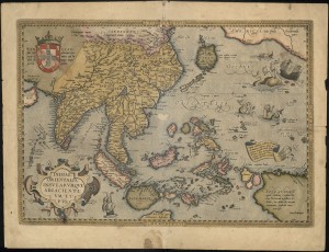
Printed in 1570 this map of South East Asia by Abraham Ortelius shows what map makers did and didn’t know about this region.
“… Ortelius’ map of SE Asia, Japan, and the Philippines, etc. The map includes Beach and other information drawn from Marco Polo.The map also includes a portion of the West Coast of North America, including several mythical names in California. Based upon Mercator’s world map of 1569.The difficulty of mapping this archipelago was such, that for centuries to come maps of this area remain faulty. Sumatra and Java are heavily oversized, and the Philippines are incomplete and without the Northern island of Luzon.The mermaids, who are beautifying themselves rather than heeding the whales’ attack on nearby ships, are based on those occurring on Diego Gutierrez map of America.”–Cf. Old map by Ortelius…. WWW site, June 20, 2013 (http://www.swaen.com/antique-map-of.php?id=13648)


I enjoy what you guys are usually up too. This kind of clever work and reporting!
Keep up the terrific works guys I’ve incorporated you guys to our blogroll.