
PROJECT
Goals:
The goal of the Guatemala Geohazards IRES program is for student participants to increase their scientific inquiry and research skills, to learn integrative field and lab research approaches to investigate exciting and cutting-edge geologic questions, and to practice international cooperation by collaborating side-by-side with Guatemalan students, professors, and industrial partners to address research questions on the long-term Quaternary record of geological hazards in Guatemala.
Participating Organizations:
U.S. Partners
- University of Missouri-Kansas City (UMKC)—Department of Earth and Environmental Sciences (Kansas City, MO, U.S.A.)
- Missouri University of Science and Technology (MS&T)—Department of Geosciences and Geological and Petroleum Engineering (Rolla, MO, U.S.A.)
- University of Missouri (MU) —Department of Geology (Columbia, MO, U.S.A.)
Guatemalan Partners:
- Universidad de San Carlos de Guatemala (USAC)—Centro de Estudios Superiores de Energia y Minas, Facultad de Ingeneieria (Guatemala City, Guatemala)
- Centro Universitario del Norte (CUNOR)—Department of Geology (Cobán, Guatemala)
- Cementos Progreso (Guatemala City, Guatemala)


Research focus:
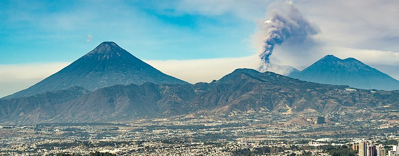
Guatemala is located at the triple junction between the North American plate to the north, Cocos oceanic plate to the west, and the Caribbean plate to the south and east (Fig. 1). This plate boundary setting of Guatemala exposes the country to numerous natural hazards including earthquakes, volcanic eruptions along the active Central American Volcanic Arc (CAVA), and landslides and floods that have intensified by more frequent tropical storms and hurricanes in a warming Earth. With a rapidly growing population in Guatemala, there has been an acceleration of infrastructure, industrial mining, and road construction projects that has led to new geological exposures that can be used to quantify recent and active geologic processes including the sequence, style, and timing of volcanic eruptions, the kinematic and displacement history of faults and past earthquakes, and study of the underlying properties leading to landslide failures. Through stratigraphic analyses of outcrops located along newly excavated roadcuts and mining exposures with the application of remote sensing technologies including drone aerial photography and Lidar and satellite-based radar imagery, student research projects in the Guatemala Geohazards IRES will seek to better understand the surficial processes and long-term history of natural hazards that pose a significant threat to populations in Guatemala.
Topical Groups:
- Volcanology Research Team – Volcanoes including Pacaya, Fuego, Acatenango, and Agua, and other volcanic centers along the Central American Volcanic Arc pose a significant geological hazard. The Guatemala City Metro sprawls over a high plateau composed of volcanic tuff and lava flows from explosive Quaternary volcanism although the actual volcanic stratigraphy is poorly defined. The abundance of wide-reaching tephras and valley-filling pyroclastic deposits has limited the reconstruction of the volcanic record from terrestrial deposits due to burial thus making the chance to investigate roadcuts a valuable opportunity to characterize deposits on land and focus on region-specific hazards. The stratigraphy records the integrated history of volcanic activity and structural evolution of the region that will provide the foundation for the study of the geohazards that impact Guatemala. Students will begin by characterizing the exposed stratigraphy with a focus on recognizing well-constrained and dated volcanic units, predominantly Quaternary ignimbrites from the Atitlan and Amatitlan calderas. The teams will then be able to pursue more specific research questions and hypotheses about the volcanic and seismic hazards.
- Paleoseismology Research Team – Earthquakes are a major hazard in Guatemala. The 1976 Guatemalan earthquake ruptured the left-lateral, strike-slip Motagua fault along the plate boundary separating the North American and Caribbean plates. There are four sources of seismicity in Guatemala: the Cocos subduction zone, the dextral Jalpatagua Fault and associated volcanic activity in the faults vicinity, the left-lateral faults of the Polochic- Motagua Fault System, and the basin-bounding normal faults of the extensional Guatemala City graben system. The earthquake research team will focus on addressing Quaternary faulting, deformation, and earthquake history. The overarching goal is to link faulting to the other research components on volcanic stratigraphy and surficial processes of the project to help quantify rates of deformation. Student research projects will focus on studying faults exposed in outcrop and in locations identified for potential paleoseismic trenching and fault slip rate studies.
- Surficial Processes Research Team – Landslides are prevalent hazards in the high volcanic plateau that is traversed by steep ravines or barrancos and active faults in Guatemala City. Slope failures in the steep terrain have been triggered by seismic shaking as in the 1976 earthquake, by torrential rains from hurricanes, and by oversteeping of slopes due to construction. Landslide susceptibility maps based on topography can help identify areas of hazard and potential failure. Site-specific field studies examining slide kinematics (e.g., repeat survey GNSS or photogrammetry) can be combined with geophysical imaging of slide geometry to assess failure mechanisms and the relationship with the substratum. Additionally, surficial processes, including mass wasting and fluvial incision can be used to quantify active tectonic deformation. Student research projects will focus on constraining rates of down-slope transport and assessing fluvial incision across active faults. Local landslide inventories will be assessed using aerial imagery (optical and radar), combined with field-based mapping. An overarching hypothesis is that, where rates of uplift are higher, we expect to see more significant expressions of mass wasting in response to the tectonic forcing.

