All posts by Eyborit Esquivel

The Paseo and Wayne Ave

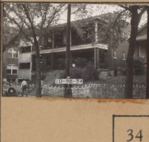
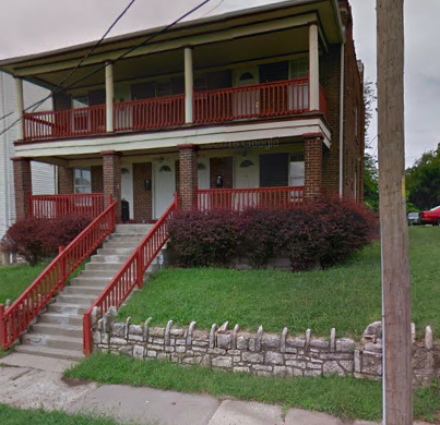
My assigned area was mostly residential. When putting together the according tracts, I noticed an extreme amount of development between the year 1895 and 1909. Between the year of 1950 to 2018, my area as a whole went through a destruction of many of its homes. This is something that was really interesting to me because when you compare these two Sanborn maps you can see how they appear very similar in terms of the amount of developed land and the amount of vacant land. Besides the residential homes, there was also a few apartment buildings. The architectural style of these buildings was that of a colonnade style. This is shown in the pictures below. The photo from the left was from the Kansas City 1940 Tax Assessment Photographs. The photo on the right was from google maps. We are able to see how the home that was located on the right of the apartment building from 1940 was destroyed since it is now present in the 2018 image.

Troost Avenue and 34th through 37th street

Kansas City is the heart of America. Troost Avenue runs north-south, cutting the city in half  while also serving as a racial dividing line. I am analyzing the development over time of Troost avenue, focused specifically on 34th through 37th street. The time periods examined for this project are three years in specific, 1950, 2000, and 2010. The 3 levels that these dates were each examined by were the Census Tract, Kansas City level, and for 2010 only, the Metropolitan Statistical Area. For each year at each level, the general population info, demographics, and housing info were examined. The census tracts that corresponded to my designated area, were tracts 50 through 53. From 1950 to 2000, and from 2000 to 2010, the total population in each of the tracts decreased tremendously. The total population for the year 1950 had the largest total population out of all three years that were examined. In terms of the number of housing units, as a whole we see a decrease of units from 1950 to 2000, and 2000 to 2010. The only exception to this would be tract #51 from the year 1950 to 2000, for the number of housing units in this tract actually increased from 964 to 1,123 units.

https://docs.google.com/spreadsheets/d/1HG6fS-u_X5ltYrMlVpOjR2JzlGKARBcON2qNlL0GYw4/edit#gid=0

Troost Ave between 34th street and 37th street

Troost avenue between 34th through 37th street are areas that have drastically changed over time. In 1917, these blocks were mostly vacant with just a few buildings. Thirty-four years later, the vacant lots in this area had completely vanished. In their place was now housing, and an increased amount of commercial buildings. Fast forward to today, many homes and businesses have been demolished, and those who weren’t are left unoccupied.

These are two pictures from 1940(left) and 2017 (right). As you can see the picture on the left shows a business with housing on both sides. Now in 2017, the lot where the business once was is now unoccupied while the housing next to it have been demolished, leaving a vacant space.

Photograph from 1940 Tax assessor.                       Photograph from google maps.